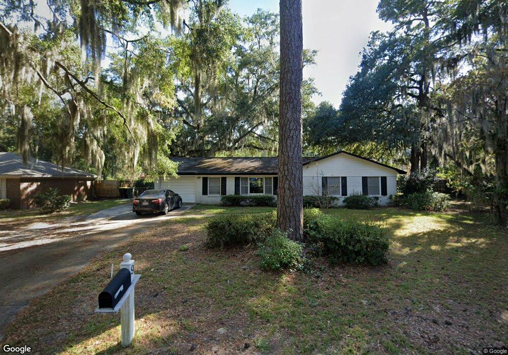
9 Burnt Tree Cir Savannah, GA 31419
Windsor Forest NeighborhoodEstimated Value: $286,783 - $352,000
4
Beds
2
Baths
1,736
Sq Ft
$184/Sq Ft
Est. Value
About This Home
This home is located at 9 Burnt Tree Cir, Savannah, GA 31419 and is currently estimated at $319,946, approximately $184 per square foot. 9 Burnt Tree Cir is a home located in Chatham County with nearby schools including Windsor Forest Elementary School, Windsor Forest High School, and Southwest Middle School.
Ownership History
Date
Name
Owned For
Owner Type
Purchase Details
Closed on
Mar 31, 2011
Sold by
Bouknight Alice M
Bought by
Bouknight Alice M and Howard Mary Alice
Current Estimated Value
Purchase Details
Closed on
Mar 30, 2011
Sold by
Whitaker Grady A and Davis Robin W
Bought by
Whitaker Michael O
Purchase Details
Closed on
Feb 1, 2007
Sold by
Not Provided
Bought by
Bouknight Alice M and Howard Mary Alice
Create a Home Valuation Report for This Property
The Home Valuation Report is an in-depth analysis detailing your home's value as well as a comparison with similar homes in the area
Home Values in the Area
Average Home Value in this Area
Purchase History
| Date | Buyer | Sale Price | Title Company |
|---|---|---|---|
| Bouknight Alice M | -- | -- | |
| Bouknight Alice M | -- | -- | |
| Whitaker Michael O | -- | -- | |
| Bouknight Alice M | -- | -- |
Source: Public Records
Tax History Compared to Growth
Tax History
| Year | Tax Paid | Tax Assessment Tax Assessment Total Assessment is a certain percentage of the fair market value that is determined by local assessors to be the total taxable value of land and additions on the property. | Land | Improvement |
|---|---|---|---|---|
| 2025 | $2,612 | $75,840 | $26,000 | $49,840 |
| 2024 | $2,612 | $69,880 | $26,000 | $43,880 |
| 2023 | $443 | $71,560 | $22,000 | $49,560 |
| 2022 | $623 | $55,040 | $14,400 | $40,640 |
| 2021 | $2,397 | $46,600 | $9,600 | $37,000 |
| 2020 | $1,223 | $45,920 | $9,600 | $36,320 |
| 2019 | $2,363 | $45,920 | $9,600 | $36,320 |
| 2018 | $1,168 | $40,840 | $9,600 | $31,240 |
| 2017 | $1,045 | $41,960 | $9,600 | $32,360 |
| 2016 | $1,035 | $41,760 | $9,600 | $32,160 |
| 2015 | $2,008 | $43,000 | $9,600 | $33,400 |
| 2014 | $2,108 | $48,800 | $0 | $0 |
Source: Public Records
Map
Nearby Homes
- 5 Birchwood Cove
- 708 Windsor Rd
- 12300 Apache Ave Unit 312
- 12300 Apache Ave Unit 1406
- 12300 Apache Ave Unit 1106
- 12300 Apache Ave Unit 1122
- 12300 Apache Ave Unit 213
- 12300 Apache Ave Unit 804
- 12300 Apache Ave Unit 913
- 12300 Apache Ave Unit 307
- 12300 Apache Ave Unit 605
- 12300 Apache Ave Unit 224
- 12300 Apache Ave Unit 1712
- 12300 Apache Ave Unit 704
- 12608 Largo Dr
- 627 Northbrook Rd
- 12502 Apache Ave Unit 38
- 12502 Apache Ave Unit 18
- 13609 Rockingham Rd
- 121 Hopeland Dr
- 8 Burnt Tree Cir
- 10 Burnt Tree Cir
- 10 S Stillwood Cir
- 12 S Stillwood Cir
- 11 Burnt Tree Cir
- 14 S Stillwood Cir
- 7 Burnt Tree Cir
- 8 S Stillwood Cir
- 16 Windsor On the Marsh
- 18 Windsor On the Marsh
- 6 Burnt Tree Cir
- 12 Burnt Tree Cir
- 5 Burnt Tree Cir
- 4 Burnt Tree Cir
- 6 S Stillwood Cir
- 20 Windsor On the Marsh
- 15 S Stillwood Cir
- 17 S Stillwood Cir
- 3 Burnt Tree Cir
- 13 Burnt Tree Cir