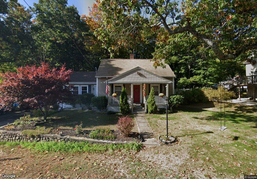
9 Curtis Ln Bedford, NH 03110
Bedford NeighborhoodEstimated Value: $493,000 - $520,000
2
Beds
1
Bath
1,221
Sq Ft
$417/Sq Ft
Est. Value
About This Home
This home is located at 9 Curtis Ln, Bedford, NH 03110 and is currently estimated at $508,708, approximately $416 per square foot. 9 Curtis Ln is a home located in Hillsborough County with nearby schools including Mckelvie Intermediate School, Ross A. Lurgio Middle School, and Bedford High School.
Ownership History
Date
Name
Owned For
Owner Type
Purchase Details
Closed on
Mar 13, 2012
Sold by
Rheaume Ronald E
Bought by
Rheaume Ronald E and Rheaume Gail
Current Estimated Value
Purchase Details
Closed on
Jun 30, 2004
Sold by
Lennon Dawn M
Bought by
Rheaume Ronald E
Home Financials for this Owner
Home Financials are based on the most recent Mortgage that was taken out on this home.
Original Mortgage
$187,920
Interest Rate
6.3%
Mortgage Type
Purchase Money Mortgage
Create a Home Valuation Report for This Property
The Home Valuation Report is an in-depth analysis detailing your home's value as well as a comparison with similar homes in the area
Home Values in the Area
Average Home Value in this Area
Purchase History
| Date | Buyer | Sale Price | Title Company |
|---|---|---|---|
| Rheaume Ronald E | -- | -- | |
| Rheaume Ronald E | $234,900 | -- |
Source: Public Records
Mortgage History
| Date | Status | Borrower | Loan Amount |
|---|---|---|---|
| Previous Owner | Rheaume Ronald E | $172,400 | |
| Previous Owner | Rheaume Ronald E | $187,920 |
Source: Public Records
Tax History Compared to Growth
Tax History
| Year | Tax Paid | Tax Assessment Tax Assessment Total Assessment is a certain percentage of the fair market value that is determined by local assessors to be the total taxable value of land and additions on the property. | Land | Improvement |
|---|---|---|---|---|
| 2024 | $6,773 | $428,400 | $187,600 | $240,800 |
| 2023 | $6,340 | $428,400 | $187,600 | $240,800 |
| 2022 | $5,882 | $334,200 | $138,900 | $195,300 |
| 2021 | $5,728 | $334,200 | $138,900 | $195,300 |
| 2020 | $4,765 | $238,000 | $100,900 | $137,100 |
| 2019 | $4,510 | $238,000 | $100,900 | $137,100 |
| 2018 | $4,276 | $209,600 | $95,000 | $114,600 |
| 2017 | $3,786 | $200,200 | $95,000 | $105,200 |
| 2016 | $4,031 | $180,200 | $71,300 | $108,900 |
| 2015 | $4,101 | $180,200 | $71,300 | $108,900 |
| 2014 | $4,055 | $180,200 | $71,300 | $108,900 |
| 2013 | $3,995 | $180,200 | $71,300 | $108,900 |
Source: Public Records
Map
Nearby Homes
- 90 Glenwood Ave
- 21 Prairie Ct
- 122 Patterson St
- 30 Tanglewood Ct
- 52 Erie St
- 60 Geneva St
- 46 Geneva St
- 133 Bismark St
- 0 Huntress St
- 3 Danforth Dr
- 3 Churchill Ct Unit UN111
- 80 Wendover Way
- 58 Violet St
- 99 Becker St
- 49 Harvell St Unit 9
- 220 Mast Rd
- 10 Pimlico Ct Unit UN66
- 34 Briston Ct
- 380 Rockland Ave
- 166 Varney St