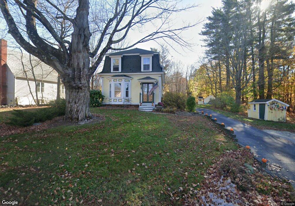
9 Hall Rd Londonderry, NH 03053
Estimated Value: $521,000 - $653,000
3
Beds
2
Baths
1,731
Sq Ft
$333/Sq Ft
Est. Value
About This Home
This home is located at 9 Hall Rd, Londonderry, NH 03053 and is currently estimated at $575,804, approximately $332 per square foot. 9 Hall Rd is a home with nearby schools including North Londonderry Elementary School, Londonderry Middle School, and Londonderry Senior High School.
Ownership History
Date
Name
Owned For
Owner Type
Purchase Details
Closed on
Jun 29, 2005
Sold by
Sylvester Nicole G
Bought by
Knights Jennifer F and Knights Jason
Current Estimated Value
Purchase Details
Closed on
Aug 1, 2002
Sold by
Puccio Miguel and Puccio Kelly C
Bought by
Sylvester Nicole G and Sylvester Alan E
Purchase Details
Closed on
Aug 21, 2000
Sold by
Bronson Patrick J and Bronson Hope E
Bought by
Puccio Miguel and Puccio Kelly
Create a Home Valuation Report for This Property
The Home Valuation Report is an in-depth analysis detailing your home's value as well as a comparison with similar homes in the area
Home Values in the Area
Average Home Value in this Area
Purchase History
| Date | Buyer | Sale Price | Title Company |
|---|---|---|---|
| Knights Jennifer F | $286,000 | -- | |
| Knights Jennifer F | $286,000 | -- | |
| Sylvester Nicole G | $237,000 | -- | |
| Sylvester Nicole G | $237,000 | -- | |
| Puccio Miguel | $159,900 | -- | |
| Puccio Miguel | $159,900 | -- |
Source: Public Records
Mortgage History
| Date | Status | Borrower | Loan Amount |
|---|---|---|---|
| Open | Puccio Miguel | $201,450 | |
| Closed | Puccio Miguel | $211,500 |
Source: Public Records
Tax History Compared to Growth
Tax History
| Year | Tax Paid | Tax Assessment Tax Assessment Total Assessment is a certain percentage of the fair market value that is determined by local assessors to be the total taxable value of land and additions on the property. | Land | Improvement |
|---|---|---|---|---|
| 2024 | $7,255 | $449,500 | $178,800 | $270,700 |
| 2023 | $7,035 | $449,500 | $178,800 | $270,700 |
| 2022 | $6,536 | $353,700 | $134,200 | $219,500 |
| 2021 | $6,501 | $353,700 | $134,200 | $219,500 |
| 2020 | $6,208 | $308,700 | $106,300 | $202,400 |
| 2019 | $5,986 | $308,700 | $106,300 | $202,400 |
| 2018 | $5,380 | $246,800 | $88,600 | $158,200 |
| 2017 | $5,333 | $246,800 | $88,600 | $158,200 |
| 2016 | $5,147 | $239,400 | $88,600 | $150,800 |
| 2015 | $5,032 | $239,400 | $88,600 | $150,800 |
| 2014 | $5,049 | $239,400 | $88,600 | $150,800 |
| 2011 | -- | $243,400 | $88,600 | $154,800 |
Source: Public Records
Map
Nearby Homes
- 8 Barksdale Ave
- 28 Barksdale Ave
- 27 Buckingham Dr
- 5 Webster Rd
- 17 Welch Rd
- 4 Crestview Cir Unit 119
- 15 Harvey Rd
- 32 Noyes Rd
- 38 Bartley Hill Rd
- 36 Perkins Rd
- 10100 S Willow St Unit 214
- 10100 S Willow St Unit 101
- 10100 S Willow St Unit 109
- 10100 S Willow St Unit 207
- 10100 S Willow St Unit 110
- 10100 S Willow St Unit 204
- 50 Bartley Hill Rd
- 1035 S Mammoth Rd Unit 6
- 10 Auburn Rd
- 19 Auburn Rd