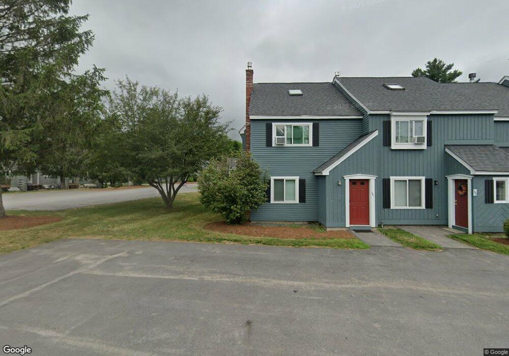
9 Johnson Dr Unit 197 Woodstock, NH 03262
Estimated Value: $427,820 - $468,000
4
Beds
3
Baths
1,411
Sq Ft
$322/Sq Ft
Est. Value
About This Home
This home is located at 9 Johnson Dr Unit 197, Woodstock, NH 03262 and is currently estimated at $453,955, approximately $321 per square foot. 9 Johnson Dr Unit 197 is a home located in Grafton County with nearby schools including Lin-Wood Public Elementary School.
Ownership History
Date
Name
Owned For
Owner Type
Purchase Details
Closed on
May 19, 2016
Sold by
Ferrante Jeffrey A
Bought by
Sakharuk Timmar
Current Estimated Value
Purchase Details
Closed on
Apr 4, 2012
Sold by
Yu Eva L
Bought by
Fdic
Purchase Details
Closed on
Mar 6, 2012
Sold by
Yu Eval L
Bought by
United Commercial Bank
Purchase Details
Closed on
Jan 19, 2011
Sold by
Yu Eva L
Bought by
East West Bank
Create a Home Valuation Report for This Property
The Home Valuation Report is an in-depth analysis detailing your home's value as well as a comparison with similar homes in the area
Home Values in the Area
Average Home Value in this Area
Purchase History
| Date | Buyer | Sale Price | Title Company |
|---|---|---|---|
| Sakharuk Timmar | $175,000 | -- | |
| Fdic | -- | -- | |
| United Commercial Bank | -- | -- | |
| East West Bank | $155,100 | -- |
Source: Public Records
Mortgage History
| Date | Status | Borrower | Loan Amount |
|---|---|---|---|
| Previous Owner | East West Bank | $142,500 |
Source: Public Records
Tax History Compared to Growth
Tax History
| Year | Tax Paid | Tax Assessment Tax Assessment Total Assessment is a certain percentage of the fair market value that is determined by local assessors to be the total taxable value of land and additions on the property. | Land | Improvement |
|---|---|---|---|---|
| 2024 | $4,202 | $206,800 | $0 | $206,800 |
| 2023 | $4,020 | $206,800 | $0 | $206,800 |
| 2022 | $3,801 | $206,800 | $0 | $206,800 |
| 2021 | $3,929 | $206,800 | $0 | $206,800 |
| 2020 | $4,126 | $206,800 | $0 | $206,800 |
| 2019 | $3,828 | $176,500 | $0 | $176,500 |
| 2018 | $3,525 | $176,500 | $0 | $176,500 |
| 2016 | $3,497 | $175,800 | $0 | $175,800 |
| 2015 | $3,328 | $175,800 | $0 | $175,800 |
| 2014 | $3,366 | $178,200 | $0 | $178,200 |
| 2012 | $3,357 | $187,730 | $0 | $187,730 |
Source: Public Records
Map
Nearby Homes
- 17 Ridge Dr Unit A-14
- 65 Riverfront Dr Unit 217
- 45 Riverfront Dr Unit 242
- 16 Riverfront Dr Unit 293
- 16 Riverfront Dr Unit 292
- 23 Oakes St
- 14 Monroe Dr Unit 92
- 6 Monroe Dr Unit 111
- 11 Cascade Dr Unit 288
- 164 Deer Park Dr Unit 160D
- 164 Deer Park Dr Unit 161D
- 164 Deer Park Dr Unit 168D
- 156 Deer Park Dr Unit 135 A
- 56 Kancamagus Hwy
- 206-011 Lost River Rd
- 9 Moose Ln
- 25 Main St
- 34 Franklin St
- 5 Robin Rd Unit 1
- 252-254 Lost River Rd
- 9 Johnson Dr
- 9 Johnson Dr Unit 196
- 11 Johnson Drive #200
- 15 Johnson Drive #208 Dr Unit 208
- 9 Johnson Drive #197 Unit 197
- 11 Johnson Dr Unit 200
- 11 Johnson Dr Unit 199
- 187 Jackson Dr Unit 187
- 181 Jackson Dr Unit 181
- 154 Jackson Dr Unit 154
- 186 Jackson Dr
- 13 Johnson Dr Unit 205
- 13 Johnson Dr Unit 204
- 5 Johnson Dr Unit 194
- 5 Johnson Dr Unit 198
- 15 Johnson Dr Unit 207
- 15 Johnson Dr Unit 208
- 6 Grant Dr Unit 168
- 198 Johnson Dr Unit 198
- 191 Johnson Dr Unit 191