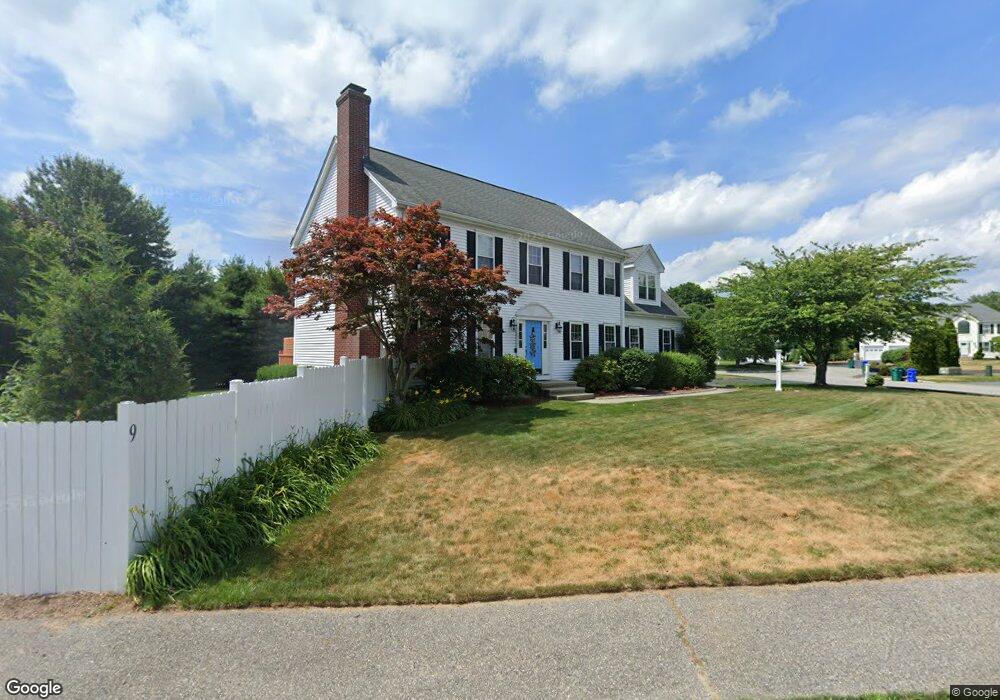
9 Kensington Rd Attleboro, MA 02703
Estimated Value: $652,000 - $806,000
4
Beds
3
Baths
2,400
Sq Ft
$304/Sq Ft
Est. Value
About This Home
This home is located at 9 Kensington Rd, Attleboro, MA 02703 and is currently estimated at $729,855, approximately $304 per square foot. 9 Kensington Rd is a home located in Bristol County with nearby schools including Hill-Roberts Elementary School, Robert J. Coelho Middle School, and Attleboro High School.
Ownership History
Date
Name
Owned For
Owner Type
Purchase Details
Closed on
Oct 24, 2003
Sold by
Wb Constr & Dev
Bought by
Larkin Michael V and Larkin Dawn E
Current Estimated Value
Home Financials for this Owner
Home Financials are based on the most recent Mortgage that was taken out on this home.
Original Mortgage
$167,000
Outstanding Balance
$77,611
Interest Rate
6.15%
Mortgage Type
Purchase Money Mortgage
Estimated Equity
$652,244
Create a Home Valuation Report for This Property
The Home Valuation Report is an in-depth analysis detailing your home's value as well as a comparison with similar homes in the area
Home Values in the Area
Average Home Value in this Area
Purchase History
| Date | Buyer | Sale Price | Title Company |
|---|---|---|---|
| Larkin Michael V | $384,000 | -- |
Source: Public Records
Mortgage History
| Date | Status | Borrower | Loan Amount |
|---|---|---|---|
| Open | Larkin Michael V | $167,000 |
Source: Public Records
Tax History Compared to Growth
Tax History
| Year | Tax Paid | Tax Assessment Tax Assessment Total Assessment is a certain percentage of the fair market value that is determined by local assessors to be the total taxable value of land and additions on the property. | Land | Improvement |
|---|---|---|---|---|
| 2025 | $7,709 | $614,300 | $166,500 | $447,800 |
| 2024 | $7,287 | $572,400 | $149,800 | $422,600 |
| 2023 | $6,796 | $496,400 | $151,500 | $344,900 |
| 2022 | $6,487 | $448,900 | $144,300 | $304,600 |
| 2021 | $6,457 | $436,300 | $138,800 | $297,500 |
| 2020 | $6,157 | $422,900 | $132,600 | $290,300 |
| 2019 | $6,000 | $423,700 | $130,000 | $293,700 |
| 2018 | $5,789 | $390,600 | $126,400 | $264,200 |
| 2017 | $5,638 | $387,500 | $123,100 | $264,400 |
| 2016 | $5,458 | $368,300 | $115,000 | $253,300 |
| 2015 | $5,293 | $359,800 | $115,000 | $244,800 |
| 2014 | $5,223 | $351,700 | $109,900 | $241,800 |
Source: Public Records
Map
Nearby Homes
- 18 Saint James Place
- 15 Kensington Rd
- 11 Saint James Place
- 24 Saint James Place
- 21 Kensington Rd
- 24 Kensington Rd
- 30 Saint James Place
- 35 Saint James Place
- 5 Kensington Rd
- 41 Saint James Place
- 12 Kensington Rd
- 30 Kensington Rd
- 17 Saint James Place
- 29 Saint James Place
- 23 Saint James Place
- 6 Kensington Rd
- 536 Read St
- 532 Read St
- 49 Saint James Place
- 42 Saint James Place