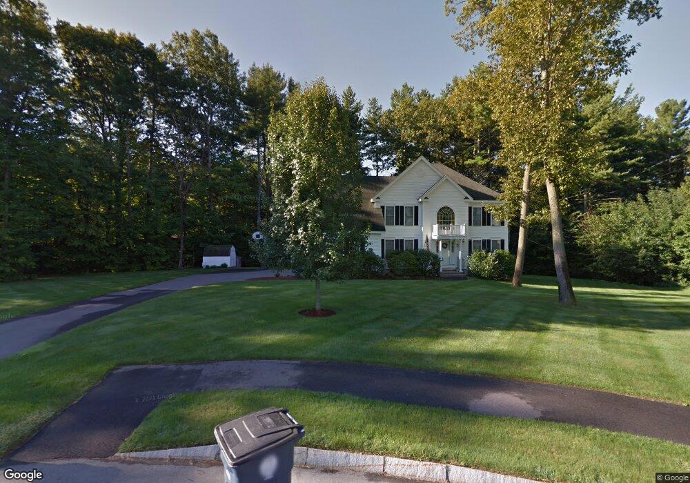
9 Owls Head Dr Nashua, NH 03063
Northwest Nashua NeighborhoodEstimated Value: $764,509 - $1,007,000
4
Beds
3
Baths
2,712
Sq Ft
$323/Sq Ft
Est. Value
About This Home
This home is located at 9 Owls Head Dr, Nashua, NH 03063 and is currently estimated at $876,627, approximately $323 per square foot. 9 Owls Head Dr is a home located in Hillsborough County with nearby schools including Charlotte Ave Elementary School, Pennichuck Middle School, and Nashua High School North.
Ownership History
Date
Name
Owned For
Owner Type
Purchase Details
Closed on
Feb 24, 2020
Sold by
Inzerillo Samuel and Inzerillo Jean M
Bought by
Inzerillo Ft and Inzerillo
Current Estimated Value
Purchase Details
Closed on
Jul 16, 2002
Sold by
Ashwood Dev Cos Inc
Bought by
Inzerillo Samuel and Inzerillo Jean M
Home Financials for this Owner
Home Financials are based on the most recent Mortgage that was taken out on this home.
Original Mortgage
$291,600
Interest Rate
6.79%
Mortgage Type
Purchase Money Mortgage
Create a Home Valuation Report for This Property
The Home Valuation Report is an in-depth analysis detailing your home's value as well as a comparison with similar homes in the area
Home Values in the Area
Average Home Value in this Area
Purchase History
| Date | Buyer | Sale Price | Title Company |
|---|---|---|---|
| Inzerillo Ft | -- | None Available | |
| Inzerillo Samuel | $364,500 | -- |
Source: Public Records
Mortgage History
| Date | Status | Borrower | Loan Amount |
|---|---|---|---|
| Previous Owner | Inzerillo Samuel | $220,000 | |
| Previous Owner | Inzerillo Samuel | $240,000 | |
| Previous Owner | Inzerillo Samuel | $100,000 | |
| Previous Owner | Inzerillo Samuel | $291,600 |
Source: Public Records
Tax History Compared to Growth
Tax History
| Year | Tax Paid | Tax Assessment Tax Assessment Total Assessment is a certain percentage of the fair market value that is determined by local assessors to be the total taxable value of land and additions on the property. | Land | Improvement |
|---|---|---|---|---|
| 2024 | $12,578 | $791,100 | $189,300 | $601,800 |
| 2023 | $11,966 | $656,400 | $151,400 | $505,000 |
| 2022 | $11,861 | $656,400 | $151,400 | $505,000 |
| 2021 | $10,115 | $435,600 | $111,000 | $324,600 |
| 2020 | $9,849 | $435,600 | $111,000 | $324,600 |
| 2019 | $9,435 | $433,600 | $111,000 | $322,600 |
| 2018 | $9,197 | $433,600 | $111,000 | $322,600 |
| 2017 | $10,662 | $413,400 | $118,200 | $295,200 |
| 2016 | $10,364 | $413,400 | $118,200 | $295,200 |
| 2015 | $10,141 | $413,400 | $118,200 | $295,200 |
| 2014 | $9,942 | $413,400 | $118,200 | $295,200 |
Source: Public Records
Map
Nearby Homes
- 26 Andover Down Unit 276
- 38 Highbridge Hill Rd Unit 186
- 66 Tinker Rd
- 5 Dumaine Ave Unit B
- 5 Dumaine Ave Unit N
- 75 Deerwood Dr Unit B
- 77 Deerwood Dr Unit E
- 218 Millwright Dr Unit 218
- 201 Millwright Dr
- 3 Roedean Dr Unit C-207
- 2 New Haven Dr Unit E303
- 123 Cannongate III
- 74 Profile Cir
- 47 Hanna Cir Unit 47
- 47 Hanna Cir
- 9 Cambridge Dr
- 7 Robert Dr
- 5 Chatfield Dr Unit U18
- 4 Jared Cir Unit U21
- 18 Swift Ln