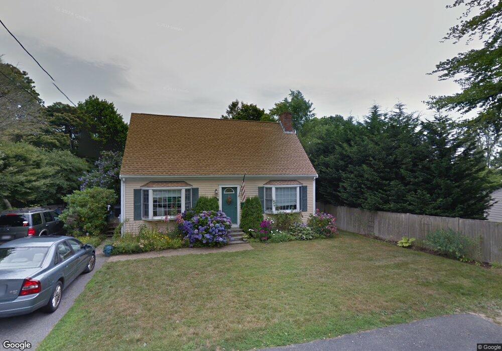
9 Shields St Newport, RI 02840
Fifth Ward NeighborhoodEstimated Value: $1,207,000 - $1,899,000
3
Beds
3
Baths
1,296
Sq Ft
$1,161/Sq Ft
Est. Value
About This Home
This home is located at 9 Shields St, Newport, RI 02840 and is currently estimated at $1,504,154, approximately $1,160 per square foot. 9 Shields St is a home located in Newport County with nearby schools including Rogers High School and St Michael's Country Day School.
Ownership History
Date
Name
Owned For
Owner Type
Purchase Details
Closed on
May 22, 1998
Sold by
Andrade Victor David and Andrade Marlene Karen
Bought by
Moore Joseph P and Moore Susan C
Current Estimated Value
Create a Home Valuation Report for This Property
The Home Valuation Report is an in-depth analysis detailing your home's value as well as a comparison with similar homes in the area
Home Values in the Area
Average Home Value in this Area
Purchase History
| Date | Buyer | Sale Price | Title Company |
|---|---|---|---|
| Moore Joseph P | $155,000 | -- |
Source: Public Records
Mortgage History
| Date | Status | Borrower | Loan Amount |
|---|---|---|---|
| Open | Moore Joseph P | $250,000 | |
| Closed | Moore Joseph P | $75,000 | |
| Closed | Moore Joseph P | $216,000 |
Source: Public Records
Tax History
| Year | Tax Paid | Tax Assessment Tax Assessment Total Assessment is a certain percentage of the fair market value that is determined by local assessors to be the total taxable value of land and additions on the property. | Land | Improvement |
|---|---|---|---|---|
| 2025 | $7,059 | $983,200 | $510,400 | $472,800 |
| 2024 | $6,853 | $983,200 | $510,400 | $472,800 |
| 2023 | $6,389 | $644,100 | $333,600 | $310,500 |
| 2022 | $6,190 | $644,100 | $333,600 | $310,500 |
| 2021 | $6,009 | $644,100 | $333,600 | $310,500 |
| 2020 | $5,401 | $525,400 | $251,300 | $274,100 |
| 2019 | $5,401 | $525,400 | $251,300 | $274,100 |
| 2018 | $5,249 | $525,400 | $251,300 | $274,100 |
| 2017 | $4,846 | $432,300 | $179,800 | $252,500 |
| 2016 | $4,725 | $432,300 | $179,800 | $252,500 |
| 2015 | $4,613 | $432,300 | $179,800 | $252,500 |
| 2014 | $5,064 | $419,900 | $152,900 | $267,000 |
Source: Public Records
Map
Nearby Homes
- 128 Ruggles Ave
- 63 Coggeshall Ave
- 70 Carroll Ave Unit 112
- 70 Carroll Ave Unit 510
- 73 Old Fort Rd Unit 75
- 6 Price's Cove Ave
- 39 Connection St
- 6 Sullivan St
- 66 Webster St Unit 9
- 57 Clinton St Unit 57C
- 59 Houston Ave
- 46 Chastellux Ave Unit M6
- 32 Houston Ave
- 421 Bellevue Ave Unit 3B
- 6 Sharon Ct
- 2 Harbor View Dr
- 11 Ocean Heights Rd
- 14 Lee Ave
- 27 Dean Ave
- 2 Perry St
- 21 Shields St Unit 23
- 11 Shields St
- 122 Ruggles Ave
- 29 Weatherly Ave
- 120 Ruggles Ave
- 10 Shields St
- 27 Weatherly Ave
- 124 Ruggles Ave
- 12 Shields St
- 126 Ruggles Ave
- 25 Weatherly Ave
- 13 Shields St
- 118 Ruggles Ave Unit 1E
- 118 Ruggles Ave Unit basement
- 118 Ruggles Ave Unit 1W
- 118 Ruggles Ave Unit 2W
- 118 Ruggles Ave Unit 2e
- 118 Ruggles Ave Unit 3
- 118 Ruggles Ave Unit 300
- 118 Ruggles Ave Unit 202
Your Personal Tour Guide
Ask me questions while you tour the home.