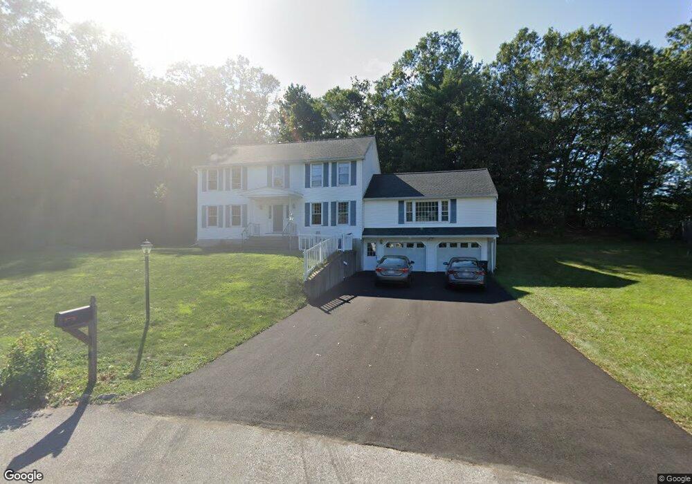
9 Sparta Way Andover, MA 01810
Estimated Value: $1,209,251 - $1,389,000
4
Beds
4
Baths
3,724
Sq Ft
$351/Sq Ft
Est. Value
About This Home
This home is located at 9 Sparta Way, Andover, MA 01810 and is currently estimated at $1,307,813, approximately $351 per square foot. 9 Sparta Way is a home located in Essex County with nearby schools including South Elementary School, Andover West Middle School, and Andover High School.
Ownership History
Date
Name
Owned For
Owner Type
Purchase Details
Closed on
Sep 15, 2003
Sold by
Deshpande Gururaj and Deshpande Jaishree
Bought by
Motwani Rajkumari S and Dewani Suresh
Current Estimated Value
Home Financials for this Owner
Home Financials are based on the most recent Mortgage that was taken out on this home.
Original Mortgage
$322,700
Interest Rate
6.22%
Mortgage Type
Purchase Money Mortgage
Purchase Details
Closed on
Aug 21, 1992
Sold by
Davidson Alfred B
Bought by
Deshpande Gururaj
Purchase Details
Closed on
Oct 30, 1987
Sold by
Spring Vly Dev Corp
Bought by
Davidson Alfred B
Create a Home Valuation Report for This Property
The Home Valuation Report is an in-depth analysis detailing your home's value as well as a comparison with similar homes in the area
Home Values in the Area
Average Home Value in this Area
Purchase History
| Date | Buyer | Sale Price | Title Company |
|---|---|---|---|
| Motwani Rajkumari S | $620,000 | -- | |
| Motwani Rajkumari S | $620,000 | -- | |
| Deshpande Gururaj | $299,000 | -- | |
| Deshpande Gururaj | $299,000 | -- | |
| Davidson Alfred B | $299,990 | -- |
Source: Public Records
Mortgage History
| Date | Status | Borrower | Loan Amount |
|---|---|---|---|
| Open | Davidson Alfred B | $225,000 | |
| Closed | Motwani Rajkumari S | $322,700 | |
| Previous Owner | Davidson Alfred B | $38,000 |
Source: Public Records
Tax History Compared to Growth
Tax History
| Year | Tax Paid | Tax Assessment Tax Assessment Total Assessment is a certain percentage of the fair market value that is determined by local assessors to be the total taxable value of land and additions on the property. | Land | Improvement |
|---|---|---|---|---|
| 2024 | $12,388 | $961,800 | $461,200 | $500,600 |
| 2023 | $11,655 | $853,200 | $394,400 | $458,800 |
| 2022 | $11,179 | $765,700 | $355,400 | $410,300 |
| 2021 | $10,737 | $702,200 | $323,300 | $378,900 |
| 2020 | $10,456 | $696,600 | $323,300 | $373,300 |
| 2019 | $10,559 | $691,500 | $323,300 | $368,200 |
| 2018 | $10,235 | $654,400 | $314,000 | $340,400 |
| 2017 | $9,828 | $647,400 | $307,600 | $339,800 |
| 2016 | $9,633 | $650,000 | $307,600 | $342,400 |
| 2015 | $9,464 | $632,200 | $307,600 | $324,600 |
Source: Public Records
Map
Nearby Homes