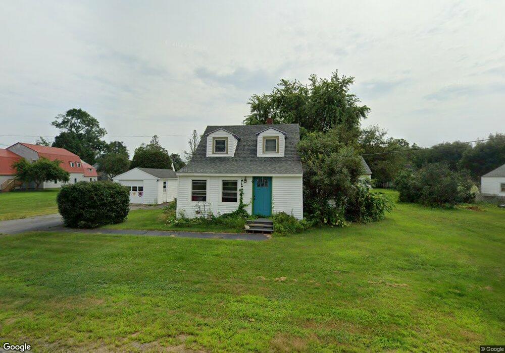
9 Sunset Ave North Berwick, ME 03906
Estimated Value: $248,000 - $341,000
2
Beds
1
Bath
600
Sq Ft
$505/Sq Ft
Est. Value
About This Home
This home is located at 9 Sunset Ave, North Berwick, ME 03906 and is currently estimated at $302,866, approximately $504 per square foot. 9 Sunset Ave is a home with nearby schools including Noble High School.
Ownership History
Date
Name
Owned For
Owner Type
Purchase Details
Closed on
Dec 18, 2020
Sold by
Fiel Andrew F
Bought by
Fiel Shilo A
Current Estimated Value
Home Financials for this Owner
Home Financials are based on the most recent Mortgage that was taken out on this home.
Original Mortgage
$130,000
Outstanding Balance
$115,739
Interest Rate
2.7%
Mortgage Type
Purchase Money Mortgage
Estimated Equity
$187,127
Purchase Details
Closed on
Mar 7, 2007
Sold by
Fiel Andrew F
Bought by
Fiel Andrew F and Fiel Shilo A
Home Financials for this Owner
Home Financials are based on the most recent Mortgage that was taken out on this home.
Original Mortgage
$138,000
Interest Rate
6.3%
Mortgage Type
Purchase Money Mortgage
Create a Home Valuation Report for This Property
The Home Valuation Report is an in-depth analysis detailing your home's value as well as a comparison with similar homes in the area
Home Values in the Area
Average Home Value in this Area
Purchase History
| Date | Buyer | Sale Price | Title Company |
|---|---|---|---|
| Fiel Shilo A | -- | None Available | |
| Fiel Andrew F | -- | -- |
Source: Public Records
Mortgage History
| Date | Status | Borrower | Loan Amount |
|---|---|---|---|
| Open | Fiel Shilo A | $130,000 | |
| Previous Owner | Fiel Andrew F | $138,000 |
Source: Public Records
Tax History Compared to Growth
Tax History
| Year | Tax Paid | Tax Assessment Tax Assessment Total Assessment is a certain percentage of the fair market value that is determined by local assessors to be the total taxable value of land and additions on the property. | Land | Improvement |
|---|---|---|---|---|
| 2024 | $2,627 | $262,700 | $103,700 | $159,000 |
| 2023 | $2,416 | $224,700 | $87,800 | $136,900 |
| 2022 | $1,960 | $175,800 | $76,000 | $99,800 |
| 2021 | $1,826 | $167,500 | $76,000 | $91,500 |
| 2020 | $4,714 | $151,800 | $68,900 | $82,900 |
| 2019 | $3,113 | $145,900 | $66,100 | $79,800 |
| 2018 | $1,554 | $140,500 | $66,100 | $74,400 |
| 2017 | $2,607 | $140,500 | $66,100 | $74,400 |
| 2016 | $1,770 | $140,500 | $66,100 | $74,400 |
| 2015 | $1,770 | $140,500 | $66,100 | $74,400 |
| 2013 | $1,749 | $140,500 | $66,100 | $74,400 |
Source: Public Records
Map
Nearby Homes
- 4 Puffin Ln Unit 13
- 42 Market St
- 38 High St
- Lot #5 Adams Bridge Rd
- 249 Wells St
- 331 Somersworth Rd
- 222 Lebanon Rd
- 30 Riverview Dr Unit D
- 15 Finson Rd
- 26 East Rd
- 0 Beech Ridge Rd Unit 1636541
- 8 Turkey St
- Lot A Butler Rd
- 13 Diamond Hill Rd
- 466 Lebanon Rd
- 100 Boyds Corner Rd
- 74 Rodier Rd
- 2 Harveys Way
- Lot 13 Laney Ln
- 58 Boyds Corner Rd