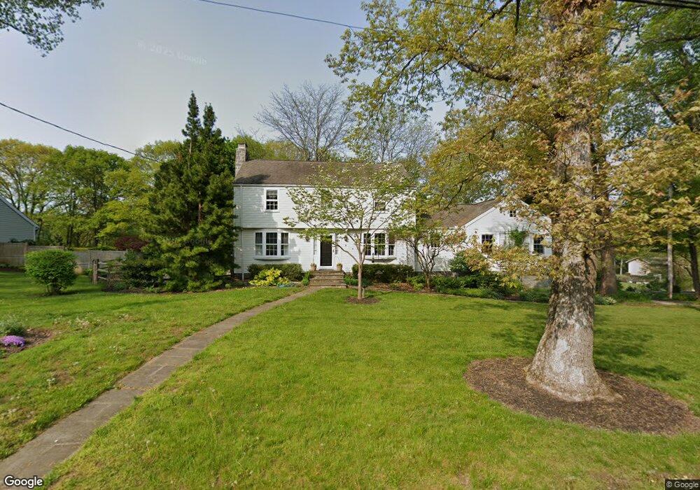
9 Sunset Rd Easton, CT 06612
Estimated Value: $894,000 - $1,004,000
3
Beds
3
Baths
2,774
Sq Ft
$339/Sq Ft
Est. Value
About This Home
This home is located at 9 Sunset Rd, Easton, CT 06612 and is currently estimated at $940,532, approximately $339 per square foot. 9 Sunset Rd is a home located in Fairfield County with nearby schools including Samuel Staples Elementary School, Helen Keller Middle School, and Joel Barlow High School.
Ownership History
Date
Name
Owned For
Owner Type
Purchase Details
Closed on
Dec 17, 1993
Sold by
Costello James and Costello Karen
Bought by
Mcdonald David and Cregren Sharon
Current Estimated Value
Home Financials for this Owner
Home Financials are based on the most recent Mortgage that was taken out on this home.
Original Mortgage
$203,150
Interest Rate
7.03%
Mortgage Type
Unknown
Purchase Details
Closed on
Aug 30, 1991
Sold by
Falso Althea
Bought by
Costello James G
Home Financials for this Owner
Home Financials are based on the most recent Mortgage that was taken out on this home.
Original Mortgage
$217,500
Interest Rate
9.44%
Mortgage Type
Purchase Money Mortgage
Create a Home Valuation Report for This Property
The Home Valuation Report is an in-depth analysis detailing your home's value as well as a comparison with similar homes in the area
Home Values in the Area
Average Home Value in this Area
Purchase History
| Date | Buyer | Sale Price | Title Company |
|---|---|---|---|
| Mcdonald David | $290,000 | -- | |
| Mcdonald David | $290,000 | -- | |
| Costello James G | $290,000 | -- |
Source: Public Records
Mortgage History
| Date | Status | Borrower | Loan Amount |
|---|---|---|---|
| Open | Costello James G | $200,000 | |
| Closed | Costello James G | $203,150 | |
| Previous Owner | Costello James G | $217,500 |
Source: Public Records
Tax History Compared to Growth
Tax History
| Year | Tax Paid | Tax Assessment Tax Assessment Total Assessment is a certain percentage of the fair market value that is determined by local assessors to be the total taxable value of land and additions on the property. | Land | Improvement |
|---|---|---|---|---|
| 2025 | $12,380 | $399,350 | $188,650 | $210,700 |
| 2024 | $11,797 | $399,350 | $188,650 | $210,700 |
| 2023 | $11,565 | $399,350 | $188,650 | $210,700 |
| 2022 | $11,358 | $399,350 | $188,650 | $210,700 |
| 2021 | $11,108 | $343,370 | $185,220 | $158,150 |
| 2020 | $10,644 | $343,370 | $185,220 | $158,150 |
| 2019 | $10,758 | $343,370 | $185,220 | $158,150 |
| 2018 | $10,775 | $343,370 | $185,220 | $158,150 |
| 2017 | $11,462 | $343,370 | $185,220 | $158,150 |
| 2016 | $10,523 | $341,540 | $188,650 | $152,890 |
| 2015 | $10,376 | $341,540 | $188,650 | $152,890 |
| 2014 | $10,212 | $341,540 | $188,650 | $152,890 |
Source: Public Records
Map
Nearby Homes
- 39 Sunset Rd
- 48 Sunset Rd
- 16 Manor Ln
- 305 Sport Hill Rd
- 38 Chester Rd
- 68 High Ridge Rd
- 63 Flat Rock Dr
- 35 Sturbridge Rd
- 93 Tersana Dr
- 83 Buck Hill Rd
- 32 Adirondack Trail
- 26 Wendy Rd
- 76 Hilary Cir Unit 76
- 42 Wendy Rd
- 178 Autumn Ridge Rd
- lot 194 Prospect Ave
- 71 Schiller Rd
- 132 Merrimac Dr
- 4293 Madison Ave
- 44 Lance Cir Unit 44