
Seller's Agent in 2026
Kyle D'Addieco
eXp Realty
(617) 592-9038
1 in this area
26 Total Sales

Estimated Value: $411,000 - $422,966
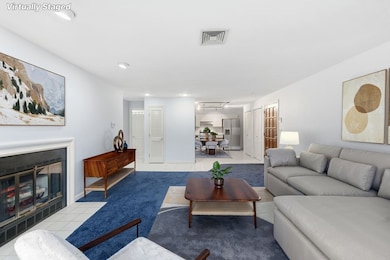
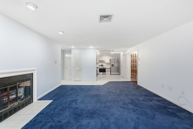
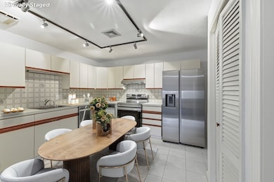
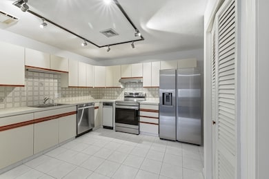
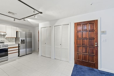
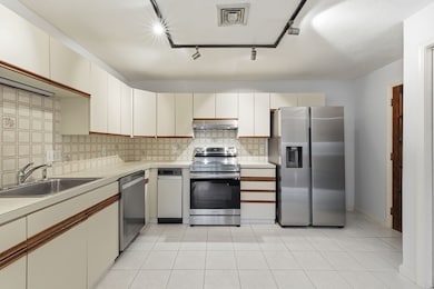
If you love wooded surroundings, morning walks, hiking, or biking—and want fast access to commuter routes—this is a home you don’t want to miss! Welcome to Hillview West: an immaculate, spacious, move-in-ready unit featuring new balcony doors, newer windows, a newer water heater, and stainless-steel appliances. The open-concept living/dining room offers an electric decorative fireplace perfect for cold season ambiance. The sliding door leads to a private balcony with peaceful wooded views. The bright eat-in kitchen offers abundance of cabinets and updated appliances. Two generous bedrooms with double closets and two baths add excellent flexibility. Enjoy in-unit laundry, extra storage, a deeded parking spot, guest parking, and a community pool and Jacuzzi. Minutes to shopping, dining, and steps from Breakheart Reservation’s 650+ acres of trails and summer swimming. Move right in!Open Houses: Sat & Sun 11:30–1 PM. Offers due Tue, Nov 25 at 1 PM.
Last Buyer's Agent
Aria Mathur
Lamacchia Realty, Inc.
| Date | Buyer | Sale Price | Title Company |
|---|---|---|---|
| Silva Jose | $415,000 | -- | |
| Connell Spencer | $350,000 | None Available | |
| Scanzillo Maria | -- | -- |
| Date | Status | Borrower | Loan Amount |
|---|---|---|---|
| Previous Owner | Connell Spencer | $280,000 |
| Date | Event | Price | List to Sale | Price per Sq Ft |
|---|---|---|---|---|
| 01/16/2026 01/16/26 | Sold | $415,000 | -3.5% | $352 / Sq Ft |
| 12/29/2025 12/29/25 | Pending | -- | -- | -- |
| 11/19/2025 11/19/25 | For Sale | $429,900 | -- | $365 / Sq Ft |
| Year | Tax Paid | Tax Assessment Tax Assessment Total Assessment is a certain percentage of the fair market value that is determined by local assessors to be the total taxable value of land and additions on the property. | Land | Improvement |
|---|---|---|---|---|
| 2025 | $4,129 | $386,600 | $0 | $386,600 |
| 2024 | $4,029 | $378,300 | $0 | $378,300 |
| 2023 | $3,549 | $315,200 | $0 | $315,200 |
| 2022 | $3,634 | $302,600 | $0 | $302,600 |
| 2021 | $3,653 | $296,000 | $0 | $296,000 |
| 2020 | $3,218 | $270,000 | $0 | $270,000 |
| 2019 | $3,030 | $248,800 | $0 | $248,800 |
| 2018 | $2,873 | $248,100 | $0 | $248,100 |
| 2017 | $3,067 | $254,500 | $0 | $254,500 |
| 2016 | $2,711 | $222,200 | $0 | $222,200 |
| 2015 | $2,671 | $222,200 | $0 | $222,200 |
| 2014 | $2,580 | $222,200 | $0 | $222,200 |
Seller's Agent in 2026
Kyle D'Addieco
eXp Realty
(617) 592-9038
1 in this area
26 Total Sales
A
Buyer's Agent in 2026
Aria Mathur
Lamacchia Realty, Inc.
Source: MLS Property Information Network (MLS PIN)
MLS Number: 73456420
APN: SAUG-000012D-000012-000011
Disclaimer: Certain information contained herein is derived from information provided by parties other than Homes.com. All information provided is deemed reliable, but is not guaranteed to be accurate and should be independently verified.
![]() The property listing data and information, or the Images, set forth herein were provided to MLS Property Information Network, Inc. from third party sources, including sellers, lessors and public records, and were compiled by MLS Property Information Network, Inc. The property listing data and information, and the Images, are for the personal, non-commercial use of consumers having a good faith interest in purchasing or leasing listed properties of the type displayed to them and may not be used for any purpose other than to identify prospective properties which such consumers may have a good faith interest in purchasing or leasing. MLS Property Information Network, Inc. and its subscribers disclaim any and all representations and warranties as to the accuracy of the property listing data and information, or as to the accuracy of any of the Images, set forth herein.
The property listing data and information, or the Images, set forth herein were provided to MLS Property Information Network, Inc. from third party sources, including sellers, lessors and public records, and were compiled by MLS Property Information Network, Inc. The property listing data and information, and the Images, are for the personal, non-commercial use of consumers having a good faith interest in purchasing or leasing listed properties of the type displayed to them and may not be used for any purpose other than to identify prospective properties which such consumers may have a good faith interest in purchasing or leasing. MLS Property Information Network, Inc. and its subscribers disclaim any and all representations and warranties as to the accuracy of the property listing data and information, or as to the accuracy of any of the Images, set forth herein.
Ask me questions while you tour the home.