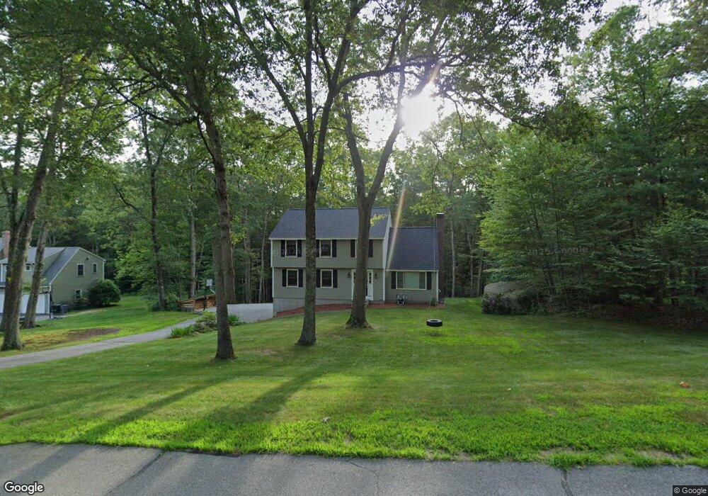
9 Windsor Dr Merrimack, NH 03054
Estimated Value: $599,367 - $640,000
4
Beds
3
Baths
2,084
Sq Ft
$297/Sq Ft
Est. Value
About This Home
This home is located at 9 Windsor Dr, Merrimack, NH 03054 and is currently estimated at $618,842, approximately $296 per square foot. 9 Windsor Dr is a home located in Hillsborough County with nearby schools including James Mastricola Elementary School, Merrimack Middle School, and James Mastricola Upper Elementary School.
Ownership History
Date
Name
Owned For
Owner Type
Purchase Details
Closed on
Jul 1, 2011
Sold by
Erlick Andrew J and Erlick Deborah J
Bought by
Gardner Lauren S and Chervincky Michael A
Current Estimated Value
Home Financials for this Owner
Home Financials are based on the most recent Mortgage that was taken out on this home.
Original Mortgage
$268,028
Interest Rate
4.62%
Mortgage Type
Purchase Money Mortgage
Create a Home Valuation Report for This Property
The Home Valuation Report is an in-depth analysis detailing your home's value as well as a comparison with similar homes in the area
Home Values in the Area
Average Home Value in this Area
Purchase History
Date | Buyer | Sale Price | Title Company |
---|---|---|---|
Gardner Lauren S | $275,000 | -- |
Source: Public Records
Mortgage History
Date | Status | Borrower | Loan Amount |
---|---|---|---|
Open | Erlick Andrew J | $228,000 | |
Closed | Erlick Andrew J | $268,028 | |
Previous Owner | Erlick Andrew J | $155,000 |
Source: Public Records
Tax History Compared to Growth
Tax History
Year | Tax Paid | Tax Assessment Tax Assessment Total Assessment is a certain percentage of the fair market value that is determined by local assessors to be the total taxable value of land and additions on the property. | Land | Improvement |
---|---|---|---|---|
2024 | $8,704 | $420,700 | $232,400 | $188,300 |
2023 | $8,148 | $418,900 | $232,400 | $186,500 |
2022 | $7,280 | $418,900 | $232,400 | $186,500 |
2021 | $7,193 | $418,900 | $232,400 | $186,500 |
2020 | $7,471 | $310,500 | $164,000 | $146,500 |
2019 | $7,492 | $310,500 | $164,000 | $146,500 |
2018 | $7,489 | $310,500 | $164,000 | $146,500 |
2017 | $7,256 | $310,500 | $164,000 | $146,500 |
2016 | $7,076 | $310,500 | $164,000 | $146,500 |
2015 | $7,231 | $292,500 | $152,600 | $139,900 |
2014 | $7,046 | $292,500 | $152,600 | $139,900 |
2013 | $6,987 | $292,200 | $152,600 | $139,600 |
Source: Public Records
Map
Nearby Homes
- 24 Longa Rd
- 54-A Parkhurst Rd
- 28B Shore Dr
- 11 Clark Island Rd
- 40 Captain Bannon Cir
- 14 Captain Bannon Cir
- 19 Captain Bannon Cir
- 4 Norton St
- 70 Broadway
- 27 Grafton Dr
- 9 Carriage Ln
- 8 Bowman Ct
- 32 Valleyview Dr
- 3 Powderhouse Rd
- 13 Holly Hill Dr
- 60 Colonel Daniels Dr
- 20 Holly Hill Dr
- 19 Turkey Hill Rd
- 3 Timber Ln
- 157 Bedford Rd
- 9 Windsor Dr
- 11 Windsor Dr
- 7 Windsor Dr
- 8 Windsor Dr
- 6 Windsor Dr
- 16 Windsor Dr
- 5 Windsor Dr
- 1 Westminster Ln
- 12 Greatstone Dr
- 14 1/2 Greatstone Dr
- 14 Greatstone Dr
- 14 Greatstone Dr
- 15 Windsor Dr
- 251 Baboosic Lake Rd
- 249 Baboosic Lake Rd
- 3 Windsor Dr
- 18 Windsor Dr
- 4 Westminster Ln
- 17 Windsor Dr
- 8 Greatstone Dr