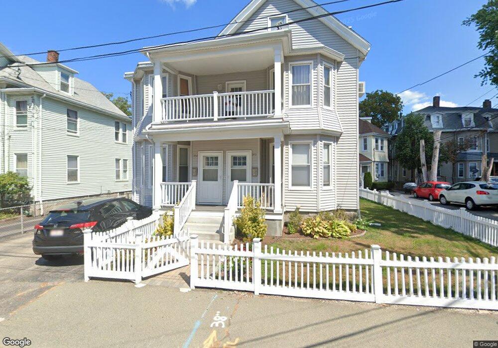
90 Robbins St Waltham, MA 02453
South Side NeighborhoodEstimated Value: $993,000 - $1,068,728
4
Beds
3
Baths
2,642
Sq Ft
$392/Sq Ft
Est. Value
About This Home
This home is located at 90 Robbins St, Waltham, MA 02453 and is currently estimated at $1,034,682, approximately $391 per square foot. 90 Robbins St is a home located in Middlesex County with nearby schools including Henry Whittemore Elementary School, John W. Mcdevitt Middle School, and Waltham Sr High School.
Ownership History
Date
Name
Owned For
Owner Type
Purchase Details
Closed on
Jan 5, 1999
Sold by
Rana Jayshree A and Rana Ashok M
Bought by
Burgos Jorge A
Current Estimated Value
Purchase Details
Closed on
Apr 14, 1995
Sold by
Perry Dorothy M Est
Bought by
Rana Jayshree A
Create a Home Valuation Report for This Property
The Home Valuation Report is an in-depth analysis detailing your home's value as well as a comparison with similar homes in the area
Home Values in the Area
Average Home Value in this Area
Purchase History
| Date | Buyer | Sale Price | Title Company |
|---|---|---|---|
| Burgos Jorge A | $275,000 | -- | |
| Rana Jayshree A | $70,000 | -- |
Source: Public Records
Mortgage History
| Date | Status | Borrower | Loan Amount |
|---|---|---|---|
| Open | Rana Jayshree A | $260,000 | |
| Closed | Rana Jayshree A | $50,000 | |
| Closed | Rana Jayshree A | $251,300 |
Source: Public Records
Tax History
| Year | Tax Paid | Tax Assessment Tax Assessment Total Assessment is a certain percentage of the fair market value that is determined by local assessors to be the total taxable value of land and additions on the property. | Land | Improvement |
|---|---|---|---|---|
| 2025 | $8,320 | $847,200 | $359,100 | $488,100 |
| 2024 | $7,691 | $797,800 | $359,100 | $438,700 |
| 2023 | $7,742 | $750,200 | $327,100 | $423,100 |
| 2022 | $7,839 | $703,700 | $298,700 | $405,000 |
| 2021 | $10,915 | $655,800 | $270,200 | $385,600 |
| 2020 | $7,347 | $614,800 | $256,000 | $358,800 |
| 2019 | $6,900 | $545,000 | $253,400 | $291,600 |
| 2018 | $6,226 | $493,700 | $234,700 | $259,000 |
| 2017 | $5,932 | $472,300 | $213,300 | $259,000 |
| 2016 | $5,476 | $447,400 | $188,400 | $259,000 |
| 2015 | $5,232 | $398,500 | $184,900 | $213,600 |
Source: Public Records
Map
Nearby Homes
- 133 Ash St Unit 3
- 31-37 Washington Ave
- 15 Alder St Unit 1
- 40 Dexter St
- 11 Derby St
- 24 Tolman St Unit 1
- 215 Ash St Unit 3
- 61 Hall St Unit 1
- 61 Hall St Unit 9
- 61 Hall St Unit 2
- 163-165 Chestnut St
- 74 Rumford Ave
- 312 Newton St Unit 1A
- 138 Myrtle St Unit 2
- 85 Crescent St
- 31 Hall St Unit 2
- 308 Newton St Unit 1
- 55-57 Crescent St
- 279-281 Ash St
- 105 Adams Ave
- 86 Robbins St
- 92 Robbins St
- 84 Robbins St
- 84 Robbins St Unit 2
- 82 1/2 Robbins St
- 82 Robbins St Unit 1 FIREPLACE/2 BATHS
- 82 Robbins St Unit 1
- 82 Robbins St
- 82 Robbins St Unit U
- 82 Robbins St
- 80 Robbins St Unit 3
- 80 Robbins St Unit 2
- 80 Robbins St Unit 3 HEATED
- 80 Robbins St Unit 1
- 80 Robbins St Unit 5
- 80 Robbins St
- 685 Moody St Unit 1
- 685 Moody St Unit 9
- 685 Moody St Unit 7
- 685 Moody St Unit 12
Your Personal Tour Guide
Ask me questions while you tour the home.