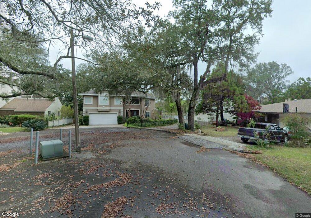
901 Sharon Point Cir Fort Walton Beach, FL 32547
Estimated Value: $722,000 - $898,471
3
Beds
3
Baths
3,409
Sq Ft
$232/Sq Ft
Est. Value
About This Home
This home is located at 901 Sharon Point Cir, Fort Walton Beach, FL 32547 and is currently estimated at $789,368, approximately $231 per square foot. 901 Sharon Point Cir is a home located in Okaloosa County with nearby schools including Shalimar Elementary School, W.C. Pryor Middle School, and Choctawhatchee Senior High School.
Ownership History
Date
Name
Owned For
Owner Type
Purchase Details
Closed on
Mar 27, 2024
Sold by
Brown Charles B and Brown Karen S
Bought by
Brown Living Trust and Brown
Current Estimated Value
Purchase Details
Closed on
Apr 21, 2011
Sold by
Kuhn William D and Kuhn Julie F
Bought by
Brown Charles B and Brown Karen S
Home Financials for this Owner
Home Financials are based on the most recent Mortgage that was taken out on this home.
Original Mortgage
$400,000
Interest Rate
4.85%
Mortgage Type
New Conventional
Purchase Details
Closed on
Sep 16, 2005
Sold by
Heusmann Michael D and Heusmann Stephani R
Bought by
Kuhn William D and Kuhn Julie F
Home Financials for this Owner
Home Financials are based on the most recent Mortgage that was taken out on this home.
Original Mortgage
$500,000
Interest Rate
5.62%
Mortgage Type
New Conventional
Create a Home Valuation Report for This Property
The Home Valuation Report is an in-depth analysis detailing your home's value as well as a comparison with similar homes in the area
Home Values in the Area
Average Home Value in this Area
Purchase History
| Date | Buyer | Sale Price | Title Company |
|---|---|---|---|
| Brown Living Trust | $100 | None Listed On Document | |
| Brown Charles B | $635,000 | Beach Title Services Llc | |
| Kuhn William D | $825,000 | -- |
Source: Public Records
Mortgage History
| Date | Status | Borrower | Loan Amount |
|---|---|---|---|
| Previous Owner | Brown Charles B | $400,000 | |
| Previous Owner | Kuhn William D | $500,000 |
Source: Public Records
Tax History Compared to Growth
Tax History
| Year | Tax Paid | Tax Assessment Tax Assessment Total Assessment is a certain percentage of the fair market value that is determined by local assessors to be the total taxable value of land and additions on the property. | Land | Improvement |
|---|---|---|---|---|
| 2024 | $5,788 | $526,774 | -- | -- |
| 2023 | $5,788 | $511,431 | $0 | $0 |
| 2022 | $5,652 | $496,535 | $0 | $0 |
| 2021 | $5,637 | $482,073 | $0 | $0 |
| 2020 | $5,594 | $475,417 | $0 | $0 |
| 2019 | $5,530 | $464,728 | $0 | $0 |
| 2018 | $5,483 | $456,063 | $0 | $0 |
| 2017 | $5,387 | $446,683 | $0 | $0 |
| 2016 | $5,235 | $436,946 | $0 | $0 |
| 2015 | $5,277 | $433,909 | $0 | $0 |
| 2014 | $5,240 | $430,465 | $0 | $0 |
Source: Public Records
Map
Nearby Homes
- 926 Lois St
- 603 Merioneth Dr NE
- 606 Merioneth Dr NE
- 604 Powell Dr NE
- 111 Troy Cir
- 603 Golf Course Dr NE
- 614 Merioneth Dr NE
- 2392 Cummings Dr
- 6 Chelsea Dr NW
- 526 Cheshire Ave NW
- 528 Cheshire Ave NW
- 16 Chelsea Dr NW
- 629 Merioneth Dr NE
- 94 Harris Rd NE Unit 1-4
- 60 Linwood Rd NW
- 8 Carlyle Ct NE
- 130 Scranton St
- 150 Beach Dr
- 138 Beach Dr
- 20 Linwood Rd NW
- 900 Sharon Point Cir
- 902 Sharon Point Cir
- 903 Sharon Point Cir
- 904 Sharon Point Cir
- 50 Bayou Dr
- 40 Bayou Dr
- 52 Bayou Dr
- 36 Bayou Dr
- 35 Bayou Dr
- 0 Bayou Dr
- 56 Bayou Dr
- 955 Zachary Ln
- 51 Bayou Dr
- 58 Bayou Dr
- 60 Bayou Dr Unit 16
- 60 Bayou Dr Unit 17
- 60 Bayou Dr Unit 20
- 60 Bayou Dr Unit 7
- 60 Bayou Dr Unit 18
- 60 Bayou Dr Unit 4