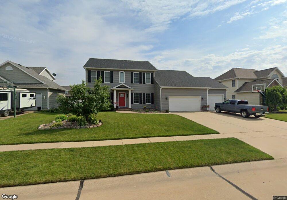
901 W Maple Ct Eldridge, IA 52748
Estimated Value: $480,000 - $488,271
4
Beds
4
Baths
2,744
Sq Ft
$176/Sq Ft
Est. Value
About This Home
This home is located at 901 W Maple Ct, Eldridge, IA 52748 and is currently estimated at $483,818, approximately $176 per square foot. 901 W Maple Ct is a home located in Scott County with nearby schools including Edward White Elementary School, North Scott Junior High School, and North Scott Senior High School.
Ownership History
Date
Name
Owned For
Owner Type
Purchase Details
Closed on
Apr 24, 2009
Sold by
Frerichs Marc E and Frerichs Carol M
Bought by
Covault Douglas B and Covault Shannon N
Current Estimated Value
Home Financials for this Owner
Home Financials are based on the most recent Mortgage that was taken out on this home.
Original Mortgage
$165,000
Outstanding Balance
$104,921
Interest Rate
5.05%
Mortgage Type
Purchase Money Mortgage
Estimated Equity
$378,897
Create a Home Valuation Report for This Property
The Home Valuation Report is an in-depth analysis detailing your home's value as well as a comparison with similar homes in the area
Home Values in the Area
Average Home Value in this Area
Purchase History
| Date | Buyer | Sale Price | Title Company |
|---|---|---|---|
| Covault Douglas B | $265,000 | None Available |
Source: Public Records
Mortgage History
| Date | Status | Borrower | Loan Amount |
|---|---|---|---|
| Open | Covault Douglas B | $165,000 |
Source: Public Records
Tax History
| Year | Tax Paid | Tax Assessment Tax Assessment Total Assessment is a certain percentage of the fair market value that is determined by local assessors to be the total taxable value of land and additions on the property. | Land | Improvement |
|---|---|---|---|---|
| 2025 | $5,358 | $475,600 | $78,000 | $397,600 |
| 2024 | $5,220 | $428,200 | $54,000 | $374,200 |
| 2023 | $5,174 | $428,200 | $54,000 | $374,200 |
| 2022 | $5,016 | $364,720 | $46,890 | $317,830 |
| 2021 | $5,016 | $364,720 | $46,890 | $317,830 |
| 2020 | $4,356 | $338,880 | $46,890 | $291,990 |
| 2019 | $4,422 | $302,690 | $38,370 | $264,320 |
| 2018 | $4,514 | $302,690 | $38,370 | $264,320 |
| 2017 | $1,684 | $302,690 | $38,370 | $264,320 |
| 2016 | $4,288 | $286,550 | $0 | $0 |
| 2015 | $4,288 | $274,140 | $0 | $0 |
| 2014 | $4,166 | $274,140 | $0 | $0 |
| 2013 | $4,090 | $0 | $0 | $0 |
| 2012 | -- | $276,650 | $38,370 | $238,280 |
Source: Public Records
Map
Nearby Homes
- 851 W Maple Ct
- 951 W Maple Ct
- 950 W Price St
- 900 W Price St
- 1000 W Price St
- 1001 W Maple Ct
- 900 W Maple Ct
- 821 W Maple Ct
- 950 W Maple Ct
- 850 W Maple Ct
- 1050 W Price St
- 651 Dammann Dr
- 1000 W Maple Ct
- 651 Dammann Dr
- 800 W Maple Ct
- 820 W Price St
- 1080 W Price St
- 1132 W Price St
- 1050 W Maple Ct
- 951 W Price St
Your Personal Tour Guide
Ask me questions while you tour the home.