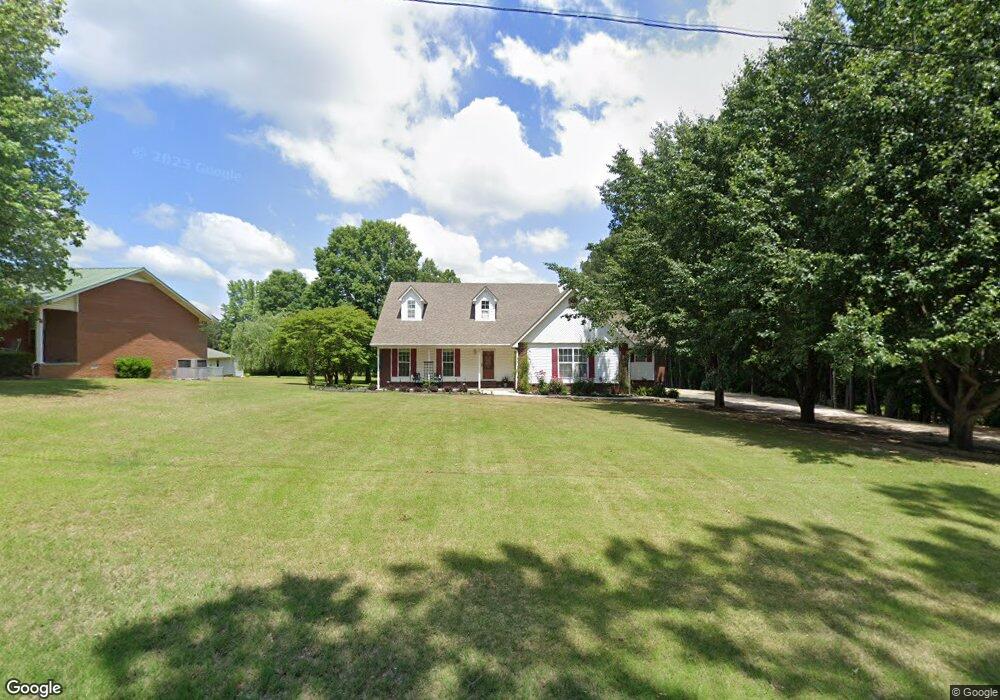
901 W Unity Rd Paragould, AR 72450
Estimated Value: $243,000 - $291,000
3
Beds
2
Baths
2,265
Sq Ft
$118/Sq Ft
Est. Value
About This Home
This home is located at 901 W Unity Rd, Paragould, AR 72450 and is currently estimated at $266,318, approximately $117 per square foot. 901 W Unity Rd is a home located in Greene County with nearby schools including Paragould High School and St. Mary's Catholic School & Preschool.
Ownership History
Date
Name
Owned For
Owner Type
Purchase Details
Closed on
Oct 2, 2025
Sold by
Ashby Tim and Ashby Judy
Bought by
Bowden Van Allen
Current Estimated Value
Purchase Details
Closed on
Jul 17, 2015
Sold by
Foster Matthew Lloyd and Foster Niki
Bought by
Federal National Mortgage Association
Purchase Details
Closed on
Sep 12, 2008
Sold by
Hall Ann and Rowlett Lorrie A
Bought by
Foster Matthew Loyd and Foster Niki
Home Financials for this Owner
Home Financials are based on the most recent Mortgage that was taken out on this home.
Original Mortgage
$133,876
Interest Rate
6.57%
Mortgage Type
New Conventional
Purchase Details
Closed on
Feb 27, 2004
Bought by
Trust
Purchase Details
Closed on
Sep 28, 1995
Bought by
Lynn and Ann Hall
Create a Home Valuation Report for This Property
The Home Valuation Report is an in-depth analysis detailing your home's value as well as a comparison with similar homes in the area
Home Values in the Area
Average Home Value in this Area
Purchase History
| Date | Buyer | Sale Price | Title Company |
|---|---|---|---|
| Bowden Van Allen | $20,000 | Priority Title | |
| Federal National Mortgage Association | $126,146 | None Available | |
| Foster Matthew Loyd | $127,000 | None Available | |
| Trust | -- | -- | |
| Lynn | $10,000 | -- |
Source: Public Records
Mortgage History
| Date | Status | Borrower | Loan Amount |
|---|---|---|---|
| Previous Owner | Foster Matthew Loyd | $133,876 |
Source: Public Records
Tax History Compared to Growth
Tax History
| Year | Tax Paid | Tax Assessment Tax Assessment Total Assessment is a certain percentage of the fair market value that is determined by local assessors to be the total taxable value of land and additions on the property. | Land | Improvement |
|---|---|---|---|---|
| 2024 | $1,696 | $45,980 | $3,300 | $42,680 |
| 2023 | $1,555 | $37,140 | $4,400 | $32,740 |
| 2022 | $1,180 | $37,140 | $4,400 | $32,740 |
| 2021 | $1,109 | $37,140 | $4,400 | $32,740 |
| 2020 | $1,413 | $30,700 | $3,200 | $27,500 |
| 2019 | $1,038 | $30,700 | $3,200 | $27,500 |
| 2018 | $1,063 | $30,700 | $3,200 | $27,500 |
| 2017 | $1,370 | $30,700 | $3,200 | $27,500 |
| 2016 | $1,370 | $30,700 | $3,200 | $27,500 |
| 2015 | $1,056 | $31,520 | $4,600 | $26,920 |
| 2014 | -- | $31,520 | $4,600 | $26,920 |
Source: Public Records
Map
Nearby Homes
- 3613 Purcell Rd
- 3505 Purcell Rd
- 811 Thorne Dr
- Tract 4 Greene 726 Rd
- Tract 3 Greene 726 Rd
- Tract 2 Greene 726 Rd
- Tract 1 Greene 726 Rd
- 000 Hwy 412 Byp Everett Dr
- 2903 Purcell Rd
- 2908 N 5th St
- 2802 N 4th St
- 807 Bard
- 3505 Sweet Gum St
- 0 Hwy 49s Unit 10124883
- 170 Granny Jean Ln
- 620 N St
- 620 N St
- 620 N 5th Lot 4 St
- 5 Acres Greene 726 Rd Tract 4
- 1507 S South 28 1 2 St
- 813 W Unity Rd
- 0 W Unity Rd
- 905 W Unity Rd
- 807 W Unity Rd
- 1001 W Unity Rd
- 810 W Unity Rd
- 801 W Unity Rd
- 717 W Unity Rd
- 1000 W Unity Rd
- 715 W Unity Rd
- 710 W Unity Rd
- 1009 W Unity Rd
- W Unity Rd
- 1008 W Unity Rd
- 80 W Unity Rd
- 80 acres W Unity Rd
- 3602 Purcell Rd
- 1012 W Unity Rd
- 1003 W Unity Rd
- 3510 Purcell Rd