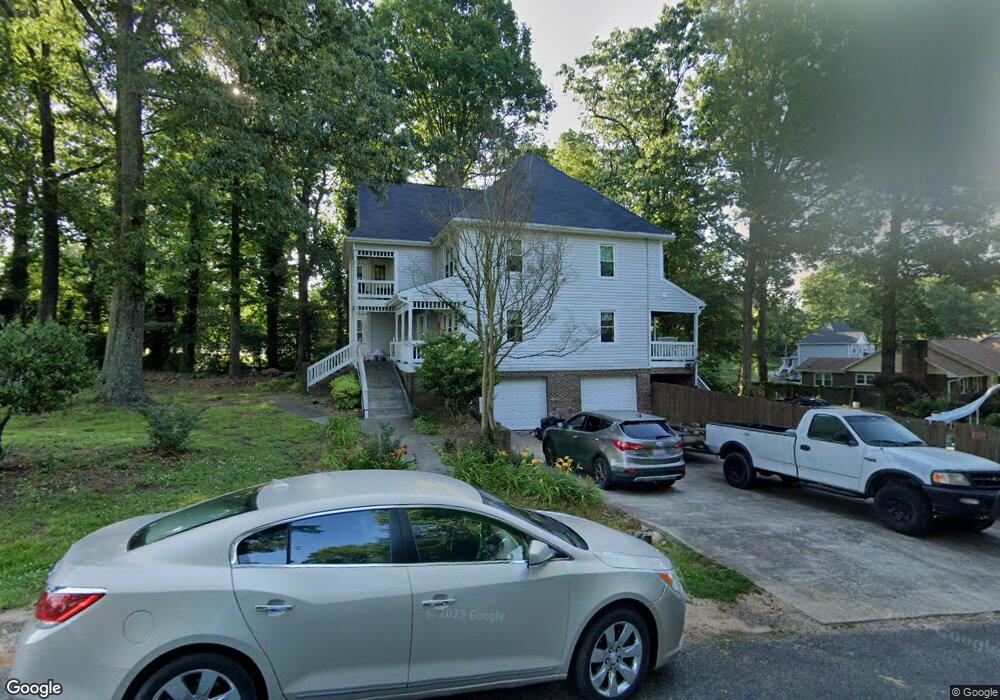
9010 Ronald Ave Lexington, NC 27295
Estimated Value: $490,000 - $529,000
5
Beds
5
Baths
3,600
Sq Ft
$142/Sq Ft
Est. Value
About This Home
This home is located at 9010 Ronald Ave, Lexington, NC 27295 and is currently estimated at $512,116, approximately $142 per square foot. 9010 Ronald Ave is a home located in Davidson County with nearby schools including Friedberg Elementary School, Oak Grove Middle School, and Oak Grove High School.
Ownership History
Date
Name
Owned For
Owner Type
Purchase Details
Closed on
May 31, 2006
Sold by
Hahn Timothy A and Hahn Pamela A
Bought by
Pagnozzi Paul and Pagnozzi Lori
Current Estimated Value
Home Financials for this Owner
Home Financials are based on the most recent Mortgage that was taken out on this home.
Original Mortgage
$179,999
Outstanding Balance
$110,486
Interest Rate
7.37%
Mortgage Type
Purchase Money Mortgage
Estimated Equity
$401,630
Purchase Details
Closed on
May 19, 2004
Sold by
Mcvey Jr Richard H and Mcvey Joan C
Bought by
Hahn Timothy A and Hahn Pamela S
Purchase Details
Closed on
Apr 1, 1993
Purchase Details
Closed on
Dec 1, 1990
Purchase Details
Closed on
Jun 1, 1990
Create a Home Valuation Report for This Property
The Home Valuation Report is an in-depth analysis detailing your home's value as well as a comparison with similar homes in the area
Home Values in the Area
Average Home Value in this Area
Purchase History
| Date | Buyer | Sale Price | Title Company |
|---|---|---|---|
| Pagnozzi Paul | $305,000 | None Available | |
| Hahn Timothy A | $242,500 | -- | |
| -- | $168,500 | -- | |
| -- | -- | -- | |
| -- | $17,000 | -- |
Source: Public Records
Mortgage History
| Date | Status | Borrower | Loan Amount |
|---|---|---|---|
| Open | Pagnozzi Paul | $179,999 |
Source: Public Records
Tax History Compared to Growth
Tax History
| Year | Tax Paid | Tax Assessment Tax Assessment Total Assessment is a certain percentage of the fair market value that is determined by local assessors to be the total taxable value of land and additions on the property. | Land | Improvement |
|---|---|---|---|---|
| 2025 | $2,372 | $364,890 | $0 | $0 |
| 2024 | $2,300 | $364,890 | $0 | $0 |
| 2023 | $2,300 | $364,890 | $0 | $0 |
| 2022 | $2,228 | $364,890 | $0 | $0 |
| 2021 | $2,228 | $364,890 | $0 | $0 |
| 2020 | $1,767 | $289,350 | $0 | $0 |
| 2019 | $1,794 | $289,350 | $0 | $0 |
| 2018 | $1,794 | $289,350 | $0 | $0 |
| 2017 | $1,794 | $289,350 | $0 | $0 |
| 2016 | $1,794 | $289,350 | $0 | $0 |
| 2015 | $1,794 | $289,350 | $0 | $0 |
| 2014 | $1,914 | $308,640 | $0 | $0 |
Source: Public Records
Map
Nearby Homes
- 249 Pipers Ridge E
- 167 Candytuft Ct
- 164 Candytuft Ct
- 156 Candytuft Ct
- 159 Candytuft Ct
- 281 Collingswood Dr
- 140 Candytuft Ct
- 151 Candytuft Ct
- 145 Candytuft Ct
- 400 Southlake Ct
- 618 Widaustin Dr
- 748 Widaustin Dr
- 395 Widaustin Dr
- 224 Old Doc Ct
- 429 Mendenhall Dr
- 411 Falcon Ln
- 9080 N Carolina Highway 150
- 403 Falcon Ln
- 397 Falcon Ln
- 418 Falcon Ln
- 561 Leonard Berrier Rd
- 9009 Ronald Ave
- 9006 Ronald Ave
- 533 Leonard Berrier Rd
- 9007 Ronald Ave
- 635 Leonard Berrier Rd
- 9004 Ronald Ave
- 9005 Ronald Ave
- 532 Leonard Berrier Rd
- 532 Leonard Berrier Rd
- 659 Leonard Berrier Rd
- 451 Leonard Berrier Rd
- 427 Leonard Berrier Rd
- 9002 Ronald Ave
- 656 Leonard Berrier Rd
- 274 & 252 Saddlebrook Ct
- 403 Leonard Berrier Rd
- 9001 Ronald Ave
- 9000 Ronald Ave
- 102 Wood Pointe Ct