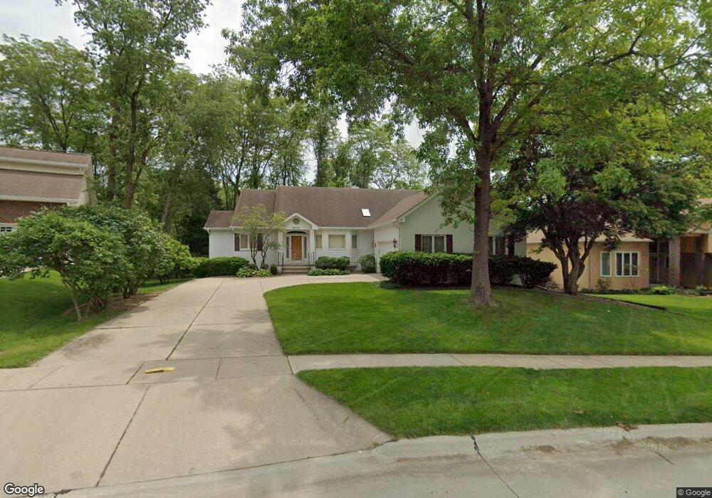
9012 Hammontree Dr Urbandale, IA 50322
Estimated Value: $404,287 - $467,000
2
Beds
3
Baths
2,225
Sq Ft
$194/Sq Ft
Est. Value
About This Home
This home is located at 9012 Hammontree Dr, Urbandale, IA 50322 and is currently estimated at $430,572, approximately $193 per square foot. 9012 Hammontree Dr is a home located in Polk County with nearby schools including Urbandale Middle School, Urbandale High School, and St Pius X School.
Ownership History
Date
Name
Owned For
Owner Type
Purchase Details
Closed on
Aug 29, 2025
Sold by
Weaver James L and Weaver Susan L
Bought by
Layden Taylor Anne
Current Estimated Value
Purchase Details
Closed on
Oct 20, 2000
Sold by
Fairley Doris N and Fairley Allan J
Bought by
Weaver James L and Weaver Susan L
Home Financials for this Owner
Home Financials are based on the most recent Mortgage that was taken out on this home.
Original Mortgage
$160,000
Interest Rate
7.9%
Create a Home Valuation Report for This Property
The Home Valuation Report is an in-depth analysis detailing your home's value as well as a comparison with similar homes in the area
Home Values in the Area
Average Home Value in this Area
Purchase History
| Date | Buyer | Sale Price | Title Company |
|---|---|---|---|
| Layden Taylor Anne | $424,000 | None Listed On Document | |
| Weaver James L | $256,500 | -- |
Source: Public Records
Mortgage History
| Date | Status | Borrower | Loan Amount |
|---|---|---|---|
| Previous Owner | Weaver James L | $160,000 |
Source: Public Records
Tax History Compared to Growth
Tax History
| Year | Tax Paid | Tax Assessment Tax Assessment Total Assessment is a certain percentage of the fair market value that is determined by local assessors to be the total taxable value of land and additions on the property. | Land | Improvement |
|---|---|---|---|---|
| 2025 | $6,452 | $423,900 | $95,200 | $328,700 |
| 2024 | $6,452 | $373,700 | $83,000 | $290,700 |
| 2023 | $6,650 | $373,700 | $83,000 | $290,700 |
| 2022 | $6,572 | $318,800 | $73,500 | $245,300 |
| 2021 | $6,478 | $318,800 | $73,500 | $245,300 |
| 2020 | $6,364 | $298,500 | $68,700 | $229,800 |
| 2019 | $6,010 | $298,500 | $68,700 | $229,800 |
| 2018 | $5,788 | $269,900 | $61,000 | $208,900 |
| 2017 | $5,412 | $269,900 | $61,000 | $208,900 |
| 2016 | $5,276 | $248,600 | $55,200 | $193,400 |
| 2015 | $5,276 | $248,600 | $55,200 | $193,400 |
| 2014 | $5,456 | $254,600 | $55,700 | $198,900 |
Source: Public Records
Map
Nearby Homes
- 4460 90th St
- 9107 Tanglewood Dr
- 4221 90th St
- 4473 89th St
- 8914 Valdez Dr
- 8626 Alpine Dr Unit D
- 4480 87th St Unit 10
- 8641 Alpine Dr Unit E
- 4529 91st St
- 8220 Twana Dr
- 4708 89th St
- Danbury Plan at Oakwood Haven
- Carson Plan at Oakwood Haven
- Gilmore Plan at Oakwood Haven
- Emerson Plan at Oakwood Haven
- Brighton Plan at Oakwood Haven
- Cambridge Plan at Oakwood Haven
- Aurora Plan at Oakwood Haven
- Fairfield Plan at Oakwood Haven
- 3957 92nd Dr
- 9018 Hammontree Dr
- 9008 Hammontree Dr
- 9024 Hammontree Dr
- 9013 Hammontree Dr
- 9004 Hammontree Dr
- 4450 91st St
- 9019 Hammontree Dr
- 9028 Hammontree Dr
- 8918 Townsend Ave
- 9025 Hammontree Dr
- 9100 Hammontree Dr
- 8819 Hammontree Cir
- 4454 91st St
- 9029 Hammontree Dr
- 8912 Townsend Ave
- 9104 Tanglewood Dr
- 8817 Hammontree Cir
- 8821 Hammontree Cir
- 9013 Aurora Ave
- 4451 91st St