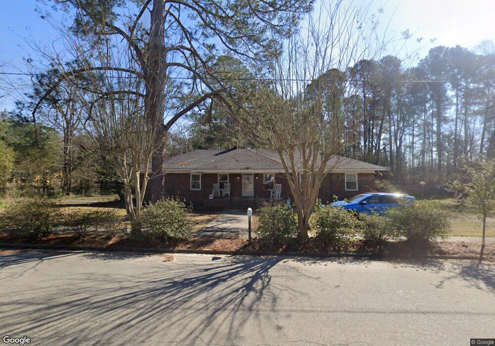
9012 Kennedy Bridge Rd Register, GA 30452
Estimated Value: $129,000 - $215,000
3
Beds
2
Baths
1,956
Sq Ft
$90/Sq Ft
Est. Value
About This Home
This home is located at 9012 Kennedy Bridge Rd, Register, GA 30452 and is currently estimated at $175,597, approximately $89 per square foot. 9012 Kennedy Bridge Rd is a home located in Bulloch County with nearby schools including Langston Chapel Elementary School, Statesboro High School, and Langston Chapel Middle School.
Ownership History
Date
Name
Owned For
Owner Type
Purchase Details
Closed on
Nov 19, 2019
Sold by
Rehman Hazrat
Bought by
Koch Walter F and Koch Faith
Current Estimated Value
Home Financials for this Owner
Home Financials are based on the most recent Mortgage that was taken out on this home.
Original Mortgage
$112,917
Outstanding Balance
$98,934
Interest Rate
3.75%
Mortgage Type
FHA
Estimated Equity
$76,664
Purchase Details
Closed on
Mar 12, 2018
Sold by
Davis Shirley Y
Bought by
Rehman Hazrat
Purchase Details
Closed on
Sep 1, 2000
Bought by
Yeomans William Albert
Create a Home Valuation Report for This Property
The Home Valuation Report is an in-depth analysis detailing your home's value as well as a comparison with similar homes in the area
Home Values in the Area
Average Home Value in this Area
Purchase History
| Date | Buyer | Sale Price | Title Company |
|---|---|---|---|
| Koch Walter F | $115,000 | -- | |
| Rehman Hazrat | $50,000 | -- | |
| Yeomans William Albert | -- | -- |
Source: Public Records
Mortgage History
| Date | Status | Borrower | Loan Amount |
|---|---|---|---|
| Open | Koch Walter F | $112,917 |
Source: Public Records
Tax History Compared to Growth
Tax History
| Year | Tax Paid | Tax Assessment Tax Assessment Total Assessment is a certain percentage of the fair market value that is determined by local assessors to be the total taxable value of land and additions on the property. | Land | Improvement |
|---|---|---|---|---|
| 2024 | $1,360 | $51,028 | $3,440 | $47,588 |
| 2023 | $1,383 | $47,668 | $3,440 | $44,228 |
| 2022 | $854 | $41,555 | $3,456 | $38,099 |
| 2021 | $714 | $34,246 | $3,456 | $30,790 |
| 2020 | $739 | $32,510 | $3,456 | $29,054 |
| 2019 | $514 | $22,488 | $3,456 | $19,032 |
| 2018 | $567 | $29,062 | $4,120 | $24,942 |
| 2017 | $555 | $28,303 | $4,120 | $24,183 |
| 2016 | $542 | $27,276 | $4,120 | $23,156 |
| 2015 | $653 | $26,440 | $4,120 | $22,320 |
| 2014 | $604 | $26,440 | $4,120 | $22,320 |
Source: Public Records
Map
Nearby Homes
- 26 Main St
- 0 Vera Ln Unit 10563963
- 19.13 ACRES Highway 301 N
- APPRX 34.2 ACRE Highway 301 N
- 0 Highway 301 S Unit 25510428
- 0 Moore Rd Unit 10546435
- 0 Moore Rd Unit 10547552
- 0 Twin Forks Rd Unit 24496768
- 0 Twin Forks Rd Unit 24496693
- 0 Twin Forks Rd Unit TRACT 1 10586434
- 0 Founders Cir Unit 10544083
- 0 Twin Forks Rd Unit TRACT 2 10586435
- 0 Twin Forks Rd Unit 25650888
- 0 Twin Forks Rd Unit 25650877
- 0 Twin Forks Rd Unit 25651132
- 0 Twin Forks Rd Unit 25641523
- 0 Twin Forks Rd Unit 25651129
- 0 Highway 46 Unit 10470505
- 0 Cypress Lake Rd Unit PARCEL D
- 0 Cypress Lake Rd Unit LOT E
- 9016 Kennedy Bridge Rd
- 9011 Kennedy Bridge Rd
- 2992 Ga Highway 46
- 1 Moore-Bird Ln
- 2 Main St
- 7 Moore Bird Ln
- 2785 Ga Highway 46
- 3 Moore-Bird Ln
- 8 Main St
- 3 Main St
- 5 Main St
- 3 Georgia 46
- Lot 3 Highway 46 Other
- 9 Moore Bird Ln
- 9 Moore-Bird Ln
- 2970 Georgia 46
- 2970 Ga Highway 46
- 11 Moore-Bird Ln
- 2969 Ga Highway 46
- 3295 Ga Highway 46