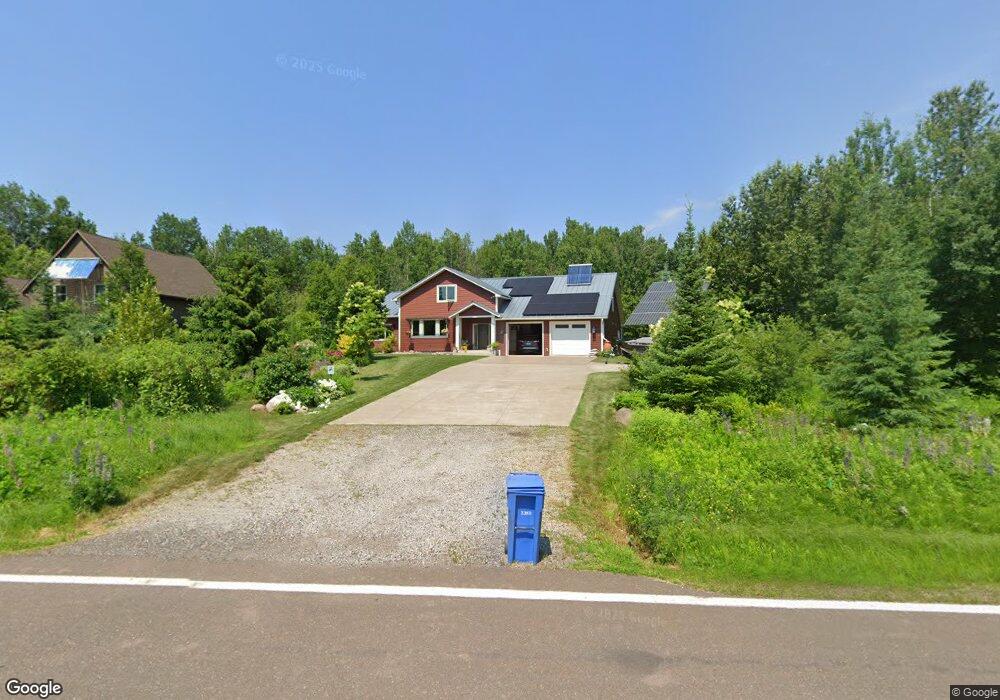
9013 E Superior St Duluth, MN 55804
North Shore NeighborhoodEstimated Value: $521,000 - $767,000
4
Beds
3
Baths
2,264
Sq Ft
$284/Sq Ft
Est. Value
About This Home
This home is located at 9013 E Superior St, Duluth, MN 55804 and is currently estimated at $642,846, approximately $283 per square foot. 9013 E Superior St is a home located in St. Louis County with nearby schools including Lester Park Elementary School, Ordean East Middle School, and East High School.
Ownership History
Date
Name
Owned For
Owner Type
Purchase Details
Closed on
Dec 16, 2005
Sold by
C & W Development Inc
Bought by
Johnson Mark J and Johnson Jo A
Current Estimated Value
Purchase Details
Closed on
Dec 15, 2005
Sold by
Kuznia Donald F and Kuznia Marie
Bought by
C & W Development Inc
Purchase Details
Closed on
Dec 6, 2004
Sold by
Rutford David C and Rutford Faith W
Bought by
Kuznia Donald F and Rutford David C
Create a Home Valuation Report for This Property
The Home Valuation Report is an in-depth analysis detailing your home's value as well as a comparison with similar homes in the area
Home Values in the Area
Average Home Value in this Area
Purchase History
| Date | Buyer | Sale Price | Title Company |
|---|---|---|---|
| Johnson Mark J | $33,751 | None Available | |
| C & W Development Inc | $10,000 | None Available | |
| Kuznia Donald F | -- | -- |
Source: Public Records
Tax History
| Year | Tax Paid | Tax Assessment Tax Assessment Total Assessment is a certain percentage of the fair market value that is determined by local assessors to be the total taxable value of land and additions on the property. | Land | Improvement |
|---|---|---|---|---|
| 2024 | $7,530 | $491,400 | $56,900 | $434,500 |
| 2023 | $7,530 | $388,200 | $72,800 | $315,400 |
| 2022 | $5,480 | $360,700 | $67,700 | $293,000 |
| 2021 | $5,474 | $296,800 | $55,500 | $241,300 |
| 2020 | $5,606 | $296,800 | $55,500 | $241,300 |
| 2019 | $5,876 | $296,800 | $55,500 | $241,300 |
| 2018 | $5,336 | $314,100 | $58,900 | $255,200 |
| 2017 | $5,612 | $301,400 | $57,100 | $244,300 |
| 2016 | $4,146 | $130,000 | $75,700 | $54,300 |
| 2015 | $3,253 | $274,300 | $47,800 | $226,500 |
| 2014 | $3,253 | $209,200 | $27,800 | $181,400 |
Source: Public Records
Map
Nearby Homes
- 0 Mcdonnell Rd
- XXXX Mcdonnell Rd
- 8353 Congdon Blvd
- xxxx Lakewood Rd Unit XXXX E. Superior St
- 50XX Lakewood Rd
- 5377 Mcquade Rd
- 5257 Greenwood Rd
- 5616 Mcquade Rd
- 5483 Lester River Rd
- 5570 Lester River Rd
- 5508 Nordling Rd
- 2597 Lauren Rd
- 5316 Oakley St
- 3325 Strand Rd
- 5211 Avondale St
- 4919 Oakley St
- 21 S 55th Ave E
- 5004 Wyoming St
- 3464 W Tischer Rd
- 6048 Lakewood Rd
- 9007 E Superior St
- 9019 E Superior St
- 9025 E Superior St
- 9031 E Superior St
- 8923 E Superior St
- x S Cant Rd N
- x S Cant-Road-n
- 55xn S Cant Rd
- 55xs S Cant Rd
- 8901 E Superior St
- 9101 E Superior St Unit address is approxima
- 5577 S Cant Rd
- 9127 E Superior St
- 9001 Congdon Blvd
- 8925 Congdon Blvd
- 9141 Congdon Blvd
- 9025 Congdon Blvd
- 8915 Congdon Blvd
- 9207 E Superior St
- 5101 S Cant Rd
Your Personal Tour Guide
Ask me questions while you tour the home.