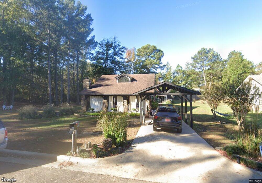
903 Daniel Ave Broken Bow, OK 74728
Estimated Value: $184,000 - $219,000
3
Beds
2
Baths
1,322
Sq Ft
$148/Sq Ft
Est. Value
About This Home
This home is located at 903 Daniel Ave, Broken Bow, OK 74728 and is currently estimated at $195,504, approximately $147 per square foot. 903 Daniel Ave is a home located in McCurtain County with nearby schools including Dierks Elementary School, Bennett Elementary School, and Rector Johnson Middle School.
Ownership History
Date
Name
Owned For
Owner Type
Purchase Details
Closed on
Sep 2, 2003
Sold by
Bbow Housing Authority
Bought by
Adams Sandra Jean
Current Estimated Value
Purchase Details
Closed on
Jul 3, 2003
Sold by
Scott Stephanie D
Bought by
B.Bow Housing Authority
Purchase Details
Closed on
Dec 10, 1998
Sold by
Housing Authority Of Bb
Bought by
Scott Stephanie D
Create a Home Valuation Report for This Property
The Home Valuation Report is an in-depth analysis detailing your home's value as well as a comparison with similar homes in the area
Home Values in the Area
Average Home Value in this Area
Purchase History
| Date | Buyer | Sale Price | Title Company |
|---|---|---|---|
| Adams Sandra Jean | $65,500 | -- | |
| B.Bow Housing Authority | -- | -- | |
| Scott Stephanie D | $61,500 | -- |
Source: Public Records
Tax History
| Year | Tax Paid | Tax Assessment Tax Assessment Total Assessment is a certain percentage of the fair market value that is determined by local assessors to be the total taxable value of land and additions on the property. | Land | Improvement |
|---|---|---|---|---|
| 2025 | $860 | $10,317 | $1,484 | $8,833 |
| 2023 | $690 | $8,310 | $1,100 | $7,210 |
| 2022 | $649 | $7,914 | $1,100 | $6,814 |
| 2021 | $638 | $7,914 | $1,100 | $6,814 |
| 2020 | $651 | $8,006 | $1,100 | $6,906 |
| 2019 | $572 | $8,005 | $1,100 | $6,905 |
| 2018 | $559 | $7,772 | $1,100 | $6,672 |
| 2017 | $545 | $7,546 | $1,100 | $6,446 |
| 2016 | $531 | $7,326 | $1,100 | $6,226 |
| 2015 | $543 | $7,326 | $1,100 | $6,226 |
| 2014 | $546 | $7,326 | $1,100 | $6,226 |
Source: Public Records
Map
Nearby Homes
- 713 E 11th St
- 0 E 11th St
- 303 E 10th St
- 901 Dierks St
- 1102 Morgan Ln
- 1007 Campbell St
- 606 Campbell St
- 811 N Broadway St
- 162 Green Briar Trail
- 214 Driftcast Rd
- 136 Charmed Ridge Ln
- 317 Sugar Pine Loop
- 60 Sunrise Trail
- 69 White Tail Cir
- 19 Berry Ct
- 226 Uphilly Trail
- 77 Green Briar Trail
- 11 Drift Cast Rd
- 200 Campbell St
- 316 N Broadway St
- 905 Daniel Ave
- 907 Daniel Ave
- 904 Norris Ave
- 902 Norris Ave
- 906 Norris Ave
- 906 Daniel Ave
- 908 Norris Ave
- 908 Daniel Ave
- 1001 Daniel Ave
- 1001 Daniel Ave
- 1002 Norris Ave
- 1002 Daniel Ave
- 903 Norris Ave
- 905 N Brooks St
- 901 N Brooks St
- 1003 Daniel Ave
- 801 N Brooks St
- 907 N Brooks St
- 907 Norris Ave
- 1004 Daniel St