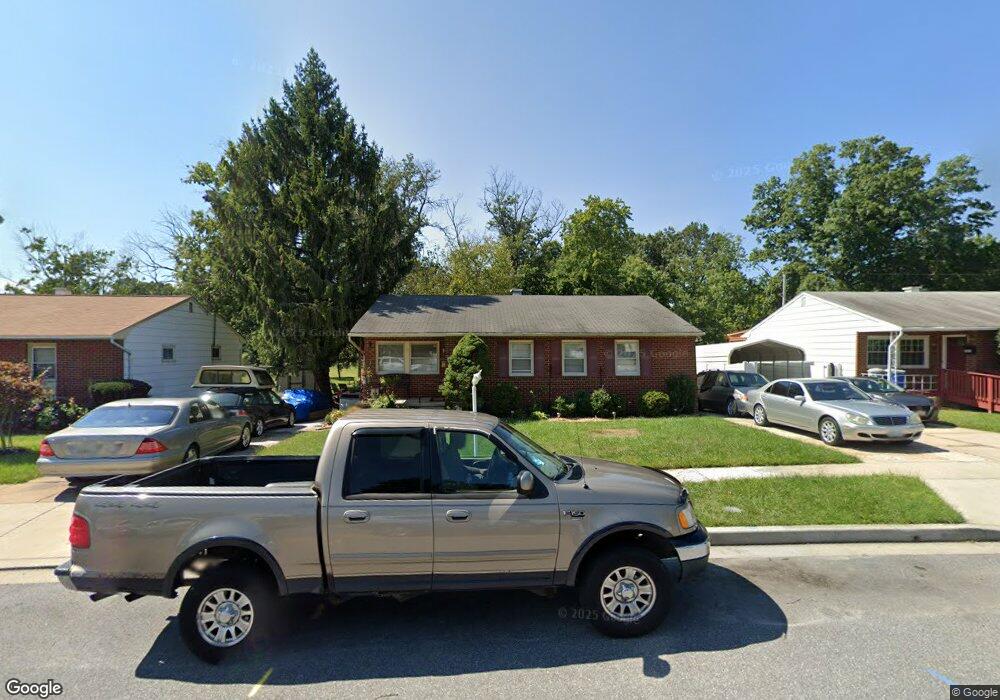
9031 Meadow Heights Rd Randallstown, MD 21133
Estimated Value: $314,762 - $413,000
--
Bed
2
Baths
1,270
Sq Ft
$284/Sq Ft
Est. Value
About This Home
This home is located at 9031 Meadow Heights Rd, Randallstown, MD 21133 and is currently estimated at $360,441, approximately $283 per square foot. 9031 Meadow Heights Rd is a home located in Baltimore County with nearby schools including Randallstown Elementary School, Deer Park Middle Magnet School, and Randallstown High School.
Ownership History
Date
Name
Owned For
Owner Type
Purchase Details
Closed on
Dec 15, 2018
Sold by
Ronald Keith E and Krumpe Kelly A
Bought by
Allen Jeannette L
Current Estimated Value
Purchase Details
Closed on
Jan 8, 1994
Sold by
Kushner Larry
Bought by
Tallie Paul D
Home Financials for this Owner
Home Financials are based on the most recent Mortgage that was taken out on this home.
Original Mortgage
$112,733
Interest Rate
7.23%
Create a Home Valuation Report for This Property
The Home Valuation Report is an in-depth analysis detailing your home's value as well as a comparison with similar homes in the area
Home Values in the Area
Average Home Value in this Area
Purchase History
| Date | Buyer | Sale Price | Title Company |
|---|---|---|---|
| Allen Jeannette L | -- | None Available | |
| Tallie Paul D | $112,000 | -- |
Source: Public Records
Mortgage History
| Date | Status | Borrower | Loan Amount |
|---|---|---|---|
| Previous Owner | Tallie Paul D | $112,733 |
Source: Public Records
Tax History Compared to Growth
Tax History
| Year | Tax Paid | Tax Assessment Tax Assessment Total Assessment is a certain percentage of the fair market value that is determined by local assessors to be the total taxable value of land and additions on the property. | Land | Improvement |
|---|---|---|---|---|
| 2025 | $4,393 | $289,233 | -- | -- |
| 2024 | $4,393 | $269,400 | $73,200 | $196,200 |
| 2023 | $2,011 | $256,833 | $0 | $0 |
| 2022 | $3,776 | $244,267 | $0 | $0 |
| 2021 | $3,678 | $231,700 | $55,200 | $176,500 |
| 2020 | $3,678 | $230,933 | $0 | $0 |
| 2019 | $3,443 | $230,167 | $0 | $0 |
| 2018 | $3,260 | $229,400 | $55,200 | $174,200 |
| 2017 | $3,037 | $208,933 | $0 | $0 |
| 2016 | $3,021 | $188,467 | $0 | $0 |
| 2015 | $3,021 | $168,000 | $0 | $0 |
| 2014 | $3,021 | $168,000 | $0 | $0 |
Source: Public Records
Map
Nearby Homes
- 9044 Allenswood Rd
- 3854 Terka Cir
- 3805 Terka Cir
- 8908 Meadow Heights Rd
- 9012 Allenswood Rd
- 3816 Cassandra Rd
- 3705 Allenswood Ct
- 9112 Meadow Heights Rd
- 20 Sunrise Ct
- 3907 Roxanne Rd
- 28 Sunrise Ct
- 1205/99 Winands Rd
- 9202 Samoset Rd
- 8806 Gilly Way Unit D
- 8802 Falcon Ridge Dr
- 4105 Kiwi Ct
- 4135 Brookside Oaks
- 9208A Liberty Rd
- 9210 Liberty Rd
- 3506 Bayer Ave
- 9033 Meadow Heights Rd
- 9029 Meadow Heights Rd
- 9035 Meadow Heights Rd
- 9027 Meadow Heights Rd
- 9032 Meadow Heights Rd
- 9024 Bruno Rd
- 9037 Meadow Heights Rd
- 9034 Meadow Heights Rd
- 9025 Meadow Heights Rd
- 9036 Meadow Heights Rd
- 9022 Bruno Rd
- 9039 Meadow Heights Rd
- 9023 Meadow Heights Rd
- 9038 Meadow Heights Rd
- 9025 Bruno Rd
- 9020 Bruno Rd
- 9041 Meadow Heights Rd
- 9046 Allenswood Rd
- 9040 Meadow Heights Rd
- 9018 Bruno Rd