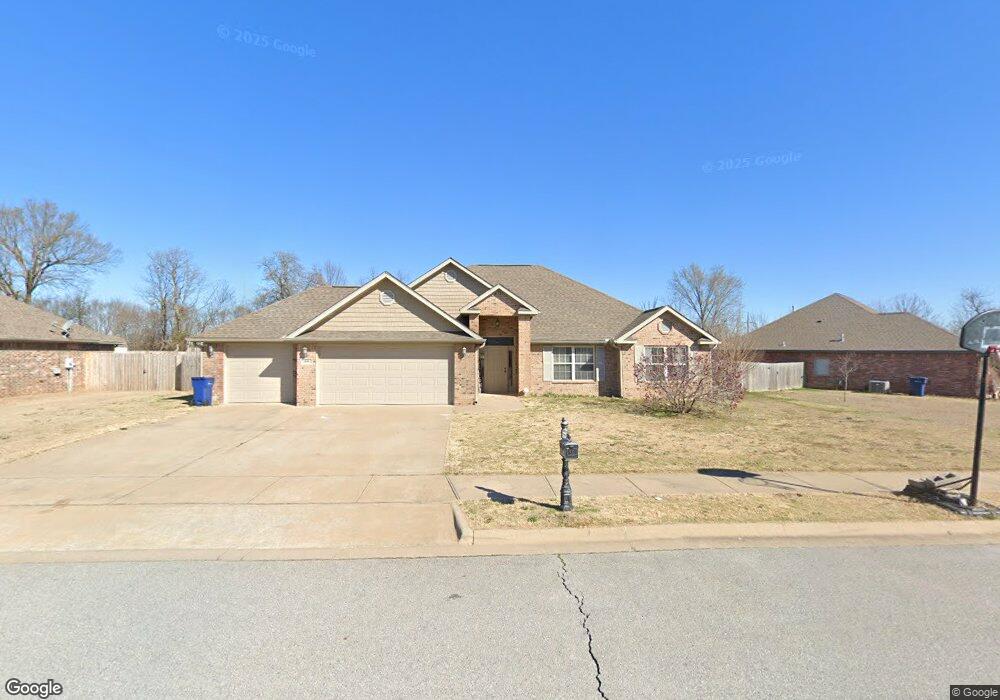
906 Carter Ct Siloam Springs, AR 72761
Estimated Value: $320,210 - $382,000
--
Bed
2
Baths
1,780
Sq Ft
$192/Sq Ft
Est. Value
About This Home
This home is located at 906 Carter Ct, Siloam Springs, AR 72761 and is currently estimated at $341,303, approximately $191 per square foot. 906 Carter Ct is a home located in Benton County with nearby schools including Northside Elementary School, Southside Elementary School, and Delbert Pete & Pat Allen Elementary School.
Ownership History
Date
Name
Owned For
Owner Type
Purchase Details
Closed on
Oct 27, 2006
Sold by
Kevin Gerlt Construction Inc
Bought by
Blankenship Scotty L and Blankenship Gina M
Current Estimated Value
Home Financials for this Owner
Home Financials are based on the most recent Mortgage that was taken out on this home.
Original Mortgage
$44,980
Interest Rate
6.28%
Mortgage Type
Stand Alone Second
Create a Home Valuation Report for This Property
The Home Valuation Report is an in-depth analysis detailing your home's value as well as a comparison with similar homes in the area
Home Values in the Area
Average Home Value in this Area
Purchase History
| Date | Buyer | Sale Price | Title Company |
|---|---|---|---|
| Blankenship Scotty L | $180,000 | Waco Title Company |
Source: Public Records
Mortgage History
| Date | Status | Borrower | Loan Amount |
|---|---|---|---|
| Closed | Blankenship Scotty L | $44,980 | |
| Open | Blankenship Scotty L | $134,920 |
Source: Public Records
Tax History Compared to Growth
Tax History
| Year | Tax Paid | Tax Assessment Tax Assessment Total Assessment is a certain percentage of the fair market value that is determined by local assessors to be the total taxable value of land and additions on the property. | Land | Improvement |
|---|---|---|---|---|
| 2025 | $2,674 | $55,559 | $10,400 | $45,159 |
| 2024 | $2,515 | $55,559 | $10,400 | $45,159 |
| 2023 | $2,287 | $39,700 | $8,000 | $31,700 |
| 2022 | $2,205 | $39,700 | $8,000 | $31,700 |
| 2021 | $1,634 | $39,700 | $8,000 | $31,700 |
| 2020 | $1,544 | $33,320 | $3,000 | $30,320 |
| 2019 | $1,544 | $33,320 | $3,000 | $30,320 |
| 2018 | $1,569 | $33,320 | $3,000 | $30,320 |
| 2017 | $1,433 | $33,320 | $3,000 | $30,320 |
| 2016 | $1,433 | $33,320 | $3,000 | $30,320 |
| 2015 | $1,644 | $28,550 | $5,000 | $23,550 |
| 2014 | $1,294 | $28,550 | $5,000 | $23,550 |
Source: Public Records
Map
Nearby Homes
- 8006 David Dr
- 509 Carter Rd
- 7004 David Dr
- 6008 David Dr
- 0 E Sugarloaf St
- 16013 N Airport Rd
- 15564 Airport Rd
- 19941 Edgewood Cir
- 925 S Canvasback Dr
- 920 S Canvasback Dr
- 1729-4 Plan at
- 820 S Parrot Ln
- 824 S Parrot Ln
- 4108 E Razorbill Dr
- 3605 N Marian St
- 0 Old Highway 68 Unit 25340983
- 19372 Old Highway 68 E
- 813 S Katlyn Dr
- 14987 S Highway 59
- 0 Bill Young Rd Unit 21090656
- 904 Carter Ct
- 908 Carter Ct
- 808 Carter Ct
- 905 Carter Ct
- 907 Carter Ct
- 903 Carter Ct
- 1005 Carter Ct
- 809 Carter Ct
- 806 Carter Ct
- 1003 Carter Ct
- 9003 Overland Rd
- 8007 Overland Rd
- 8005 Overland Rd
- 9005 Overland Rd
- 8005 Overland Dr
- 807 Carter Ct
- 8003 Overland Rd
- 9005 Overland Dr
- 8003 Overland Dr
- 9007 Overland Rd