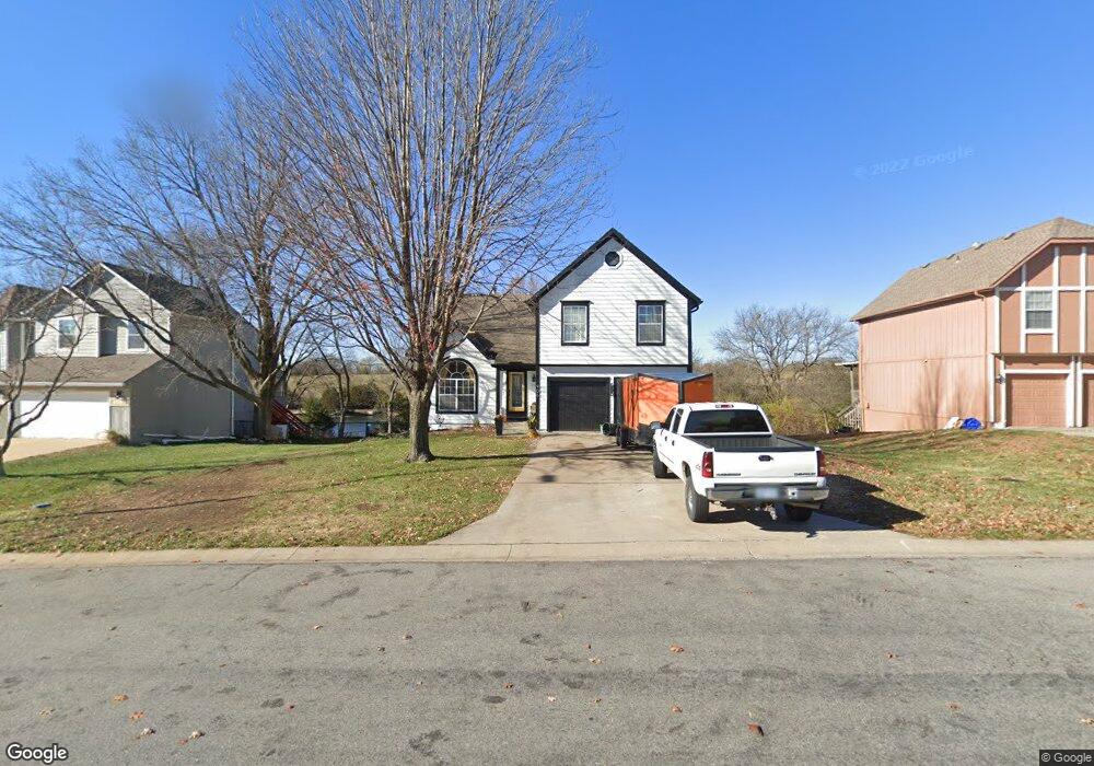
906 S 132nd St Bonner Springs, KS 66012
Estimated Value: $344,000 - $389,000
3
Beds
3
Baths
1,897
Sq Ft
$194/Sq Ft
Est. Value
About This Home
This home is located at 906 S 132nd St, Bonner Springs, KS 66012 and is currently estimated at $367,859, approximately $193 per square foot. 906 S 132nd St is a home located in Wyandotte County with nearby schools including Robert E Clark Middle School and Bonner Springs High School.
Ownership History
Date
Name
Owned For
Owner Type
Purchase Details
Closed on
Mar 11, 2022
Sold by
Reece Joseph V
Bought by
Reece Joseph V and Hull Sandra L
Current Estimated Value
Purchase Details
Closed on
Mar 31, 2021
Sold by
Ashford David H
Bought by
Reece Joseph V
Home Financials for this Owner
Home Financials are based on the most recent Mortgage that was taken out on this home.
Original Mortgage
$160,000
Interest Rate
2.8%
Mortgage Type
New Conventional
Purchase Details
Closed on
Apr 28, 2010
Sold by
Dunham Barbara L
Bought by
Ashford David H
Create a Home Valuation Report for This Property
The Home Valuation Report is an in-depth analysis detailing your home's value as well as a comparison with similar homes in the area
Home Values in the Area
Average Home Value in this Area
Purchase History
| Date | Buyer | Sale Price | Title Company |
|---|---|---|---|
| Reece Joseph V | -- | Secured Title Of Kansas City | |
| Reece Joseph V | -- | Secured Title Of Kansas City | |
| Ashford David H | -- | Kansas Secured Title |
Source: Public Records
Mortgage History
| Date | Status | Borrower | Loan Amount |
|---|---|---|---|
| Previous Owner | Reece Joseph V | $160,000 |
Source: Public Records
Tax History Compared to Growth
Tax History
| Year | Tax Paid | Tax Assessment Tax Assessment Total Assessment is a certain percentage of the fair market value that is determined by local assessors to be the total taxable value of land and additions on the property. | Land | Improvement |
|---|---|---|---|---|
| 2024 | $5,053 | $34,707 | $5,671 | $29,036 |
| 2023 | $4,276 | $27,615 | $5,095 | $22,520 |
| 2022 | $3,930 | $25,104 | $4,672 | $20,432 |
| 2021 | $4,288 | $25,757 | $3,904 | $21,853 |
| 2020 | $4,143 | $25,008 | $3,335 | $21,673 |
| 2019 | $3,981 | $23,817 | $3,059 | $20,758 |
| 2018 | $3,758 | $22,793 | $3,425 | $19,368 |
| 2017 | $3,530 | $21,804 | $3,425 | $18,379 |
| 2016 | $3,229 | $19,975 | $3,425 | $16,550 |
| 2015 | $3,232 | $19,975 | $3,485 | $16,490 |
| 2014 | $2,852 | $19,583 | $3,485 | $16,098 |
Source: Public Records
Map
Nearby Homes
- 700 S Deerfield Dr
- 926 S 130th Street Access Rd
- 13285 Richland Ave
- 13286 Richland Ave
- 13337 Metropolitan Ave
- 13287 Davis Ave
- 13299 Davis Ave
- 13295 Davis Ave
- 13313 Davis Ave
- 485 S 137th Place
- 636 Sheidley Ave
- 610 N Nettleton Ave
- 1801 S 136th St
- 13920 Kansas Ave
- 13627 Barber Ave
- 13742 Elmwood Ave
- 13663 Barber Ave
- 520 Linda Ln
- 419 Allcut Ave
- 452 Park Dr