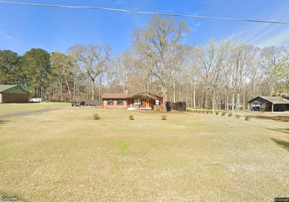
906 Vernon Ferry Rd Lagrange, GA 30240
Estimated Value: $174,000 - $246,000
3
Beds
2
Baths
1,566
Sq Ft
$140/Sq Ft
Est. Value
About This Home
This home is located at 906 Vernon Ferry Rd, Lagrange, GA 30240 and is currently estimated at $218,595, approximately $139 per square foot. 906 Vernon Ferry Rd is a home located in Troup County with nearby schools including Ethel W. Kight Elementary School, Hollis Hand Elementary School, and Franklin Forest Elementary School.
Ownership History
Date
Name
Owned For
Owner Type
Purchase Details
Closed on
Apr 25, 1977
Sold by
Edgar L Williamson
Bought by
Adams Kenneth D and Adams Nancy W
Current Estimated Value
Purchase Details
Closed on
Feb 25, 1977
Sold by
Mallory E
Bought by
Edgar L Williamson
Purchase Details
Closed on
Nov 18, 1976
Sold by
Ray Adams
Bought by
Mallory E
Purchase Details
Closed on
Oct 28, 1975
Bought by
Ray Adams
Create a Home Valuation Report for This Property
The Home Valuation Report is an in-depth analysis detailing your home's value as well as a comparison with similar homes in the area
Purchase History
| Date | Buyer | Sale Price | Title Company |
|---|---|---|---|
| Adams Kenneth D | $43,700 | -- | |
| Edgar L Williamson | -- | -- | |
| Mallory E | $5,000 | -- | |
| Ray Adams | -- | -- |
Source: Public Records
Tax History
| Year | Tax Paid | Tax Assessment Tax Assessment Total Assessment is a certain percentage of the fair market value that is determined by local assessors to be the total taxable value of land and additions on the property. | Land | Improvement |
|---|---|---|---|---|
| 2025 | $827 | $61,520 | $14,680 | $46,840 |
| 2024 | $719 | $55,400 | $14,680 | $40,720 |
| 2023 | $240 | $51,880 | $10,480 | $41,400 |
| 2022 | $537 | $47,840 | $8,400 | $39,440 |
| 2021 | $510 | $45,628 | $8,400 | $37,228 |
| 2020 | $1,076 | $45,628 | $8,400 | $37,228 |
| 2019 | $994 | $42,920 | $8,400 | $34,520 |
| 2018 | $942 | $41,192 | $8,400 | $32,792 |
| 2017 | $942 | $41,192 | $8,400 | $32,792 |
| 2016 | $996 | $42,972 | $8,400 | $34,572 |
| 2015 | $642 | $31,217 | $4,800 | $26,417 |
| 2014 | $600 | $29,826 | $4,800 | $25,026 |
| 2013 | -- | $31,222 | $4,800 | $26,422 |
Source: Public Records
Map
Nearby Homes
- 709 Vernon Ferry Rd
- 213 Linda Ln
- 129 Angela East Dr
- 4.51 ACRES Whatley Rd N
- 0 Deming St Unit 10550189
- 0 Salem Rd Tract 2 Unit 10675187
- 104 Dogwood Point
- 110 Thomas Dr
- 1017 Riverside Dr
- 4004 White Oak Ln
- 98 Hearn Rd
- 40 River Point Dr
- 16 River Point Dr
- 474 Newton Rd
- 113 Colonial Ct
- 101 Ivy Springs Dr
- 311 Cumberland Dr
- 203 Shawnee Dr
- 104 Independence Ct
- 245 Teaver Rd
- 920 Vernon Ferry Rd
- 892 Vernon Ferry Rd
- 936 Vernon Ferry Rd
- 909 Vernon Ferry Rd
- 895 Vernon Ferry Rd
- 923 Vernon Ferry Rd
- 880 Vernon Ferry Rd
- 868 Vernon Ferry Rd
- 3910 Roanoke Rd
- 104 Linda Ln
- 106 Linda Ln
- 865 Vernon Ferry Rd
- 3924 Roanoke Rd
- 108 Linda Ln
- 949 Vernon Ferry Rd
- 103 Paddle Wheel Dr
- 102 Linda Ln
- 105 Paddle Wheel Dr
- 854 Vernon Ferry Rd Unit TR 37
- 854 Vernon Ferry Rd
Your Personal Tour Guide
Ask me questions while you tour the home.