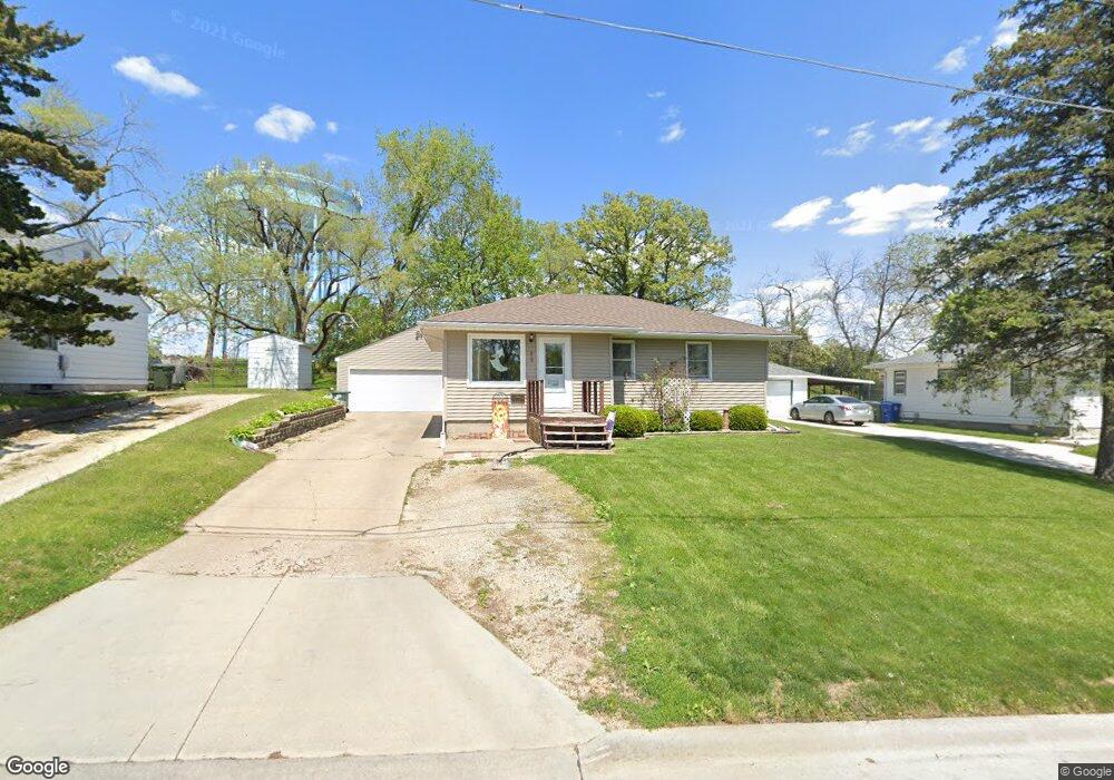
909 Alabar Ave Waterloo, IA 50701
Alabar Hills NeighborhoodEstimated Value: $150,000 - $175,877
3
Beds
1
Bath
1,480
Sq Ft
$109/Sq Ft
Est. Value
About This Home
This home is located at 909 Alabar Ave, Waterloo, IA 50701 and is currently estimated at $161,219, approximately $108 per square foot. 909 Alabar Ave is a home located in Black Hawk County with nearby schools including Becker Elementary School, Central Middle School, and West High School.
Ownership History
Date
Name
Owned For
Owner Type
Purchase Details
Closed on
Apr 1, 2011
Sold by
Koehn Michelle Lee and Koehn Keith Martin
Bought by
Bullerman Steven T and Buck Barbara Ann
Current Estimated Value
Home Financials for this Owner
Home Financials are based on the most recent Mortgage that was taken out on this home.
Original Mortgage
$97,375
Outstanding Balance
$67,533
Interest Rate
4.99%
Mortgage Type
New Conventional
Estimated Equity
$93,686
Create a Home Valuation Report for This Property
The Home Valuation Report is an in-depth analysis detailing your home's value as well as a comparison with similar homes in the area
Home Values in the Area
Average Home Value in this Area
Purchase History
| Date | Buyer | Sale Price | Title Company |
|---|---|---|---|
| Bullerman Steven T | $102,500 | None Available |
Source: Public Records
Mortgage History
| Date | Status | Borrower | Loan Amount |
|---|---|---|---|
| Open | Bullerman Steven T | $97,375 |
Source: Public Records
Tax History Compared to Growth
Tax History
| Year | Tax Paid | Tax Assessment Tax Assessment Total Assessment is a certain percentage of the fair market value that is determined by local assessors to be the total taxable value of land and additions on the property. | Land | Improvement |
|---|---|---|---|---|
| 2025 | $2,716 | $149,930 | $17,970 | $131,960 |
| 2024 | $2,716 | $135,440 | $17,970 | $117,470 |
| 2023 | $2,310 | $135,440 | $17,970 | $117,470 |
| 2022 | $2,246 | $114,030 | $17,970 | $96,060 |
| 2021 | $2,138 | $114,030 | $17,970 | $96,060 |
| 2020 | $2,082 | $102,260 | $17,970 | $84,290 |
| 2019 | $2,082 | $102,260 | $17,970 | $84,290 |
| 2018 | $2,086 | $102,260 | $17,970 | $84,290 |
| 2017 | $2,152 | $102,260 | $17,970 | $84,290 |
| 2016 | $2,122 | $102,260 | $17,970 | $84,290 |
| 2015 | $2,122 | $102,260 | $17,970 | $84,290 |
| 2014 | $2,164 | $102,260 | $17,970 | $84,290 |
Source: Public Records
Map
Nearby Homes
- 915 Alabar Ave
- 1742 Sager Ave
- 819 Hanna Blvd
- 1114 Eleanor Dr
- 1269 Scott Ave
- 2621 University Ave
- 1221 Downing Ave
- 400 Woodbridge St
- 1107 Downing Ave
- 320 Valley Rd
- 1726 Huntington Rd
- 2320 University Ave
- 0 Bergen Dr
- 1016 Evergreen Ave
- 102 Bergen Dr
- 104 Bergen Dr
- 1108 Maynard Ave
- 724 Kirkwood Ave
- 211 Auburn St
- 114 Hanna Blvd
- 901 Alabar Ave
- 927 Alabar Ave
- 1001 Littlefield Rd
- 934 Littlefield Rd
- 916 Alabar Ave
- 940 Littlefield Rd
- 924 Alabar Ave
- 1017 Littlefield Rd
- 1726 Flower St
- 1701 Flower St
- 1025 Littlefield Rd
- 1010 Alabar Ave
- 1715 Flower St
- 3128 University Ave
- 1018 Linbud Ln
- 1031 Littlefield Rd
- 1727 Flower St
- 3253 University Ave
- 3253 University Ave Unit D
- 3253 University Ave Unit B