
J
Seller's Agent in 2025
Jean Schiffmann
Bayview Real Estate
(508) 776-0868
5 in this area
10 Total Sales
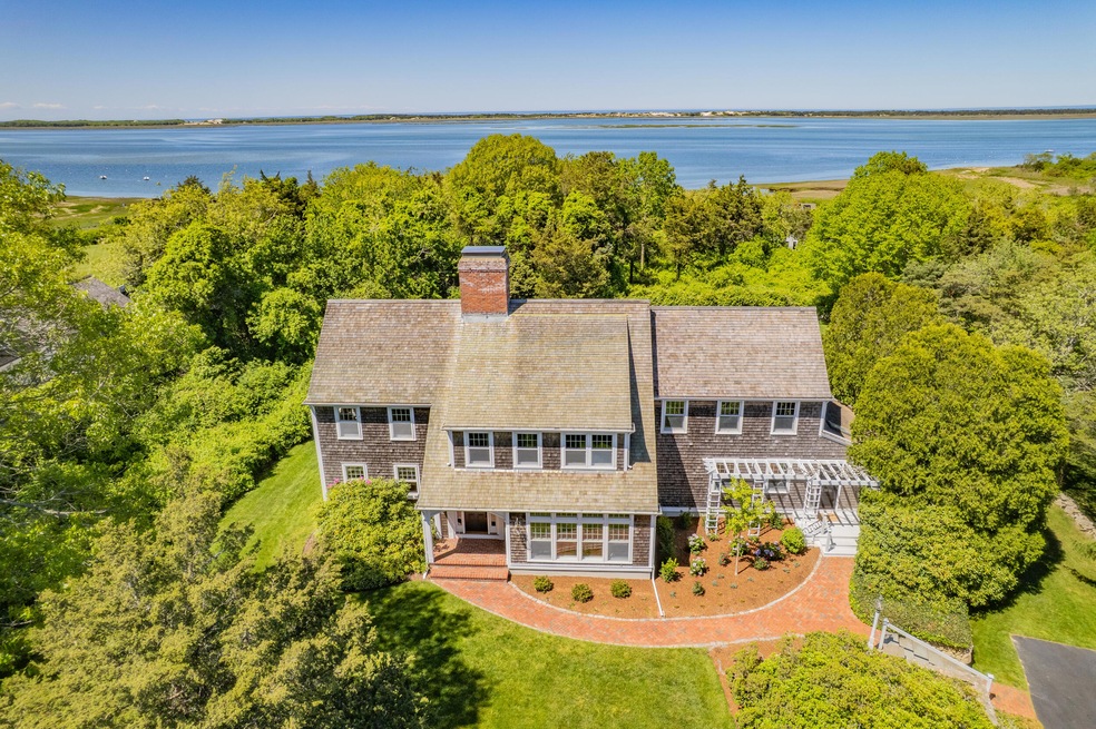
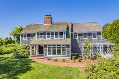
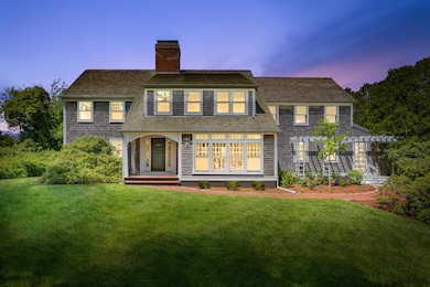
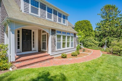
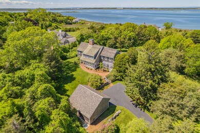
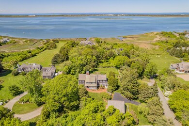

This elegant, shingled style four-bedroom colonial saltbox sits high on a knolloffering delightful views of Barnstable Harbor and Sandy Neck beyond. A rareopportunity on the northside of the Old King's Highway in Barnstable Village, such a property as this seldom becomes available! Deeded beach rights. Clamming, oystering, swimming and fishing are at your doorstep.A home for all seasons, this tastefully designed home has been well maintained and loved by the same family for over 40 years. Its classical design epitomizes the look of years gone by, but has the comfort and decor of present day living. A majestic oak tree bordered by old stone walls frames beautiful vistas of the lush front yard. Mature azaleas, hydrangeas, irises, a fenced vegetable garden and tall cedars adorn the private property. The back deck off the kitchen sliders has lovely views of the water.The front driveway branches to a detached shingled saltbox two car garage, while gorgeous stonewalls and bluestone steps lead to a whimsical pergola covered side entrance shaded by a ginkgo tree, rhododendron bush and a colorful perennial garden. A brick walkway leads to the formal arched portico front entry. The recently designed white kitchen with wide pine floors, custom cabinetry, soapstone countertops, window seat, subway tile backsplash, Shaw's farmer's sink and Wolf range adorn this beautiful working kitchen. Picturesque views from the striking bank of windows reach out over the verdant lawn, gardens and stonewalls to Barnstable Harbor. Light streams through the spectacular sunken sunroom whose restful views invite the reading enthusiast to unwind. Two fireplaces offer warmth for the fall and winter evenings. This beautiful, pristine home is just waiting for the perfect buyer who will fall in love and cherish it for years to come.
Nature trails, historic Sturgis Library, boating, Scudder Landing and Millway beach are close at hand. It's a short walk for morning coffee, the post office, Barnstable Market and restaurants. Enjoy vibrant village life & the privacy and beauty of the Northside from this classical home in a wonderful village neighborhood.
Last Agent to Sell the Property
Bayview Real Estate License #61305 Listed on: 05/31/2025
| Date | Type | Sale Price | Title Company |
|---|---|---|---|
| Quit Claim Deed | $2,175,000 | -- | |
| Quit Claim Deed | $2,175,000 | -- | |
| Quit Claim Deed | -- | None Available | |
| Quit Claim Deed | -- | None Available | |
| Deed | $49,000 | -- |
| Date | Status | Loan Amount | Loan Type |
|---|---|---|---|
| Open | $1,413,750 | New Conventional | |
| Closed | $1,413,750 | New Conventional | |
| Previous Owner | $100,000 | No Value Available |
| Date | Event | Price | List to Sale | Price per Sq Ft |
|---|---|---|---|---|
| 07/17/2025 07/17/25 | Sold | $2,175,000 | +1.2% | $622 / Sq Ft |
| 06/09/2025 06/09/25 | Pending | -- | -- | -- |
| 05/31/2025 05/31/25 | For Sale | $2,150,000 | -- | $615 / Sq Ft |
| Year | Tax Paid | Tax Assessment Tax Assessment Total Assessment is a certain percentage of the fair market value that is determined by local assessors to be the total taxable value of land and additions on the property. | Land | Improvement |
|---|---|---|---|---|
| 2025 | $19,215 | $2,079,500 | $1,148,100 | $931,400 |
| 2024 | $17,200 | $1,963,500 | $1,148,100 | $815,400 |
| 2023 | $15,940 | $1,775,000 | $1,043,900 | $731,100 |
| 2022 | $13,149 | $1,178,200 | $565,500 | $612,700 |
| 2021 | $12,588 | $1,075,000 | $547,600 | $527,400 |
| 2020 | $13,384 | $1,091,700 | $583,600 | $508,100 |
| 2019 | $12,712 | $1,040,300 | $583,600 | $456,700 |
| 2018 | $13,511 | $1,074,000 | $681,000 | $393,000 |
| 2017 | $13,516 | $1,081,300 | $681,000 | $400,300 |
| 2016 | $13,554 | $1,099,300 | $699,000 | $400,300 |
| 2015 | $12,711 | $1,049,600 | $649,700 | $399,900 |
J
Seller's Agent in 2025
Jean Schiffmann
Bayview Real Estate
(508) 776-0868
5 in this area
10 Total Sales
K
Buyer's Agent in 2025
Katie Pazakis
Keller Williams Realty
(917) 974-6831
1 in this area
14 Total Sales
Source: Cape Cod & Islands Association of REALTORS®
MLS Number: 22502655
APN: BARN-000258-000000-000074
Disclaimer: Certain information contained herein is derived from information provided by parties other than Homes.com. All information provided is deemed reliable, but is not guaranteed to be accurate and should be independently verified.
![]() All data relating to real estate for sale on this page comes from the Broker Reciprocity (BR) of the Cape Cod & Islands Multiple Listing Service, Inc. Detailed information about real estate listings held by brokerage firms other than CC&I Assoc. of REALTORS®, Inc. includes the name of the listing company. Neither the listing company nor CC&I Assoc. of REALTORS®, Inc. shall be responsible for any typographical errors, misinformation, misprints and shall be held totally harmless. The Broker providing this data believes it to be correct, but advises interested parties to confirm any item before relying on it in a purchase decision. All properties are subject to prior sale, changes, or withdrawal. Copyright 2026 © Cape Cod & Islands Multiple Listing Service, Inc. All rights reserved.
All data relating to real estate for sale on this page comes from the Broker Reciprocity (BR) of the Cape Cod & Islands Multiple Listing Service, Inc. Detailed information about real estate listings held by brokerage firms other than CC&I Assoc. of REALTORS®, Inc. includes the name of the listing company. Neither the listing company nor CC&I Assoc. of REALTORS®, Inc. shall be responsible for any typographical errors, misinformation, misprints and shall be held totally harmless. The Broker providing this data believes it to be correct, but advises interested parties to confirm any item before relying on it in a purchase decision. All properties are subject to prior sale, changes, or withdrawal. Copyright 2026 © Cape Cod & Islands Multiple Listing Service, Inc. All rights reserved.