Estimated Value: $748,000 - $863,000
5
Beds
2
Baths
1,794
Sq Ft
$443/Sq Ft
Est. Value
About This Home
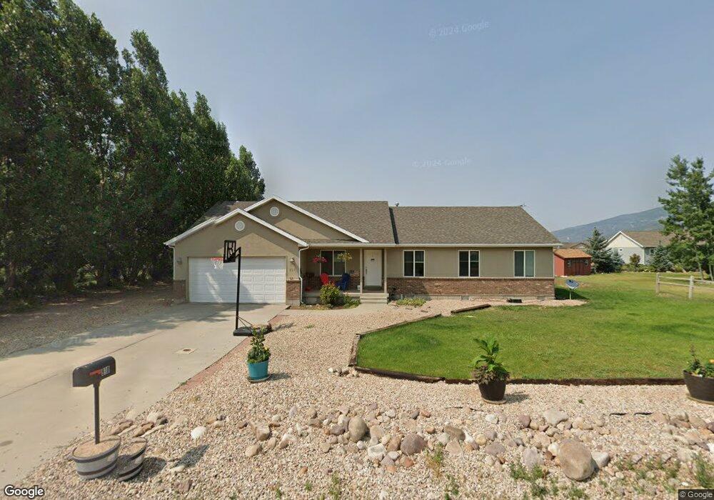
This home is located at 910 Oak Ln, Kamas, UT 84036 and is currently estimated at $795,001, approximately $443 per square foot. 910 Oak Ln is a home located in Summit County with nearby schools including South Summit Elementary School and South Summit High School.
Ownership History
Date
Name
Owned For
Owner Type
Purchase Details
Closed on
May 3, 2017
Sold by
Thornton Lonn R and Thornton Lindsey K
Bought by
Thornton Lonn R and Thornton Lindsey K
Current Estimated Value
Purchase Details
Closed on
Sep 24, 2009
Sold by
Utah Housing Corp
Bought by
Thorton Lonn R and Thorton Lindsey K
Home Financials for this Owner
Home Financials are based on the most recent Mortgage that was taken out on this home.
Original Mortgage
$243,877
Outstanding Balance
$157,135
Interest Rate
5.14%
Mortgage Type
New Conventional
Estimated Equity
$637,866
Purchase Details
Closed on
Mar 22, 2005
Sold by
Herbert Jeff and Herbert Brittiney
Bought by
Herbert Jeffrey R and Herbert Brittiney A
Home Financials for this Owner
Home Financials are based on the most recent Mortgage that was taken out on this home.
Original Mortgage
$140,600
Interest Rate
5.87%
Mortgage Type
Adjustable Rate Mortgage/ARM
Create a Home Valuation Report for This Property
The Home Valuation Report is an in-depth analysis detailing your home's value as well as a comparison with similar homes in the area
Home Values in the Area
Average Home Value in this Area
Purchase History
| Date | Buyer | Sale Price | Title Company |
|---|---|---|---|
| Thornton Lonn R | -- | First American Title Insuran | |
| Thorton Lonn R | -- | -- | |
| Herbert Jeffrey R | -- | Founders Title Co |
Source: Public Records
Mortgage History
| Date | Status | Borrower | Loan Amount |
|---|---|---|---|
| Open | Thorton Lonn R | $243,877 | |
| Previous Owner | Herbert Jeffrey R | $140,600 |
Source: Public Records
Tax History
| Year | Tax Paid | Tax Assessment Tax Assessment Total Assessment is a certain percentage of the fair market value that is determined by local assessors to be the total taxable value of land and additions on the property. | Land | Improvement |
|---|---|---|---|---|
| 2025 | $2,622 | $415,055 | $200,750 | $214,305 |
| 2024 | $2,394 | $401,661 | $175,450 | $226,211 |
| 2023 | $2,394 | $388,461 | $162,250 | $226,211 |
| 2022 | $2,240 | $320,509 | $132,000 | $188,509 |
| 2021 | $2,032 | $226,839 | $73,700 | $153,139 |
| 2020 | $1,854 | $202,531 | $73,700 | $128,831 |
| 2019 | $2,069 | $202,531 | $73,700 | $128,831 |
| 2018 | $1,701 | $172,954 | $66,000 | $106,954 |
| 2017 | $1,560 | $161,954 | $55,000 | $106,954 |
| 2016 | $1,522 | $148,733 | $46,640 | $102,093 |
| 2015 | $1,455 | $139,010 | $0 | $0 |
| 2013 | $1,357 | $120,308 | $0 | $0 |
Source: Public Records
Map
Nearby Homes
- 818 W Summit Haven Cir
- 755 Oak Ln
- 823 W Summit Haven Cir
- 862 W Hilltop Ct
- 1535 Birch Way
- 605 Aspen Rd
- 1373 Sage Way
- 1373 Sage Way Unit 47
- 1333 Sage Way Unit 45
- 1333 Sage Way
- 940 Hart Loop
- 1379 Taylee Ln
- 566 Wild Willow Dr
- 582 Aspen Rd Unit C25
- 1962 Bluff Crest Rd
- 1962 Bluff Crest Rd Unit 4
- 431 Aspen Rd
- 294 W Willow Ct
- 1986 Wren Woods Way
- 1986 Wren Woods Way Unit 13
- 910 Oak Ln Unit A5
- 1286 Birch Way
- 940 Oak Ln
- 940 Oak Ln Unit A4
- 1286 Birch Way
- 1286 Birch Way Unit 102
- 880 Oak Ln
- 905 Oak Ln
- 1326 Birch Way
- 875 Oak Ln
- 1246 Birch Way
- 1246 Birch Way Unit 101
- 1297 Birch Way
- 830 Oak Ln
- 1600 Oak Ln
- 1625 Oak Ln
- 910 Wild Rose Dr
- 910 Wild Rose Dr Unit A-24
- 870 Wild Rose Dr
- 910 Wildrose Dr
Your Personal Tour Guide
Ask me questions while you tour the home.