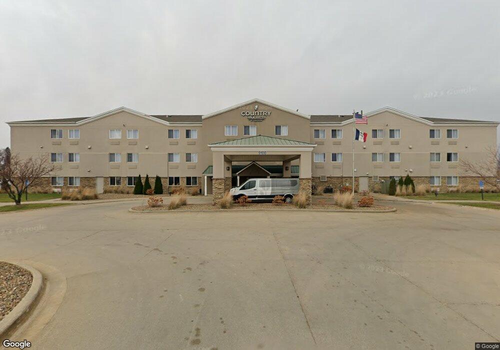
9100 Atlantic Dr SW Cedar Rapids, IA 52404
Estimated Value: $4,287,829
--
Bed
--
Bath
60,000
Sq Ft
$71/Sq Ft
Est. Value
About This Home
This home is located at 9100 Atlantic Dr SW, Cedar Rapids, IA 52404 and is currently estimated at $4,287,829, approximately $71 per square foot. 9100 Atlantic Dr SW is a home located in Linn County with nearby schools including Prairie Crest Elementary School, Prairie Heights Elementary School, and Prairie View Elementary School.
Ownership History
Date
Name
Owned For
Owner Type
Purchase Details
Closed on
Jan 17, 2017
Sold by
Atlantic Avenue Enterprises Llc
Bought by
Cr Airport Hotel Associates Llc
Current Estimated Value
Home Financials for this Owner
Home Financials are based on the most recent Mortgage that was taken out on this home.
Original Mortgage
$4,500,000
Outstanding Balance
$1,091,798
Interest Rate
3.94%
Mortgage Type
Purchase Money Mortgage
Estimated Equity
$3,196,031
Purchase Details
Closed on
Nov 28, 2011
Sold by
Hotel Enterprises Llc
Bought by
Atlantic Avenue Enterprises Llc
Home Financials for this Owner
Home Financials are based on the most recent Mortgage that was taken out on this home.
Original Mortgage
$2,040,000
Interest Rate
4.12%
Mortgage Type
Future Advance Clause Open End Mortgage
Purchase Details
Closed on
Aug 16, 2011
Sold by
Wells Fargo Bank Na
Bought by
Hotel Enterprises Llc
Purchase Details
Closed on
Oct 22, 2002
Sold by
Brazelton Cedar Rapids Group Lc
Bought by
Wells Fargo Bank Na and Brenton Bank
Purchase Details
Closed on
Apr 16, 1998
Sold by
Brazelton Real Estate Inc
Bought by
Brazelton Cedar Rapids Group Lc
Purchase Details
Closed on
Dec 9, 1997
Sold by
Wright Brothers Blvd
Bought by
Brazelton Real Estate Inc
Home Financials for this Owner
Home Financials are based on the most recent Mortgage that was taken out on this home.
Original Mortgage
$300,000
Interest Rate
7.46%
Mortgage Type
Purchase Money Mortgage
Create a Home Valuation Report for This Property
The Home Valuation Report is an in-depth analysis detailing your home's value as well as a comparison with similar homes in the area
Home Values in the Area
Average Home Value in this Area
Purchase History
| Date | Buyer | Sale Price | Title Company |
|---|---|---|---|
| Cr Airport Hotel Associates Llc | -- | None Available | |
| Atlantic Avenue Enterprises Llc | -- | None Available | |
| Hotel Enterprises Llc | -- | None Available | |
| Wells Fargo Bank Na | $1,700,199 | -- | |
| Brazelton Cedar Rapids Group Lc | -- | -- | |
| Brazelton Cedar Rapids Group Lc | -- | -- | |
| Brazelton Real Estate Inc | $324,500 | -- |
Source: Public Records
Mortgage History
| Date | Status | Borrower | Loan Amount |
|---|---|---|---|
| Open | Cr Airport Hotel Associates Llc | $4,500,000 | |
| Previous Owner | Atlantic Avenue Enterprises Llc | $2,040,000 | |
| Previous Owner | Brazelton Real Estate Inc | $300,000 |
Source: Public Records
Tax History Compared to Growth
Tax History
| Year | Tax Paid | Tax Assessment Tax Assessment Total Assessment is a certain percentage of the fair market value that is determined by local assessors to be the total taxable value of land and additions on the property. | Land | Improvement |
|---|---|---|---|---|
| 2025 | $110,164 | $3,308,200 | $430,000 | $2,878,200 |
| 2024 | $99,604 | $3,221,400 | $430,000 | $2,791,400 |
| 2023 | $99,604 | $3,066,300 | $430,000 | $2,636,300 |
| 2022 | $97,800 | $2,789,000 | $430,000 | $2,359,000 |
| 2021 | $98,778 | $5,148,000 | $430,000 | $4,718,000 |
| 2020 | $98,778 | $4,906,700 | $430,000 | $4,476,700 |
| 2019 | $86,442 | $4,629,800 | $430,000 | $4,199,800 |
| 2018 | $86,044 | $2,529,900 | $430,000 | $2,099,900 |
| 2017 | $82,678 | $2,422,600 | $430,000 | $1,992,600 |
| 2016 | $84,813 | $2,422,600 | $430,000 | $1,992,600 |
| 2015 | $87,039 | $2,504,864 | $430,000 | $2,074,864 |
| 2014 | $84,606 | $2,504,864 | $430,000 | $2,074,864 |
| 2013 | $88,556 | $2,504,864 | $430,000 | $2,074,864 |
Source: Public Records
Map
Nearby Homes
- 8905 6th St SW Unit Land Lease
- 0 Lawrence Drive East SW Unit A 2502372
- 0 Lawrence Drive East SW Unit B 2502371
- 0 Lawrence Drive West SW Unit C
- 0 6th St & 76th Ave SW Unit 202505956
- 8515 Aldridge Dr SW
- 160 Bethany Loop SW Unit D
- 160 Bethany Loop SW Unit C
- 160 Bethany Loop SW Unit B
- 160 Bethany Loop SW Unit A
- 110 SW Audrey Way
- 110 SW Audrey Way Unit Lot 11
- 8921 SW Griswold Ln
- 8921 SW Griswold Ln Unit Lot 20
- Hamilton Plan at American Prairie
- Bellhaven Plan at American Prairie
- Roland Plan at American Prairie
- 9305 Snowberry Dr SW
- 8923 SW Brighton Way
- 8923 SW Brighton Way Unit Lot 14
- 755 America Dr SW
- 51 Avenue Dr SW Unit 9
- 635 America Dr SW
- 615 America Dr SW
- 1005 America Dr SW
- 715 America Dr SW
- Lot 23 America Dr SW
- 855 Wright Brothers Blvd SW Unit 2A
- 710 Wright Brothers Blvd SW
- 805 Wright Brothers Blvd SW Unit 4A
- 805 Wright Brothers Blvd SW Unit 2
- 805 Wright Brothers Blvd SW Unit 1
- 915 Wright Brothers Blvd SW
- 9255 Atlantic Dr SW
- 9255 Atlantic Dr SW
- 9255 Atlantic Dr SW
- 640* Wright Brothers Blvd SW
- 640 Wright Brothers Blvd SW
- 1003 Wright Brothers Blvd SW
- 9310 Atlantic Dr SW Unit A