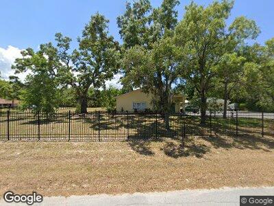
9100 Flint St New Port Richey, FL 34654
Estimated Value: $441,000 - $742,000
--
Bed
2
Baths
4,516
Sq Ft
$134/Sq Ft
Est. Value
About This Home
This home is located at 9100 Flint St, New Port Richey, FL 34654 and is currently estimated at $605,460, approximately $134 per square foot. 9100 Flint St is a home located in Pasco County with nearby schools including Schrader Elementary School, Bayonet Point Middle School, and Fivay High School.
Ownership History
Date
Name
Owned For
Owner Type
Purchase Details
Closed on
Oct 14, 2015
Sold by
Mccormick Shawna M
Bought by
Mccormick Shawna M and Mccormick Carol
Current Estimated Value
Purchase Details
Closed on
Nov 11, 2010
Sold by
Griffin Park Community Club Inc
Bought by
Mccormick Shawna A
Create a Home Valuation Report for This Property
The Home Valuation Report is an in-depth analysis detailing your home's value as well as a comparison with similar homes in the area
Home Values in the Area
Average Home Value in this Area
Purchase History
| Date | Buyer | Sale Price | Title Company |
|---|---|---|---|
| Mccormick Shawna M | $50,000 | Attorney | |
| Mccormick Shawna A | $90,000 | Attorney |
Source: Public Records
Mortgage History
| Date | Status | Borrower | Loan Amount |
|---|---|---|---|
| Open | Mccormick Shawna A | $192,000 | |
| Closed | Mccormick Shawna A | $155,000 | |
| Closed | Mccormick Shawna A | $111,155 | |
| Closed | Mccormick Shawna A | $97,000 |
Source: Public Records
Tax History Compared to Growth
Tax History
| Year | Tax Paid | Tax Assessment Tax Assessment Total Assessment is a certain percentage of the fair market value that is determined by local assessors to be the total taxable value of land and additions on the property. | Land | Improvement |
|---|---|---|---|---|
| 2024 | $4,500 | $294,350 | -- | -- |
| 2023 | $4,334 | $285,780 | $0 | $0 |
| 2022 | $3,894 | $277,460 | $0 | $0 |
| 2021 | $3,823 | $269,380 | $46,818 | $222,562 |
| 2020 | $3,763 | $265,670 | $39,947 | $225,723 |
| 2019 | $3,701 | $259,700 | $0 | $0 |
| 2018 | $3,634 | $254,866 | $0 | $0 |
| 2017 | $3,343 | $260,158 | $0 | $0 |
| 2016 | $3,271 | $228,130 | $0 | $0 |
| 2015 | $2,381 | $171,841 | $0 | $0 |
| 2014 | $2,314 | $190,884 | $35,447 | $155,437 |
Source: Public Records
Map
Nearby Homes
- 11304 Altoona Ave
- 11351 Edison Ave
- 9124 Kosimo St
- 11414 Fox Run
- 9131 Kosimo St
- 11318 Stoneybrook Path
- 9127 Bourbon St
- 11540 Altoona Ave
- 9020 Rye St
- 8737 Beaver Ln
- 11520 Bear Paw Ln
- 9431 Pontiac St
- 10824 Peppertree Ln
- 9150 Kiowa Dr
- 11305 Brown Bear Ln
- 11001 Peppertree Ln
- 11326 Minnieola Dr
- 11010 Salt Tree Dr
- 9305 Kiowa Dr
- 10801 Cedar Breaks Dr Unit 2
- 9100 Flint St
- 9124 Flint St
- 11241 Altoona Ave
- 11240 Altoona Ave
- 11244 Altoona Ave
- 11250 Edison Ave
- 11241 Edison Ave
- 11241 Sage Ave
- 9144 Flint St
- 11251 Edison Ave
- 11251 Sage Ave
- 11310 Edison Ave
- 11230 Little Rd
- 11310 Altoona Ave
- Star Trail
- 11305 Sage Ave
- 11316 Altoona Ave
- 11240 Sage Ave
- 11320 Edison Ave
- 11325 Altoona Ave
