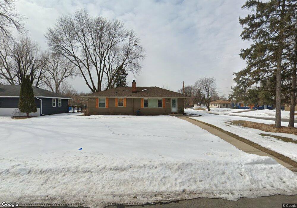
9100 Newton Ave S Minneapolis, MN 55431
West Bloomington NeighborhoodEstimated Value: $362,000 - $401,000
3
Beds
1
Bath
1,056
Sq Ft
$356/Sq Ft
Est. Value
About This Home
This home is located at 9100 Newton Ave S, Minneapolis, MN 55431 and is currently estimated at $376,448, approximately $356 per square foot. 9100 Newton Ave S is a home located in Hennepin County with nearby schools including Washburn Elementary School, Valley View Middle School, and Kennedy Senior High School.
Ownership History
Date
Name
Owned For
Owner Type
Purchase Details
Closed on
May 12, 2000
Sold by
Reichel Philip R and Reichel Nancy
Bought by
Wrase Michael R and Borowski Ania B
Current Estimated Value
Create a Home Valuation Report for This Property
The Home Valuation Report is an in-depth analysis detailing your home's value as well as a comparison with similar homes in the area
Home Values in the Area
Average Home Value in this Area
Purchase History
| Date | Buyer | Sale Price | Title Company |
|---|---|---|---|
| Wrase Michael R | $145,000 | -- |
Source: Public Records
Tax History Compared to Growth
Tax History
| Year | Tax Paid | Tax Assessment Tax Assessment Total Assessment is a certain percentage of the fair market value that is determined by local assessors to be the total taxable value of land and additions on the property. | Land | Improvement |
|---|---|---|---|---|
| 2024 | $4,382 | $349,900 | $134,600 | $215,300 |
| 2023 | $4,009 | $338,100 | $122,800 | $215,300 |
| 2022 | $3,691 | $333,900 | $122,800 | $211,100 |
| 2021 | $3,391 | $296,400 | $119,600 | $176,800 |
| 2020 | $3,355 | $276,900 | $116,200 | $160,700 |
| 2019 | $3,058 | $267,400 | $116,200 | $151,200 |
| 2018 | $2,944 | $242,100 | $116,000 | $126,100 |
| 2017 | $2,705 | $213,900 | $101,600 | $112,300 |
| 2016 | $2,725 | $205,500 | $96,400 | $109,100 |
| 2015 | $2,625 | $192,400 | $93,500 | $98,900 |
| 2014 | -- | $178,200 | $90,600 | $87,600 |
Source: Public Records
Map
Nearby Homes
- 9149 Queen Ave S
- 2101 W 89th St
- 8831 Queen Ave S
- 8836 James Ave S
- 2300 W 95th St
- 8545 Penn Ave S
- 1706 W 86th St
- 8525 Penn Ave S
- 9609 Vincent Ave S
- 8706 Aldrich Ave S
- 9824 Fremont Ave S
- 8212 Fremont Ave S Unit D
- 8264 York Ave S
- 9522 Pleasant Ave S
- 9020 Blaisdell Ave S
- 8114 Emerson Ave S
- 8117 Xerxes Cir
- 8256 Beard Rd
- 3801 W 98th St Unit 402
- 2113 Village Terrace
- 9108 Newton Ave S
- 9101 Oliver Ave S
- 2108 W 91st St
- 9109 Oliver Ave S
- 9116 Newton Ave S
- 2100 W 91st St
- 2116 W 91st St
- 9101 Newton Ave S
- 9109 Newton Ave S
- 9117 Oliver Ave S
- 2016 W 91st St
- 2124 W 91st St
- 9124 Newton Ave S
- 9117 Newton Ave S
- 2132 W 91st St
- 2008 W 91st St
- 9125 Oliver Ave S
- 9125 Newton Ave S
- 9132 Newton Ave S
- 9108 Morgan Ave S