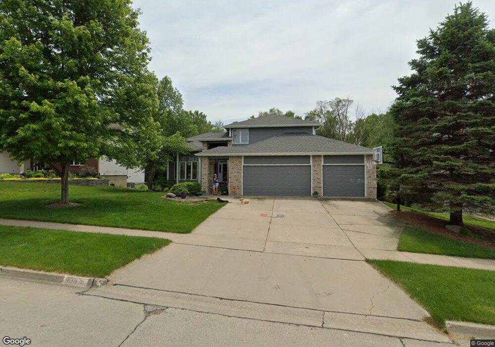
9110 Hammontree Dr Urbandale, IA 50322
Estimated Value: $446,000 - $630,000
4
Beds
3
Baths
2,984
Sq Ft
$174/Sq Ft
Est. Value
About This Home
This home is located at 9110 Hammontree Dr, Urbandale, IA 50322 and is currently estimated at $518,016, approximately $173 per square foot. 9110 Hammontree Dr is a home located in Polk County with nearby schools including Urbandale Middle School, Urbandale High School, and St Pius X School.
Ownership History
Date
Name
Owned For
Owner Type
Purchase Details
Closed on
May 17, 2001
Sold by
Levy David J and Levy Margaret J
Bought by
Kusy William F and Kusy Cynthia J
Current Estimated Value
Home Financials for this Owner
Home Financials are based on the most recent Mortgage that was taken out on this home.
Original Mortgage
$244,000
Outstanding Balance
$91,379
Interest Rate
7.07%
Estimated Equity
$426,637
Create a Home Valuation Report for This Property
The Home Valuation Report is an in-depth analysis detailing your home's value as well as a comparison with similar homes in the area
Home Values in the Area
Average Home Value in this Area
Purchase History
| Date | Buyer | Sale Price | Title Company |
|---|---|---|---|
| Kusy William F | $304,500 | -- |
Source: Public Records
Mortgage History
| Date | Status | Borrower | Loan Amount |
|---|---|---|---|
| Open | Kusy William F | $244,000 |
Source: Public Records
Tax History Compared to Growth
Tax History
| Year | Tax Paid | Tax Assessment Tax Assessment Total Assessment is a certain percentage of the fair market value that is determined by local assessors to be the total taxable value of land and additions on the property. | Land | Improvement |
|---|---|---|---|---|
| 2025 | $7,786 | $497,800 | $89,300 | $408,500 |
| 2024 | $7,786 | $440,300 | $77,800 | $362,500 |
| 2023 | $7,872 | $440,300 | $77,800 | $362,500 |
| 2022 | $7,780 | $375,800 | $68,900 | $306,900 |
| 2021 | $7,652 | $375,800 | $68,900 | $306,900 |
| 2020 | $7,520 | $351,100 | $64,400 | $286,700 |
| 2019 | $7,292 | $351,100 | $64,400 | $286,700 |
| 2018 | $7,022 | $325,600 | $57,200 | $268,400 |
| 2017 | $6,590 | $325,600 | $57,200 | $268,400 |
| 2016 | $6,424 | $300,800 | $51,700 | $249,100 |
| 2015 | $6,424 | $300,800 | $51,700 | $249,100 |
| 2014 | $6,090 | $294,500 | $49,700 | $244,800 |
Source: Public Records
Map
Nearby Homes
- 9107 Tanglewood Dr
- 4460 90th St
- 4221 90th St
- 4473 89th St
- 8914 Valdez Dr
- 4529 91st St
- 4480 87th St Unit 10
- 8626 Alpine Dr Unit D
- 8641 Alpine Dr Unit E
- 3957 92nd Dr
- 4748 Hillsdale Dr
- 4708 89th St
- Danbury Plan at Oakwood Haven
- Carson Plan at Oakwood Haven
- Gilmore Plan at Oakwood Haven
- Emerson Plan at Oakwood Haven
- Brighton Plan at Oakwood Haven
- Cambridge Plan at Oakwood Haven
- Aurora Plan at Oakwood Haven
- Fairfield Plan at Oakwood Haven
- 9104 Hammontree Dr
- 9116 Hammontree Dr
- 9100 Hammontree Dr
- 9120 Hammontree Dr
- 9109 Hammontree Dr
- 9115 Hammontree Dr
- 9103 Hammontree Dr
- 9121 Hammontree Dr
- 9028 Hammontree Dr
- 9029 Hammontree Dr
- 9124 Hammontree Dr
- 9125 Hammontree Dr
- 9118 Tanglewood Dr
- 9114 Tanglewood Dr
- 9024 Hammontree Dr
- 9025 Hammontree Dr
- 9122 Tanglewood Dr
- 9112 Tanglewood Dr
- 4300 92nd St
- 4305 92nd St