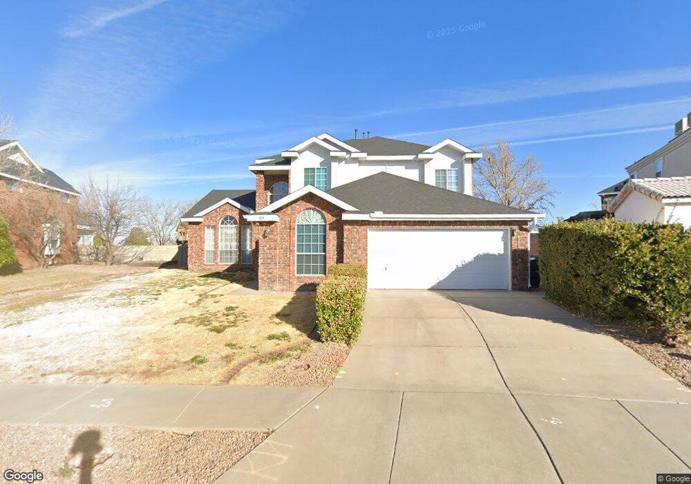
9119 MacAllan Rd NE Albuquerque, NM 87109
Heritage East NeighborhoodEstimated Value: $608,000 - $659,000
4
Beds
4
Baths
2,628
Sq Ft
$239/Sq Ft
Est. Value
About This Home
This home is located at 9119 MacAllan Rd NE, Albuquerque, NM 87109 and is currently estimated at $627,329, approximately $238 per square foot. 9119 MacAllan Rd NE is a home located in Bernalillo County with nearby schools including Hubert H. Humphrey Elementary School, Eisenhower Middle School, and La Cueva High School.
Ownership History
Date
Name
Owned For
Owner Type
Purchase Details
Closed on
Mar 11, 2004
Sold by
Grant Myron L and Grant Linda Lea
Bought by
Grant Myron L and Grant Linda L
Current Estimated Value
Home Financials for this Owner
Home Financials are based on the most recent Mortgage that was taken out on this home.
Original Mortgage
$125,650
Interest Rate
5.71%
Mortgage Type
New Conventional
Create a Home Valuation Report for This Property
The Home Valuation Report is an in-depth analysis detailing your home's value as well as a comparison with similar homes in the area
Home Values in the Area
Average Home Value in this Area
Purchase History
| Date | Buyer | Sale Price | Title Company |
|---|---|---|---|
| Grant Myron L | -- | Fidelity Natl Title Ins Co |
Source: Public Records
Mortgage History
| Date | Status | Borrower | Loan Amount |
|---|---|---|---|
| Closed | Grant Myron L | $125,650 |
Source: Public Records
Tax History Compared to Growth
Tax History
| Year | Tax Paid | Tax Assessment Tax Assessment Total Assessment is a certain percentage of the fair market value that is determined by local assessors to be the total taxable value of land and additions on the property. | Land | Improvement |
|---|---|---|---|---|
| 2025 | $5,652 | $140,037 | $38,344 | $101,693 |
| 2024 | $5,652 | $135,958 | $37,227 | $98,731 |
| 2023 | $5,555 | $131,999 | $36,143 | $95,856 |
| 2022 | $5,366 | $128,154 | $35,090 | $93,064 |
| 2021 | $5,183 | $124,423 | $34,069 | $90,354 |
| 2020 | $5,096 | $120,798 | $33,076 | $87,722 |
| 2019 | $4,944 | $117,280 | $32,113 | $85,167 |
| 2018 | $4,765 | $117,280 | $32,113 | $85,167 |
| 2017 | $4,616 | $113,865 | $31,178 | $82,687 |
| 2016 | $4,481 | $107,329 | $29,388 | $77,941 |
| 2015 | $104,203 | $104,203 | $28,532 | $75,671 |
| 2014 | $4,211 | $101,169 | $27,702 | $73,467 |
| 2013 | -- | $98,222 | $26,895 | $71,327 |
Source: Public Records
Map
Nearby Homes
- 0 Palomas Ave NE Unit 1090779
- 0 Palomas Ave NE Unit 1090778
- 8927 Desert Fox Way NE
- 8300 Visalia Way NE
- 8718 Liberty Dr NE
- 8212 Grape View Ct NE
- 9612 Rosas Ave NE
- 8423 Petaluma Dr NE
- 8719 Desert Fox Way NE
- 8819 Greenarbor Rd NE
- 9505 Giddings Ave NE
- 11250 Corona Ave NE
- 9727 Blue Dove NE
- 9719 Blue Dove Place NE
- 9705 Blue Dove Place NE
- 9727 Blue Dove Place NE
- 11620 Wilshire Ave NE
- 8504 Sonoma Valley Dr NE
- 9834 Desert Lark Place NE Unit 33
- 7416 Don Tomas Ln NE
- 9123 MacAllan Rd NE
- 9115 MacAllan Rd NE
- 9127 MacAllan Rd NE
- 9116 MacAllan Rd NE
- 9109 MacAllan Rd NE
- 9108 MacAllan Rd NE
- 9124 MacAllan Rd NE
- 9131 MacAllan Rd NE
- 9105 MacAllan Rd NE
- 9132 MacAllan Rd NE
- 9201 MacAllan Rd NE
- 9100 MacAllan Rd NE
- 9109 Palomas Ave NE
- 9135 MacAllan Rd NE
- 9115 Palomas Ave NE
- 9200 MacAllan Rd NE
- 9101 MacAllan Rd NE
- 9119 Palomas Ave NE
- 9205 MacAllan Rd NE
- 9204 MacAllan Rd NE