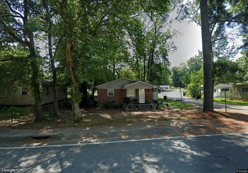
913 W Franklin St Anderson, SC 29624
Estimated Value: $52,741 - $150,000
--
Bed
--
Bath
801
Sq Ft
$115/Sq Ft
Est. Value
About This Home
This home is located at 913 W Franklin St, Anderson, SC 29624 and is currently estimated at $92,185, approximately $115 per square foot. 913 W Franklin St is a home located in Anderson County with nearby schools including Varennes Elementary School, Robert Anderson Middle School, and Westside High School.
Ownership History
Date
Name
Owned For
Owner Type
Purchase Details
Closed on
Feb 24, 2023
Sold by
Hall Cubby M
Bought by
M2n Llc
Current Estimated Value
Home Financials for this Owner
Home Financials are based on the most recent Mortgage that was taken out on this home.
Original Mortgage
$330,000
Interest Rate
6.13%
Mortgage Type
New Conventional
Purchase Details
Closed on
Apr 15, 2005
Sold by
Mattison Harold
Bought by
Hall Cubby Mclester
Create a Home Valuation Report for This Property
The Home Valuation Report is an in-depth analysis detailing your home's value as well as a comparison with similar homes in the area
Home Values in the Area
Average Home Value in this Area
Purchase History
| Date | Buyer | Sale Price | Title Company |
|---|---|---|---|
| M2n Llc | $290,000 | South Carolina Title | |
| Hall Cubby Mclester | $10,000 | -- |
Source: Public Records
Mortgage History
| Date | Status | Borrower | Loan Amount |
|---|---|---|---|
| Closed | M2n Llc | $330,000 |
Source: Public Records
Tax History Compared to Growth
Tax History
| Year | Tax Paid | Tax Assessment Tax Assessment Total Assessment is a certain percentage of the fair market value that is determined by local assessors to be the total taxable value of land and additions on the property. | Land | Improvement |
|---|---|---|---|---|
| 2024 | $996 | $2,130 | $300 | $1,830 |
| 2023 | $996 | $1,810 | $300 | $1,510 |
| 2022 | $778 | $1,810 | $300 | $1,510 |
| 2021 | $765 | $1,720 | $210 | $1,510 |
| 2020 | $756 | $1,720 | $210 | $1,510 |
| 2019 | $756 | $1,720 | $210 | $1,510 |
| 2018 | $749 | $1,720 | $210 | $1,510 |
| 2017 | -- | $1,720 | $210 | $1,510 |
| 2016 | $654 | $1,740 | $150 | $1,590 |
| 2015 | $656 | $1,740 | $150 | $1,590 |
| 2014 | $645 | $1,740 | $150 | $1,590 |
Source: Public Records
Map
Nearby Homes
- 720 722 Gary St
- 00 Ila St
- 00 W Franklin St
- 0 W Franklin St
- 404 Montague St
- 1105 W Franklin St
- 701 Delia St
- 701 Delia St Unit B
- 701 Delia St Unit A
- 0 W Reed St
- 428 W Reed St Unit A&B
- 719 Dora Dr
- 424 W Reed St Unit A&B
- 426 W Reed St Unit A&B
- 403 Rose Hill
- 422 W Reed St Unit A&B
- 1103 Scott Dr
- 902 W Market St
- 111 Maxwell Ave
- Lot 1 & 2 W Market St