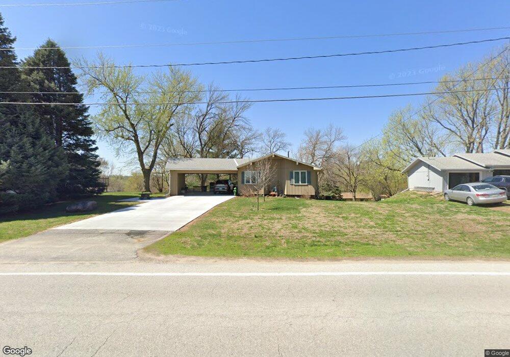
914 N Locust St Glenwood, IA 51534
Estimated Value: $236,619 - $334,000
2
Beds
2
Baths
1,672
Sq Ft
$163/Sq Ft
Est. Value
About This Home
This home is located at 914 N Locust St, Glenwood, IA 51534 and is currently estimated at $272,155, approximately $162 per square foot. 914 N Locust St is a home located in Mills County with nearby schools including Northeast Elementary School, West Elementary School, and Glenwood Middle School.
Ownership History
Date
Name
Owned For
Owner Type
Purchase Details
Closed on
Aug 10, 2018
Sold by
Delavan Marshall W
Bought by
Delavan Marshall W and Delavan Tracy L
Current Estimated Value
Home Financials for this Owner
Home Financials are based on the most recent Mortgage that was taken out on this home.
Original Mortgage
$120,000
Outstanding Balance
$103,998
Interest Rate
4.5%
Mortgage Type
New Conventional
Estimated Equity
$168,157
Create a Home Valuation Report for This Property
The Home Valuation Report is an in-depth analysis detailing your home's value as well as a comparison with similar homes in the area
Home Values in the Area
Average Home Value in this Area
Purchase History
| Date | Buyer | Sale Price | Title Company |
|---|---|---|---|
| Delavan Marshall W | -- | -- |
Source: Public Records
Mortgage History
| Date | Status | Borrower | Loan Amount |
|---|---|---|---|
| Open | Delavan Marshall W | $120,000 |
Source: Public Records
Tax History Compared to Growth
Tax History
| Year | Tax Paid | Tax Assessment Tax Assessment Total Assessment is a certain percentage of the fair market value that is determined by local assessors to be the total taxable value of land and additions on the property. | Land | Improvement |
|---|---|---|---|---|
| 2025 | $3,532 | $236,341 | $42,323 | $194,018 |
| 2024 | $3,532 | $212,514 | $42,323 | $170,191 |
| 2023 | $3,666 | $208,641 | $23,513 | $185,128 |
| 2022 | $3,574 | $173,582 | $23,513 | $150,069 |
| 2021 | $3,280 | $173,582 | $23,513 | $150,069 |
| 2020 | $3,280 | $150,494 | $23,513 | $126,981 |
| 2019 | $2,998 | $138,951 | $0 | $0 |
| 2018 | $2,934 | $138,951 | $0 | $0 |
| 2017 | $2,934 | $133,931 | $0 | $0 |
| 2016 | $2,492 | $133,931 | $0 | $0 |
| 2015 | $2,492 | $133,931 | $0 | $0 |
| 2014 | $2,480 | $133,931 | $0 | $0 |
Source: Public Records
Map
Nearby Homes
- 910 N Locust St
- 123 Hillcrest Ave
- 1103 N Locust St
- 12 Pinehurst Cir
- 103 W Florence Ave
- 608 N Locust St
- 102 Shamrock Cir
- 605 N Locust St
- 314 10th St
- 407 N Myrtle St
- 1113 Arbor Ln
- 1115 Arbor Ln
- 316 Louise Ave
- 311 N Grove St
- 310 N Hazel St
- 410 N Vine St
- 200 10th St
- 57162 225th St
- 206 N Linn St
- 111 N Chestnut St
- 912 N Locust St
- 916 N Locust St
- 141 Glenbrook Dr
- 139 Glenbrook Dr
- 143 Glenbrook Dr
- 918 N Locust St
- 1007 N Locust St
- 137 Glenbrook Dr
- 145 Glenbrook Dr
- 1011 N Locust St
- 135 Glenbrook Dr
- 1001 N Locust St
- 138 Glenbrook Dr
- 133 Glenbrook Dr
- 136 Glenbrook Dr
- 206 Woodlawn Ave
- 140 Glenbrook Dr
- 204 Woodlawn Ave
- 202 Woodlawn Ave
- 306 Harolds Dr