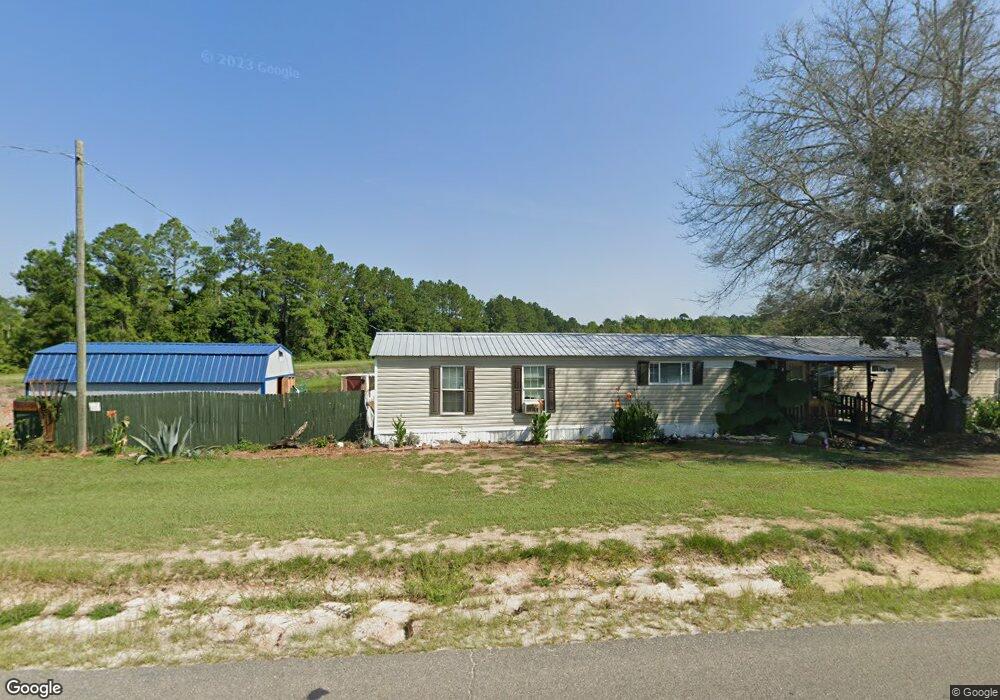
914 Sandy Bottom Rd Blackshear, GA 31516
Estimated Value: $38,996 - $135,000
3
Beds
2
Baths
924
Sq Ft
$111/Sq Ft
Est. Value
About This Home
This home is located at 914 Sandy Bottom Rd, Blackshear, GA 31516 and is currently estimated at $102,749, approximately $111 per square foot. 914 Sandy Bottom Rd is a home with nearby schools including Pierce County High School.
Ownership History
Date
Name
Owned For
Owner Type
Purchase Details
Closed on
Jul 21, 2021
Sold by
Denton Joseph Eldridge
Bought by
May Debbie Nim
Current Estimated Value
Home Financials for this Owner
Home Financials are based on the most recent Mortgage that was taken out on this home.
Original Mortgage
$11,000
Interest Rate
3%
Mortgage Type
New Conventional
Purchase Details
Closed on
Sep 29, 2020
Sold by
Denton M Ashley
Bought by
Denton Joseph E and Ashley Denton M
Purchase Details
Closed on
Mar 7, 2003
Sold by
Denton William N and Denton Ashley M
Bought by
Taft David
Purchase Details
Closed on
Dec 10, 2001
Sold by
Peoples Bank
Bought by
Denton William N and Denton Ashley M
Purchase Details
Closed on
Nov 6, 2001
Sold by
Minchew Mike
Bought by
Peoples Bank
Purchase Details
Closed on
Jul 28, 1999
Sold by
Menchew Mike
Bought by
First Family Financi
Create a Home Valuation Report for This Property
The Home Valuation Report is an in-depth analysis detailing your home's value as well as a comparison with similar homes in the area
Purchase History
| Date | Buyer | Sale Price | Title Company |
|---|---|---|---|
| May Debbie Nim | $12,000 | -- | |
| Denton Joseph E | $11,948 | -- | |
| Taft David | $19,000 | -- | |
| Denton William N | $5,400 | -- | |
| Peoples Bank | -- | -- | |
| First Family Financi | $1,500 | -- |
Source: Public Records
Mortgage History
| Date | Status | Borrower | Loan Amount |
|---|---|---|---|
| Closed | May Debbie Nim | $11,000 |
Source: Public Records
Tax History
| Year | Tax Paid | Tax Assessment Tax Assessment Total Assessment is a certain percentage of the fair market value that is determined by local assessors to be the total taxable value of land and additions on the property. | Land | Improvement |
|---|---|---|---|---|
| 2025 | $135 | $5,762 | $4,762 | $1,000 |
| 2024 | $135 | $5,762 | $4,762 | $1,000 |
| 2023 | $135 | $5,594 | $0 | $5,594 |
| 2022 | $115 | $4,266 | $3,466 | $800 |
| 2021 | $113 | $4,266 | $3,466 | $800 |
| 2020 | $115 | $4,336 | $0 | $4,336 |
| 2019 | $116 | $4,405 | $0 | $4,405 |
| 2018 | $231 | $4,454 | $0 | $4,454 |
| 2017 | $229 | $8,335 | $3,301 | $5,034 |
| 2016 | $227 | $8,335 | $3,301 | $5,034 |
| 2015 | $186 | $8,335 | $3,301 | $5,034 |
| 2014 | $186 | $8,311 | $3,301 | $5,010 |
| 2013 | $186 | $8,310 | $3,301 | $5,009 |
Source: Public Records
Map
Nearby Homes
- 0 Jamestown Rd Unit 10681006
- 0 Jamestown Rd Unit 25595234
- 0 Jamestown Rd Unit 25595235
- 0 Jamestown Rd Unit 1659420
- 0 Jamestown Rd Unit 26418847
- 0 Jamestown Rd Unit 25323571
- 5560 Tara Rd
- 1335 Clifford Loop
- 5710 Wooddell Ridge Rd
- 5625 Wooddell Dr
- Lot 51 Ridge Loop Rd
- 4618 Old Waltertown Rd
- 1320 Whitney Lake Rd
- 5802 River Trail
- 5768 Holly Dr
- 5856 AND 5860 Ridge Rd
- 4190 Church Street Extension
- 4167 Jamestown Rd
- 5641 Fleetwood Ln
- Lot 16 Wiregrass Ln Unit 16
- 0 Jamestown Rd Unit 7449080
- 0 Jamestown Rd Unit 7449057
- 0 Jamestown Rd Unit 24766534
- 0 Jamestown Rd Unit 1655675
- 0 Jamestown Rd Unit 10575588
- 0 Jamestown Rd Unit 24141146
- 0 Jamestown Rd Unit 24069828
- 0 Jamestown Rd Unit 10297084
- 0 Jamestown Rd Unit 10297255
- 0 Jamestown Rd Unit 1650174
- 0 Jamestown Rd Unit 10411853
- 0 Jamestown Rd Unit 34697
- 0 Jamestown Rd Unit 10277086
- 0 Jamestown Rd Unit 1645854
- 0 Jamestown Rd Unit 34037
- 0 Jamestown Rd Unit 10196223
- 0 Jamestown Rd Unit 1641710
- 0 Jamestown Rd Unit 1640136
- 0 Jamestown Rd Unit 10162732
- 0 Jamestown Rd Unit 28427
Your Personal Tour Guide
Ask me questions while you tour the home.