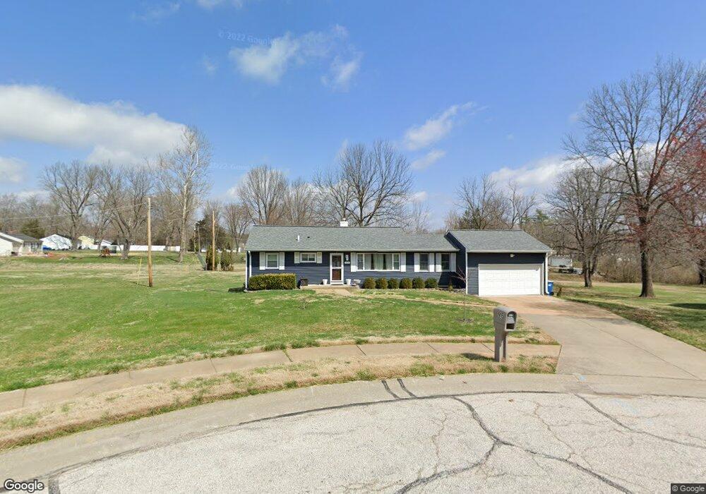
915 Kent Ct Ballwin, MO 63011
Estimated Value: $250,000 - $281,000
3
Beds
1
Bath
1,079
Sq Ft
$243/Sq Ft
Est. Value
About This Home
This home is located at 915 Kent Ct, Ballwin, MO 63011 and is currently estimated at $261,970, approximately $242 per square foot. 915 Kent Ct is a home located in St. Louis County with nearby schools including Westridge Elementary School, Crestview Middle School, and Marquette Sr. High School.
Ownership History
Date
Name
Owned For
Owner Type
Purchase Details
Closed on
Sep 4, 2009
Sold by
Mowczko Joe and Mowczko Jozef D
Bought by
Mowczko Jozef D
Current Estimated Value
Home Financials for this Owner
Home Financials are based on the most recent Mortgage that was taken out on this home.
Original Mortgage
$145,319
Outstanding Balance
$95,375
Interest Rate
5.26%
Mortgage Type
FHA
Estimated Equity
$166,595
Create a Home Valuation Report for This Property
The Home Valuation Report is an in-depth analysis detailing your home's value as well as a comparison with similar homes in the area
Home Values in the Area
Average Home Value in this Area
Purchase History
| Date | Buyer | Sale Price | Title Company |
|---|---|---|---|
| Mowczko Jozef D | -- | Integrity Land Title Co Inc | |
| Mowczko Joe | $148,000 | Integrity Land Title Co Inc |
Source: Public Records
Mortgage History
| Date | Status | Borrower | Loan Amount |
|---|---|---|---|
| Open | Mowczko Joe | $145,319 |
Source: Public Records
Tax History
| Year | Tax Paid | Tax Assessment Tax Assessment Total Assessment is a certain percentage of the fair market value that is determined by local assessors to be the total taxable value of land and additions on the property. | Land | Improvement |
|---|---|---|---|---|
| 2025 | $2,807 | $45,710 | $32,660 | $13,050 |
| 2024 | $2,807 | $39,960 | $23,330 | $16,630 |
| 2023 | $2,804 | $39,960 | $23,330 | $16,630 |
| 2022 | $2,568 | $33,950 | $25,670 | $8,280 |
| 2021 | $2,549 | $33,950 | $25,670 | $8,280 |
| 2020 | $2,206 | $27,970 | $18,260 | $9,710 |
| 2019 | $2,215 | $27,970 | $18,260 | $9,710 |
| 2018 | $2,125 | $25,290 | $14,440 | $10,850 |
| 2016 | $2,071 | $24,280 | $10,200 | $14,080 |
Source: Public Records
Map
Nearby Homes
- 222 Dale Ct
- 807 Portsdown Rd Unit 33D
- 128 Shadalane Walk Unit A
- 845 Wendevy Ct Unit 12B
- 140 Burtonwood Dr
- 842 Wendevy Ct
- 832 Wendevy Ct Unit 8B
- 839 Lilybud Ct Unit 5A
- 815 Wendevy Ct Unit 16B
- 835 Lilybud Ct Unit 5C
- 131 Romine Cir
- 313 Providence Rd
- 239 E Skyline Dr
- 208 Corral Trail
- 127 Ivy Ct
- 609 Log Hill Ct
- 53 Log Hill Ln
- 1019 Claytonbrook Dr Unit 1019
- 502 Trevi Ln
- 538 Triton Way Dr
- 913 Kent Ct
- 218 Dale Ct
- 917 Kent Ct
- 212 Highview Dr
- 217 Dale Ct
- 214 Highview Dr
- 914 Kent Ct
- 916 Kent Ct
- 220 Dale Ct
- 0 Avondale Model at Meadowbrook
- 0tbblt Avondale Model at Meadowbrook
- 216 Highview Dr
- 215 Hillsdale Dr
- 211 Highview Dr
- 213 Highview Dr
- 213 Hillsdale Dr
- 219 Dale Ct
- 206 Highview Dr
- 226 Highview Dr
- 209 Highview Dr
Your Personal Tour Guide
Ask me questions while you tour the home.