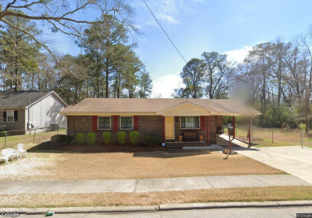
916 Borton St Lagrange, GA 30241
Estimated Value: $119,000 - $132,000
3
Beds
2
Baths
1,134
Sq Ft
$111/Sq Ft
Est. Value
About This Home
This home is located at 916 Borton St, Lagrange, GA 30241 and is currently estimated at $125,398, approximately $110 per square foot. 916 Borton St is a home located in Troup County with nearby schools including Hollis Hand Elementary School, Franklin Forest Elementary School, and Ethel W. Kight Elementary School.
Ownership History
Date
Name
Owned For
Owner Type
Purchase Details
Closed on
Nov 30, 2023
Sold by
Allen Charlie Henry
Bought by
Allen Charles Ramon and Allen Derrick
Current Estimated Value
Purchase Details
Closed on
Aug 10, 1999
Sold by
Love & Affection To 1 Another
Bought by
Allen Charles H
Purchase Details
Closed on
May 11, 1990
Sold by
Charles H Allen
Bought by
Love & Affection To 1 Another
Purchase Details
Closed on
Jan 1, 1973
Sold by
Stiggers?
Bought by
Charles H Allen
Purchase Details
Closed on
Oct 29, 1971
Bought by
Stiggers?
Purchase Details
Closed on
Jan 1, 1971
Purchase Details
Closed on
Jan 1, 1969
Sold by
Laura Hardy
Purchase Details
Closed on
Jan 1, 1949
Bought by
Laura Hardy
Create a Home Valuation Report for This Property
The Home Valuation Report is an in-depth analysis detailing your home's value as well as a comparison with similar homes in the area
Home Values in the Area
Average Home Value in this Area
Purchase History
| Date | Buyer | Sale Price | Title Company |
|---|---|---|---|
| Allen Charles Ramon | -- | -- | |
| Allen Charles Ramon | -- | -- | |
| Allen Charles H | -- | -- | |
| Love & Affection To 1 Another | -- | -- | |
| Charles H Allen | $18,100 | -- | |
| Stiggers? | -- | -- | |
| -- | -- | -- | |
| -- | -- | -- | |
| Laura Hardy | -- | -- |
Source: Public Records
Tax History Compared to Growth
Tax History
| Year | Tax Paid | Tax Assessment Tax Assessment Total Assessment is a certain percentage of the fair market value that is determined by local assessors to be the total taxable value of land and additions on the property. | Land | Improvement |
|---|---|---|---|---|
| 2024 | $1,219 | $44,680 | $3,720 | $40,960 |
| 2023 | $221 | $28,000 | $3,720 | $24,280 |
| 2022 | $680 | $26,360 | $3,720 | $22,640 |
| 2021 | $559 | $20,528 | $2,520 | $18,008 |
| 2020 | $559 | $20,528 | $2,520 | $18,008 |
| 2019 | $510 | $18,896 | $2,552 | $16,344 |
| 2018 | $510 | $18,896 | $2,552 | $16,344 |
| 2017 | $510 | $18,896 | $2,552 | $16,344 |
| 2016 | $494 | $18,366 | $2,552 | $15,814 |
| 2015 | $495 | $18,366 | $2,552 | $15,814 |
| 2014 | $471 | $17,534 | $2,552 | $14,982 |
| 2013 | -- | $20,459 | $2,552 | $17,907 |
Source: Public Records
Map
Nearby Homes
- LOT 4 Borton St
- LOT 3 Borton St
- LOT 5 Borton St
- LOT 6 Borton St
- 1017 Mason St
- 0 Kelley St Unit 10550311
- 957 Kelley St
- 626 Smoot St
- 510 Smoot St
- 0 Brown St Unit 10550761
- 0 Brown St Unit 10550754
- 203 Revis St
- 205 Revis St
- 0 Burr St
- 306 Burr St
- 200 Mccall St
- 117 Belk St
- 0 Locust St
- 105 Dix St
- LOT 58 Belk St