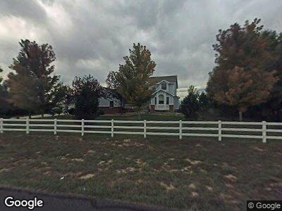
917 Palomino Way Windsor, CO 80550
Estimated Value: $1,024,685 - $1,099,000
5
Beds
3
Baths
3,600
Sq Ft
$296/Sq Ft
Est. Value
About This Home
This home is located at 917 Palomino Way, Windsor, CO 80550 and is currently estimated at $1,066,421, approximately $296 per square foot. 917 Palomino Way is a home located in Weld County with nearby schools including Windsor Middle School, Windsor High School, and Windsor Charter Academy Elementary School.
Ownership History
Date
Name
Owned For
Owner Type
Purchase Details
Closed on
Sep 28, 2016
Bought by
Schneider-Oakley Deidre
Current Estimated Value
Home Financials for this Owner
Home Financials are based on the most recent Mortgage that was taken out on this home.
Original Mortgage
$489,200
Outstanding Balance
$397,655
Interest Rate
3.48%
Estimated Equity
$668,766
Purchase Details
Closed on
May 17, 2010
Sold by
Hughes Kevin T and Hughes Catherine A
Bought by
Poudre Investment Holdings Llc
Purchase Details
Closed on
Mar 17, 2010
Sold by
Poudre Investment Holdings Llc
Bought by
Mile Hi Investments Llc
Purchase Details
Closed on
Sep 24, 2004
Sold by
Poudre Investment Holdings Llc
Bought by
Burns David C
Home Financials for this Owner
Home Financials are based on the most recent Mortgage that was taken out on this home.
Original Mortgage
$426,893
Interest Rate
4.48%
Mortgage Type
FHA
Purchase Details
Closed on
Dec 10, 1997
Sold by
Cornerstone Development & Construction I
Bought by
Hughes Kevin T and Hughes Catherine A
Home Financials for this Owner
Home Financials are based on the most recent Mortgage that was taken out on this home.
Original Mortgage
$231,900
Interest Rate
7%
Purchase Details
Closed on
Sep 12, 1996
Sold by
Cornerstone Development & Construction
Bought by
Cornerstone Development & Const Inc
Purchase Details
Closed on
Dec 19, 1995
Sold by
Hillside Commercial Group Inc
Bought by
Cornerstone Development & Cons
Purchase Details
Closed on
Jun 11, 1994
Bought by
Hillside Commercial Group Inc
Create a Home Valuation Report for This Property
The Home Valuation Report is an in-depth analysis detailing your home's value as well as a comparison with similar homes in the area
Home Values in the Area
Average Home Value in this Area
Purchase History
| Date | Buyer | Sale Price | Title Company |
|---|---|---|---|
| Schneider-Oakley Deidre | -- | -- | |
| Poudre Investment Holdings Llc | -- | None Available | |
| Mile Hi Investments Llc | -- | None Available | |
| Burns David C | $435,000 | Stewart Title | |
| Hughes Kevin T | $289,900 | -- | |
| Cornerstone Development & Const Inc | -- | -- | |
| Cornerstone Development & Cons | $59,000 | -- | |
| Hillside Commercial Group Inc | -- | -- |
Source: Public Records
Mortgage History
| Date | Status | Borrower | Loan Amount |
|---|---|---|---|
| Open | Schneider-Oakley Deidre | $489,200 | |
| Closed | Schneider-Oakley Deidre | -- | |
| Previous Owner | Hughes Kevin T | $47,211 | |
| Previous Owner | Hughes Kevin T | $26,425 | |
| Previous Owner | Hughes Kevin T | $351,000 | |
| Previous Owner | Hughes Kevin T | $80,000 | |
| Previous Owner | Burns David C | $426,893 | |
| Previous Owner | Hughes Kevin T | $30,099 | |
| Previous Owner | Hughes Kevin T | $239,000 | |
| Previous Owner | Hughes Kevin T | $42,260 | |
| Previous Owner | Hughes Kevin T | $102,500 | |
| Previous Owner | Hughes Kevin T | $50,000 | |
| Previous Owner | Hughes Kevin T | $231,900 | |
| Previous Owner | Houts Dave | $3,084 | |
| Previous Owner | Cornerstone Development & Construction I | $30,000 |
Source: Public Records
Tax History Compared to Growth
Tax History
| Year | Tax Paid | Tax Assessment Tax Assessment Total Assessment is a certain percentage of the fair market value that is determined by local assessors to be the total taxable value of land and additions on the property. | Land | Improvement |
|---|---|---|---|---|
| 2024 | $5,691 | $60,910 | $12,810 | $48,100 |
| 2023 | $5,223 | $63,950 | $13,870 | $50,080 |
| 2022 | $4,280 | $44,100 | $9,730 | $34,370 |
| 2021 | $3,989 | $45,370 | $10,010 | $35,360 |
| 2020 | $3,451 | $40,020 | $8,940 | $31,080 |
| 2019 | $3,420 | $40,020 | $8,940 | $31,080 |
| 2018 | $3,574 | $39,570 | $9,000 | $30,570 |
| 2017 | $3,783 | $39,570 | $9,000 | $30,570 |
| 2016 | $3,686 | $38,940 | $9,150 | $29,790 |
| 2015 | $3,428 | $38,940 | $9,150 | $29,790 |
| 2014 | $3,101 | $33,020 | $6,770 | $26,250 |
Source: Public Records
Map
Nearby Homes
- 20 Snowcap Dr
- 31 Snowcap Dr
- 124 Boxwood Dr
- 853 Clydesdale Dr
- 144 Boxwood Dr
- 862 Canoe Birch Dr
- 813 Clydesdale Dr
- 833 Canoe Birch Dr
- 346 Blue Fortune Dr
- 336 Blue Star Dr
- 741 Clydesdale Dr
- 34178 County Road 19
- 743 Little Leaf Dr
- 891 Shirttail Peak Dr
- 244 Hillspire Dr
- 648 Greenspire Dr Unit 7
- 648 Greenspire Dr Unit 6
- 648 Greenspire Dr Unit 5
- 648 Greenspire Dr Unit 4
- 863 Shirttail Peak Dr
- 917 Palomino Way
- 921 Palomino Way
- 913 Palomino Way
- 921 Shetland Ct
- 925 Palomino Way
- 920 Palomino Way
- 912 Palomino Way
- 917 Shetland Ct
- 924 Palomino Way
- 913 Shetland Ct
- 929 Palomino Way
- 909 Palomino Way
- 924 Clydesdale Ln
- 918 Clydesdale Ln
- 908 Palomino Way
- 917 Presado Way
- 905 Palomino Way
- 930 Clydesdale Ln
- 912 Clydesdale Ln
- 916 Presado Way