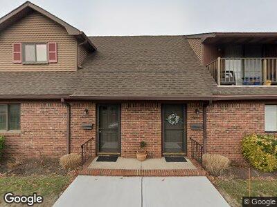
917 Route 88 Unit 2 Point Pleasant Boro, NJ 08742
Estimated Value: $476,000 - $532,000
2
Beds
2
Baths
948
Sq Ft
$519/Sq Ft
Est. Value
About This Home
This home is located at 917 Route 88 Unit 2, Point Pleasant Boro, NJ 08742 and is currently estimated at $492,104, approximately $519 per square foot. 917 Route 88 Unit 2 is a home located in Ocean County with nearby schools including Point Pleasant High School and St. Peter School.
Ownership History
Date
Name
Owned For
Owner Type
Purchase Details
Closed on
Feb 17, 2021
Sold by
Ferro Matthew and Ferro Pamela
Bought by
Koeppen Catherine
Current Estimated Value
Purchase Details
Closed on
Oct 8, 2013
Sold by
Kelbas Kenneth
Bought by
Ferro Matthew and Ferro Pamela
Home Financials for this Owner
Home Financials are based on the most recent Mortgage that was taken out on this home.
Original Mortgage
$157,500
Interest Rate
4.17%
Mortgage Type
New Conventional
Create a Home Valuation Report for This Property
The Home Valuation Report is an in-depth analysis detailing your home's value as well as a comparison with similar homes in the area
Home Values in the Area
Average Home Value in this Area
Purchase History
| Date | Buyer | Sale Price | Title Company |
|---|---|---|---|
| Koeppen Catherine | $351,500 | Truex Abstract Inc | |
| Koeppen Catherine | $351,500 | Old Republic Title | |
| Ferro Matthew | $210,000 | Agent For Fidelity National |
Source: Public Records
Mortgage History
| Date | Status | Borrower | Loan Amount |
|---|---|---|---|
| Previous Owner | Ferro Matthew | $157,500 |
Source: Public Records
Tax History Compared to Growth
Tax History
| Year | Tax Paid | Tax Assessment Tax Assessment Total Assessment is a certain percentage of the fair market value that is determined by local assessors to be the total taxable value of land and additions on the property. | Land | Improvement |
|---|---|---|---|---|
| 2024 | $4,929 | $225,500 | $110,000 | $115,500 |
| 2023 | $4,828 | $225,500 | $110,000 | $115,500 |
| 2022 | $4,828 | $225,500 | $110,000 | $115,500 |
| 2021 | $4,751 | $225,500 | $110,000 | $115,500 |
| 2020 | $4,704 | $225,500 | $110,000 | $115,500 |
| 2019 | $4,641 | $225,500 | $110,000 | $115,500 |
| 2018 | $4,503 | $225,500 | $110,000 | $115,500 |
| 2017 | $4,404 | $225,500 | $110,000 | $115,500 |
| 2016 | $4,370 | $225,500 | $110,000 | $115,500 |
| 2015 | $4,318 | $225,500 | $110,000 | $115,500 |
| 2014 | $4,219 | $225,500 | $110,000 | $115,500 |
Source: Public Records
Map
Nearby Homes
- 1030 Ocean Rd
- 1125 Arnold Ave Unit 2
- 827 Rosewood Ave
- 1215 Johnson Ave
- 916 Arnold Ave
- 1409 Buckner St
- 820 Trenton Ave
- 1320 Charles St
- 1416 George St
- 284 Osborne Ave
- 815 Sinclair Rd
- 22 Cedar Dr
- 842 Arnold Ave Unit 2
- 842 Arnold Ave Unit 1
- 842 Arnold Ave Unit 5
- 842 Arnold Ave Unit 3
- 1115 Sampson Rd
- 1320 Bay Ave
- 1117 Bradford Dr
- 622 Trenton Ave Unit 311
- 917 Route 88 Unit 9
- 917 Route 88 Unit 5
- 917 Route 88 Unit 11
- 917 Route 88 Unit 4
- 917 Route 88 Unit 6
- 917 Route 88 Unit 7
- 917 Route 88 Unit 12
- 917 Route 88 Unit 10
- 917 Route 88 Unit 8
- 917 Route 88 Unit 3
- 917 Route 88 Unit 2
- 917 Route 88 Unit 1
- 917 Ocean Rd Unit 8
- 917 Ocean Rd
- 917 Ocean Rd Unit 11
- 917 Ocean Rd Unit 2
- 917 Ocean Rd Unit 7
- 917 Ocean Rd Unit 4
- 917 Ocean Rd Unit 10
- 909 New Jersey 88 Unit 6