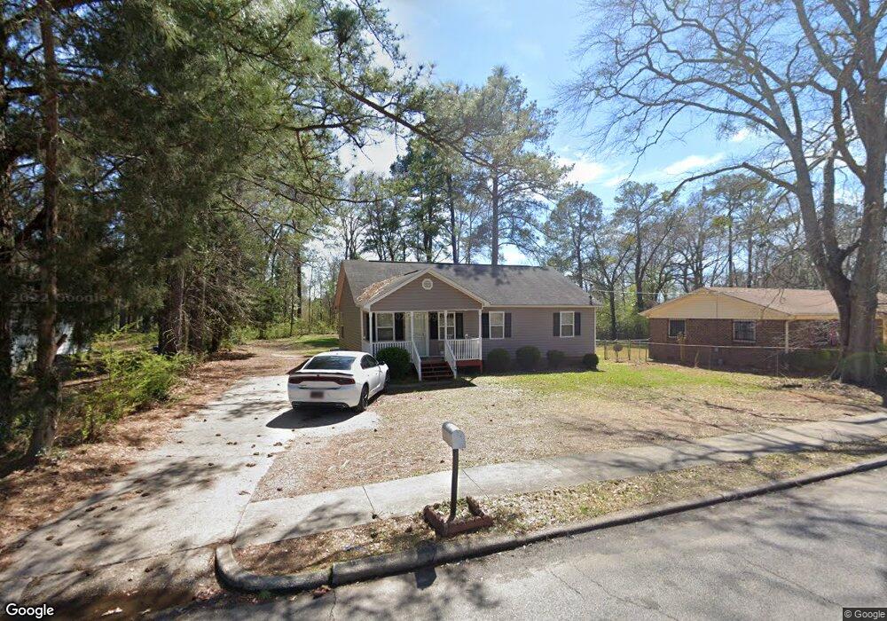
918 Borton St Lagrange, GA 30241
Estimated Value: $88,000 - $155,000
3
Beds
2
Baths
1,271
Sq Ft
$105/Sq Ft
Est. Value
About This Home
This home is located at 918 Borton St, Lagrange, GA 30241 and is currently estimated at $133,870, approximately $105 per square foot. 918 Borton St is a home located in Troup County with nearby schools including Hollis Hand Elementary School, Franklin Forest Elementary School, and Ethel W. Kight Elementary School.
Ownership History
Date
Name
Owned For
Owner Type
Purchase Details
Closed on
Feb 9, 1995
Sold by
Commercial Bank & Trust Co
Bought by
Melvin Smith
Current Estimated Value
Purchase Details
Closed on
Feb 1, 1995
Sold by
Angela Hurston By Atty
Bought by
Commercial Bank & Trust Co
Purchase Details
Closed on
Sep 9, 1991
Sold by
Melvin Smith
Bought by
Angela Hurston By Atty
Purchase Details
Closed on
Jan 1, 1974
Sold by
Laura Hardy and Donnie Atkinson
Bought by
Melvin Smith
Purchase Details
Closed on
Jan 1, 1972
Sold by
Donnie Cox Atkinson
Bought by
Laura Hardy and Donnie Atkinson
Create a Home Valuation Report for This Property
The Home Valuation Report is an in-depth analysis detailing your home's value as well as a comparison with similar homes in the area
Purchase History
| Date | Buyer | Sale Price | Title Company |
|---|---|---|---|
| Melvin Smith | $6,600 | -- | |
| Commercial Bank & Trust Co | $6,600 | -- | |
| Angela Hurston By Atty | $7,000 | -- | |
| Melvin Smith | $2,500 | -- | |
| Laura Hardy | -- | -- |
Source: Public Records
Tax History
| Year | Tax Paid | Tax Assessment Tax Assessment Total Assessment is a certain percentage of the fair market value that is determined by local assessors to be the total taxable value of land and additions on the property. | Land | Improvement |
|---|---|---|---|---|
| 2025 | $1,354 | $49,640 | $3,720 | $45,920 |
| 2024 | $1,226 | $44,960 | $3,720 | $41,240 |
| 2023 | $935 | $34,280 | $3,720 | $30,560 |
| 2022 | $910 | $32,600 | $3,720 | $28,880 |
| 2021 | $900 | $29,840 | $2,520 | $27,320 |
| 2020 | $900 | $29,840 | $2,520 | $27,320 |
| 2019 | $830 | $27,512 | $2,552 | $24,960 |
| 2018 | $830 | $27,512 | $2,552 | $24,960 |
| 2017 | $830 | $27,512 | $2,552 | $24,960 |
| 2016 | $808 | $26,775 | $2,552 | $24,223 |
| 2015 | $809 | $26,775 | $2,552 | $24,223 |
| 2014 | $772 | $25,500 | $2,552 | $22,948 |
| 2013 | -- | $27,391 | $2,552 | $24,839 |
Source: Public Records
Map
Nearby Homes
- 1017 Mason St
- 957 Kelley St
- 0 Kelley St Unit 10550311
- 626 Smoot St
- 510 Smoot St
- 459 Merrywood Dr
- 0 Brown St Unit 10550761
- 0 Brown St Unit 10550754
- 203 Revis St
- 205 Revis St
- 0 Burr St
- 306 Burr St
- 117 Belk St
- LOT 58 Belk St
- 119 Belk St
- LOT 65 Belk St
- LOT 66 Belk St
- 200 Mccall St
- 0 Locust St
- 105 Dix St
Your Personal Tour Guide
Ask me questions while you tour the home.