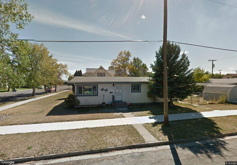
918 E 5th St Laurel, MT 59044
Estimated Value: $266,000 - $279,000
3
Beds
1
Bath
1,232
Sq Ft
$223/Sq Ft
Est. Value
About This Home
This home is located at 918 E 5th St, Laurel, MT 59044 and is currently estimated at $274,518, approximately $222 per square foot. 918 E 5th St is a home located in Yellowstone County with nearby schools including Fred W. Graff School, West School, and Laurel Middle School.
Ownership History
Date
Name
Owned For
Owner Type
Purchase Details
Closed on
Nov 6, 2009
Sold by
Hagemeister Carl and Hagemeister Diane
Bought by
Ewalt Bobbi J
Current Estimated Value
Home Financials for this Owner
Home Financials are based on the most recent Mortgage that was taken out on this home.
Original Mortgage
$150,450
Outstanding Balance
$98,338
Interest Rate
5.02%
Mortgage Type
New Conventional
Estimated Equity
$176,180
Create a Home Valuation Report for This Property
The Home Valuation Report is an in-depth analysis detailing your home's value as well as a comparison with similar homes in the area
Home Values in the Area
Average Home Value in this Area
Purchase History
| Date | Buyer | Sale Price | Title Company |
|---|---|---|---|
| Ewalt Bobbi J | -- | St |
Source: Public Records
Mortgage History
| Date | Status | Borrower | Loan Amount |
|---|---|---|---|
| Open | Ewalt Bobbi J | $150,450 |
Source: Public Records
Tax History
| Year | Tax Paid | Tax Assessment Tax Assessment Total Assessment is a certain percentage of the fair market value that is determined by local assessors to be the total taxable value of land and additions on the property. | Land | Improvement |
|---|---|---|---|---|
| 2025 | $2,895 | $267,200 | $56,449 | $210,751 |
| 2024 | $2,895 | $221,100 | $36,672 | $184,428 |
| 2023 | $2,726 | $221,100 | $36,672 | $184,428 |
| 2022 | $2,460 | $180,900 | $0 | $0 |
| 2021 | $2,475 | $180,900 | $0 | $0 |
| 2020 | $2,375 | $169,200 | $0 | $0 |
| 2019 | $2,383 | $169,200 | $0 | $0 |
| 2018 | $2,313 | $153,600 | $0 | $0 |
| 2017 | $1,308 | $153,600 | $0 | $0 |
| 2016 | $2,147 | $149,600 | $0 | $0 |
| 2015 | $2,130 | $149,600 | $0 | $0 |
| 2014 | $1,894 | $64,076 | $0 | $0 |
Source: Public Records
Map
Nearby Homes
- 801 E 4th St
- 717 E 5th, 506 Alder Ave
- 717 E 5th St
- 605 Date Ave
- 1104 E 8th St
- 1108 E 8th St
- 414 Wyoming Ave
- 516 Pennsylvania Ave
- 1321 E Railroad St
- 809 Pennsylvania Ave
- 1031 Fir Ave
- 110 E 5th St
- 310 1st Ave
- 116 4th Ave
- 603 5th Ave
- 409 Maple Ave
- 319 6th Ave
- 211 Woodland Ave
- 120 Forrest Ave
- 310 (and 814 w 4) 8th Ave
- 416 Cottonwood Ave
- 423 Birch Ave
- 504 Cottonwood Ave
- 419 Birch Ave
- 413 Birch Ave
- 921 E 4th St
- 501 Birch Ave
- 421 Cottonwood Ave
- 911 E 4th St
- 417 Cottonwood Ave
- 508 Cottonwood Ave
- 415 Cottonwood Ave
- 505 Birch Ave
- 409 Birch Ave
- 501 Cottonwood Ave
- 411 Cottonwood Ave
- 411 Cottonwood Ave
- 411 Cottonwood Ave
- 509 Birch Ave
- 514 Cottonwood Ave
Your Personal Tour Guide
Ask me questions while you tour the home.