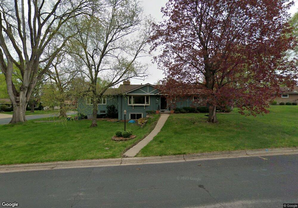
9188 Vincent Cir S Minneapolis, MN 55431
West Bloomington NeighborhoodEstimated Value: $416,000 - $443,000
3
Beds
2
Baths
1,554
Sq Ft
$275/Sq Ft
Est. Value
About This Home
This home is located at 9188 Vincent Cir S, Minneapolis, MN 55431 and is currently estimated at $427,422, approximately $275 per square foot. 9188 Vincent Cir S is a home located in Hennepin County with nearby schools including Washburn Elementary School, Oak Grove Middle School, and Kennedy Senior High School.
Ownership History
Date
Name
Owned For
Owner Type
Purchase Details
Closed on
Oct 30, 2015
Sold by
Perske Audrey M
Bought by
Rolli Samuel J and Rolli Nastassia M
Current Estimated Value
Home Financials for this Owner
Home Financials are based on the most recent Mortgage that was taken out on this home.
Original Mortgage
$208,000
Outstanding Balance
$164,045
Interest Rate
3.87%
Mortgage Type
New Conventional
Estimated Equity
$263,377
Create a Home Valuation Report for This Property
The Home Valuation Report is an in-depth analysis detailing your home's value as well as a comparison with similar homes in the area
Home Values in the Area
Average Home Value in this Area
Purchase History
| Date | Buyer | Sale Price | Title Company |
|---|---|---|---|
| Rolli Samuel J | $260,000 | Global Closing & Title Svcs |
Source: Public Records
Mortgage History
| Date | Status | Borrower | Loan Amount |
|---|---|---|---|
| Open | Rolli Samuel J | $208,000 |
Source: Public Records
Tax History Compared to Growth
Tax History
| Year | Tax Paid | Tax Assessment Tax Assessment Total Assessment is a certain percentage of the fair market value that is determined by local assessors to be the total taxable value of land and additions on the property. | Land | Improvement |
|---|---|---|---|---|
| 2024 | $5,226 | $410,100 | $153,700 | $256,400 |
| 2023 | $4,774 | $397,100 | $144,600 | $252,500 |
| 2022 | $4,162 | $389,000 | $141,600 | $247,400 |
| 2021 | $3,826 | $330,400 | $139,300 | $191,100 |
| 2020 | $3,948 | $308,700 | $135,400 | $173,300 |
| 2019 | $3,340 | $309,400 | $135,400 | $174,000 |
| 2018 | $3,332 | $261,700 | $133,400 | $128,300 |
| 2017 | $3,059 | $238,000 | $119,700 | $118,300 |
| 2016 | $3,168 | $234,100 | $114,900 | $119,200 |
| 2015 | $3,161 | $225,500 | $111,500 | $114,000 |
| 2014 | -- | $208,900 | $108,000 | $100,900 |
Source: Public Records
Map
Nearby Homes
- 9116 Vincent Ave S
- 9516 Russell Ave S
- 2300 W 95th St
- 9632 Vincent Ave S
- 9132 Morgan Ave S
- 9016 Morgan Ave S
- 9540 Penn Cir
- 9101 Morgan Ave S
- 8541 Queen Ave S
- 8545 Penn Ave S
- 8516 Zenith Cir S
- 8525 Penn Ave S
- 2311 Jones Place W
- 9917 Brookside Cir
- 3801 W 98th St Unit 402
- 3801 W 98th St Unit 109
- 9018 Kell Cir
- 3608 W 99th St
- 8549 Irwin Rd Unit 239
- 10004 Maple Cir
- 9196 Vincent Ave S
- 9186 Vincent Cir S
- 9172 Vincent Ave S
- 9178 Vincent Cir S
- 9181 Vincent Ave S
- 9189 Vincent Ave S
- 9198 Vincent Ave S
- 9173 Vincent Ave S
- 9184 Vincent Cir S
- 9197 Vincent Ave S
- 9182 Vincent Cir S
- 2908 W 92nd St
- 9180 Vincent Cir S
- 9165 Vincent Ave S
- 9201 Vincent Ave S
- 9164 Vincent Ave S
- 2916 W 92nd St
- 9157 Vincent Ave S
- 9140 Upton Ave S
- 9209 Vincent Ave S