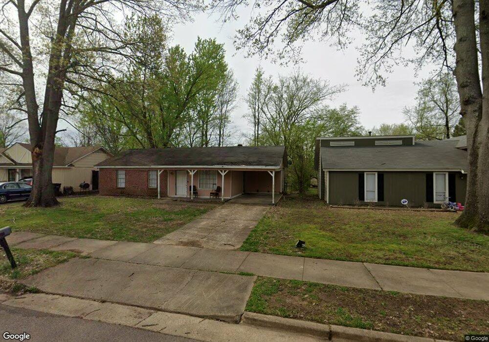
919 Chesterton Dr Memphis, TN 38127
Estimated Value: $88,777 - $108,000
3
Beds
2
Baths
1,125
Sq Ft
$88/Sq Ft
Est. Value
About This Home
This home is located at 919 Chesterton Dr, Memphis, TN 38127 and is currently estimated at $98,944, approximately $87 per square foot. 919 Chesterton Dr is a home located in Shelby County with nearby schools including Northaven Elementary School, Woodstock Middle School, and Trezevant High School.
Ownership History
Date
Name
Owned For
Owner Type
Purchase Details
Closed on
Apr 9, 2025
Sold by
919 Chesterton Land Trust and Memphis Escrow Company Inc
Bought by
Cao Carly T
Current Estimated Value
Purchase Details
Closed on
Jan 2, 2003
Sold by
R & M Memphis Lp
Bought by
919 Chesterton Land Trust and Memphis Escrow Co Inc
Purchase Details
Closed on
Dec 1, 1997
Sold by
Knapp Richard L P
Bought by
R & M Memphis Lp
Purchase Details
Closed on
Jul 10, 1996
Sold by
Knapp Richard A
Bought by
Richard Knapp Lp
Purchase Details
Closed on
Apr 5, 1995
Bought by
Knapp Richard A
Create a Home Valuation Report for This Property
The Home Valuation Report is an in-depth analysis detailing your home's value as well as a comparison with similar homes in the area
Home Values in the Area
Average Home Value in this Area
Purchase History
| Date | Buyer | Sale Price | Title Company |
|---|---|---|---|
| Cao Carly T | -- | None Listed On Document | |
| 919 Chesterton Land Trust | -- | -- | |
| R & M Memphis Lp | -- | -- | |
| Richard Knapp Lp | -- | -- | |
| Knapp Richard A | $28,100 | -- |
Source: Public Records
Tax History Compared to Growth
Tax History
| Year | Tax Paid | Tax Assessment Tax Assessment Total Assessment is a certain percentage of the fair market value that is determined by local assessors to be the total taxable value of land and additions on the property. | Land | Improvement |
|---|---|---|---|---|
| 2025 | $412 | $20,450 | $2,000 | $18,450 |
| 2024 | $412 | $12,150 | $1,475 | $10,675 |
| 2023 | $412 | $12,150 | $1,475 | $10,675 |
| 2022 | $412 | $12,150 | $1,475 | $10,675 |
| 2021 | $419 | $12,150 | $1,475 | $10,675 |
| 2020 | $333 | $8,225 | $1,475 | $6,750 |
| 2019 | $333 | $8,225 | $1,475 | $6,750 |
| 2018 | $333 | $8,225 | $1,475 | $6,750 |
| 2017 | $338 | $8,225 | $1,475 | $6,750 |
| 2016 | $403 | $9,225 | $0 | $0 |
| 2014 | $403 | $9,225 | $0 | $0 |
Source: Public Records
Map
Nearby Homes
- 936 Chesterton Dr
- 901 Chesterton Dr
- 5046 Breckenwood Dr
- 5030 Breckenwood Dr
- 980 N Circle Rd
- 5088 Breckenwood Dr
- 5090 Belfast Dr
- 5096 Belfast Dr
- 850 Carol Ann Cove
- 881 Northaven Dr
- 810 Northaven Dr
- 5072 Blacksmith Dr
- 5140 Blacksmith Dr
- 706 Northaven Dr
- 759 Brandywine Blvd
- 823 Bitter Creek Cove
- 5338 Cedar Bluff Dr
- 4710 E Circle Rd
- 5371 Cedar Bluff Dr
- 5315 Braden Dr
- 925 Chesterton Dr
- 911 Chesterton Dr
- 931 Chesterton Dr
- 907 Chesterton Dr
- 937 Chesterton Dr
- 922 Chesterton Dr
- 928 Chesterton Dr
- 5043 Chesterton Cove
- 943 Chesterton Dr
- 895 Chesterton Dr
- 900 Chesterton Dr
- 5050 Chesterton Cove
- 949 Chesterton Dr
- 889 Chesterton Dr
- 5053 Chesterton Cove
- 5049 Coke Cove
- 5048 Carterville Place
- 955 Chesterton Dr
- 952 Chesterton Dr
- 5056 Carterville Place