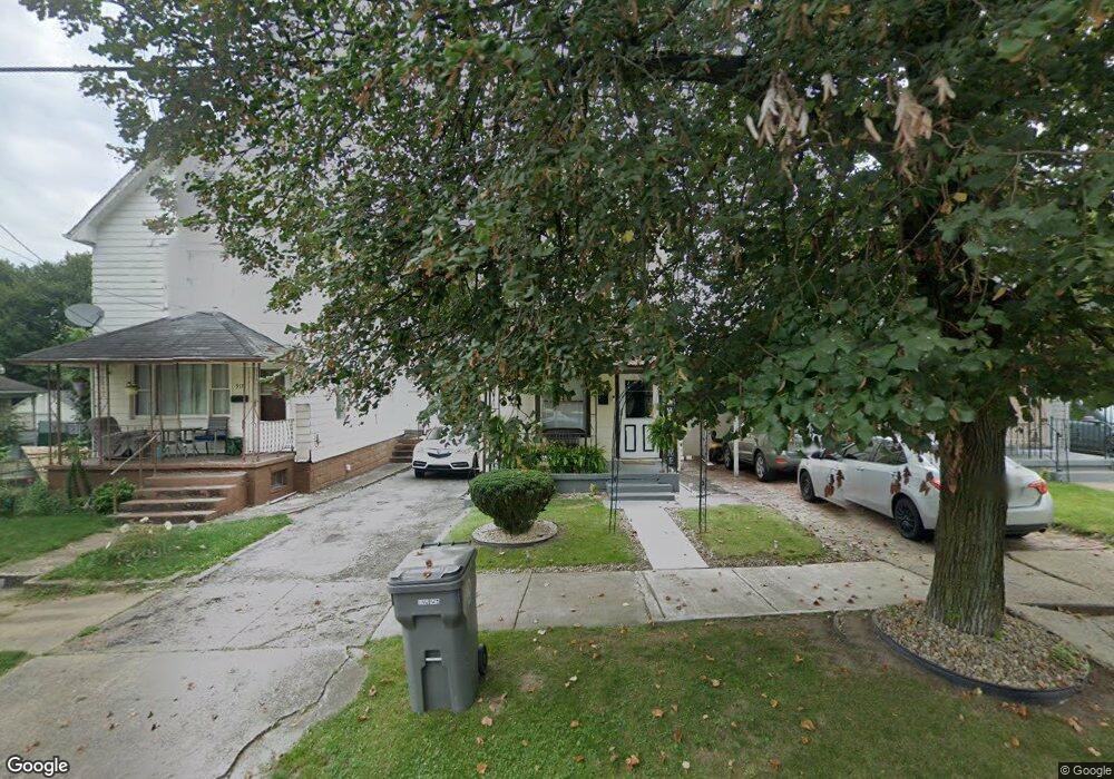
919 Franklin Ave Youngstown, OH 44502
Lower Gibson NeighborhoodEstimated Value: $40,000 - $61,000
2
Beds
1
Bath
1,024
Sq Ft
$47/Sq Ft
Est. Value
About This Home
This home is located at 919 Franklin Ave, Youngstown, OH 44502 and is currently estimated at $48,443, approximately $47 per square foot. 919 Franklin Ave is a home located in Mahoning County with nearby schools including Taft Elementary School, East High School, and South Side Academy.
Ownership History
Date
Name
Owned For
Owner Type
Purchase Details
Closed on
Nov 28, 2017
Sold by
Gonzalez Teresita Nieves
Bought by
Diaz Neves Luis Angel
Current Estimated Value
Purchase Details
Closed on
Aug 2, 2016
Sold by
Bonilla Edna and Bonilla Hilda
Bought by
Gonzalez Teresita Nieves
Purchase Details
Closed on
Aug 3, 2001
Sold by
Mike Smaldino and Brian Rella
Bought by
Hernandez Fortunato
Purchase Details
Closed on
May 20, 1975
Bought by
Gonzales Rafael S and Gonzales M
Create a Home Valuation Report for This Property
The Home Valuation Report is an in-depth analysis detailing your home's value as well as a comparison with similar homes in the area
Home Values in the Area
Average Home Value in this Area
Purchase History
| Date | Buyer | Sale Price | Title Company |
|---|---|---|---|
| Diaz Neves Luis Angel | -- | None Available | |
| Gonzalez Teresita Nieves | $7,000 | Attorney | |
| Hernandez Fortunato | $4,000 | -- | |
| Gonzales Rafael S | -- | -- |
Source: Public Records
Tax History Compared to Growth
Tax History
| Year | Tax Paid | Tax Assessment Tax Assessment Total Assessment is a certain percentage of the fair market value that is determined by local assessors to be the total taxable value of land and additions on the property. | Land | Improvement |
|---|---|---|---|---|
| 2024 | $182 | $3,670 | $290 | $3,380 |
| 2023 | $181 | $3,670 | $290 | $3,380 |
| 2022 | $125 | $1,940 | $290 | $1,650 |
| 2021 | $125 | $1,940 | $290 | $1,650 |
| 2020 | $123 | $1,940 | $290 | $1,650 |
| 2019 | $139 | $1,940 | $290 | $1,650 |
| 2018 | $147 | $1,940 | $290 | $1,650 |
| 2017 | $139 | $1,940 | $290 | $1,650 |
| 2016 | $142 | $2,100 | $290 | $1,810 |
| 2015 | $139 | $2,100 | $290 | $1,810 |
| 2014 | $138 | $2,100 | $290 | $1,810 |
| 2013 | $136 | $2,100 | $290 | $1,810 |
Source: Public Records
Map
Nearby Homes
- 702 Dickson St
- 708 Dickson St
- 632 Samuel Ave
- 427 Knox St
- 537 Samuel Ave
- 525 Samuel Ave
- 0 South Ave Unit 5125788
- 444 Emery Ave
- 968 Cameron Ave
- 718 E Laclede Ave
- 724 E Laclede Ave
- 884 E Dewey Ave
- 0000 S Ave
- 834 Compton Ln
- 919 E Dewey Ave
- 240 E Laclede Ave
- 941 E Dewey Ave
- 152 Regent St
- 153 W Warren Ave
- 196 W Delason Ave
- 917 Franklin Ave
- 921 Franklin Ave
- 913 Franklin Ave
- 911 Franklin Ave
- 616 Gibson St
- 909 Franklin Ave
- 612 Gibson St
- 926 Franklin Ave
- 922 Franklin Ave
- 916 Franklin Ave
- 1009 Franklin Ave
- 932 Franklin Ave
- 1011 Franklin Ave
- 630 Gibson St
- 1002 Franklin Ave
- 1004 Franklin Ave
- 636 Gibson St
- 1015 Franklin Ave
- 1008 Franklin Ave
- 1019 Franklin Ave