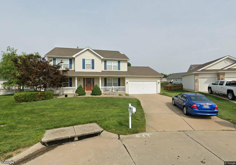
919 Hampshire Heath Dr O Fallon, MO 63368
Estimated Value: $443,000 - $497,000
3
Beds
3
Baths
2,634
Sq Ft
$180/Sq Ft
Est. Value
About This Home
This home is located at 919 Hampshire Heath Dr, O Fallon, MO 63368 and is currently estimated at $474,439, approximately $180 per square foot. 919 Hampshire Heath Dr is a home located in St. Charles County with nearby schools including G.L. Priess Primary School, Quest Elementary School, and Prairie View Elementary School.
Ownership History
Date
Name
Owned For
Owner Type
Purchase Details
Closed on
Sep 13, 2001
Sold by
Casper Homes & Development Company
Bought by
Fredrick Brett A and Fredrick Jennifer G
Current Estimated Value
Home Financials for this Owner
Home Financials are based on the most recent Mortgage that was taken out on this home.
Original Mortgage
$166,500
Outstanding Balance
$64,057
Interest Rate
6.96%
Mortgage Type
FHA
Estimated Equity
$410,382
Create a Home Valuation Report for This Property
The Home Valuation Report is an in-depth analysis detailing your home's value as well as a comparison with similar homes in the area
Home Values in the Area
Average Home Value in this Area
Purchase History
| Date | Buyer | Sale Price | Title Company |
|---|---|---|---|
| Fredrick Brett A | $185,901 | -- |
Source: Public Records
Mortgage History
| Date | Status | Borrower | Loan Amount |
|---|---|---|---|
| Open | Fredrick Brett A | $166,500 |
Source: Public Records
Tax History Compared to Growth
Tax History
| Year | Tax Paid | Tax Assessment Tax Assessment Total Assessment is a certain percentage of the fair market value that is determined by local assessors to be the total taxable value of land and additions on the property. | Land | Improvement |
|---|---|---|---|---|
| 2025 | $4,523 | $77,997 | -- | -- |
| 2024 | $4,523 | $70,410 | -- | -- |
| 2023 | $4,523 | $70,410 | $0 | $0 |
| 2022 | $4,025 | $58,416 | $0 | $0 |
| 2021 | $4,029 | $58,416 | $0 | $0 |
| 2020 | $3,799 | $52,825 | $0 | $0 |
| 2019 | $3,530 | $52,825 | $0 | $0 |
| 2018 | $3,817 | $54,449 | $0 | $0 |
| 2017 | $3,816 | $54,449 | $0 | $0 |
| 2016 | $3,350 | $45,787 | $0 | $0 |
| 2015 | $3,306 | $45,787 | $0 | $0 |
| 2014 | $2,513 | $37,273 | $0 | $0 |
Source: Public Records
Map
Nearby Homes
- 842 Brockwell Dr
- The Carlton II Plan at Inverness
- The Stansbury II Plan at Inverness
- The Berkshire II Plan at Inverness
- The Bellwynn Plan at Inverness
- The Carlton Plan at Inverness
- The Berkshire Plan at Inverness
- The Glenwyck II Plan at Inverness
- The Stansbury Plan at Inverness
- The Vanguard II Plan at Inverness
- The Rochester Plan at Inverness
- The Bellwynn II Plan at Inverness
- The Glenwyck Plan at Inverness
- The Vanguard Plan at Inverness
- The Rochester II Plan at Inverness
- 243 Greenshire Ln
- 11 Warchol Ct
- 662 Knollshire Way
- 321 Kingsbarns Ct
- 325 Kingsbarns Ct
- 921 Hampshire Heath Dr
- 917 Hampshire Heath Dr
- 939 Hampshire Heath Dr
- 945 Hampshire Heath Dr
- 935 Hampshire Heath Dr
- 927 Hampshire Heath Dr
- 947 Hampshire Heath Dr
- 915 Hampshire Heath Dr
- 949 Hampshire Heath Dr
- 920 Hampshire Heath Dr
- 918 Hampshire Heath Dr
- 911 Hampshire Heath Dr
- 922 Hampshire Heath Dr
- 916 Hampshire Heath Dr
- 951 Hampshire Heath Dr
- 944 Hampshire Heath Dr
- 932 Hampshire Heath Dr
- 942 Hampshire Heath Dr
- 934 Hampshire Heath Dr
- 930 Hampshire Heath Dr