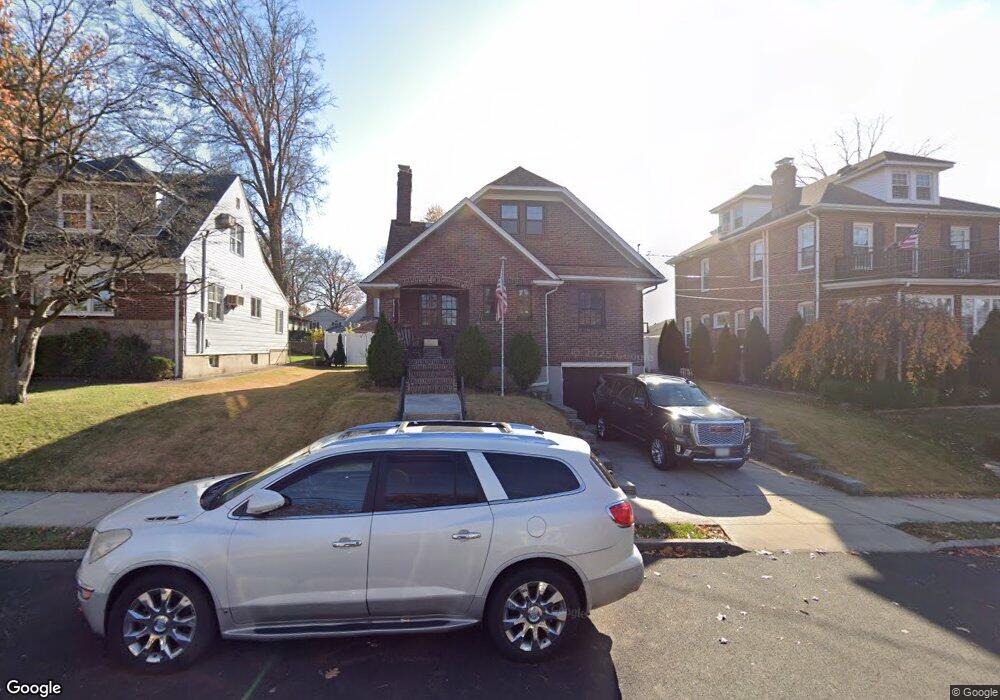
92 Crowell Ave Staten Island, NY 10314
Westerleigh NeighborhoodEstimated Value: $781,938 - $904,000
--
Bed
4
Baths
1,358
Sq Ft
$613/Sq Ft
Est. Value
About This Home
This home is located at 92 Crowell Ave, Staten Island, NY 10314 and is currently estimated at $832,485, approximately $613 per square foot. 92 Crowell Ave is a home located in Richmond County with nearby schools including P.S. 30 Westerleigh, I.S. 51 Edwin Markham, and Susan E Wagner High School.
Ownership History
Date
Name
Owned For
Owner Type
Purchase Details
Closed on
May 13, 2008
Sold by
Canovas Joseph M and Canovas Phyllis
Bought by
Canovas Joseph M and Canovas Phyllis
Current Estimated Value
Purchase Details
Closed on
Dec 19, 1996
Sold by
Sinclair Betty A and Schriek Betty A
Bought by
Canovas Joseph M and Canovas Phyllis
Purchase Details
Closed on
Jul 5, 1994
Sold by
Schriek Betty A and Keck Nancy D
Bought by
Schriek Betty A
Create a Home Valuation Report for This Property
The Home Valuation Report is an in-depth analysis detailing your home's value as well as a comparison with similar homes in the area
Home Values in the Area
Average Home Value in this Area
Purchase History
| Date | Buyer | Sale Price | Title Company |
|---|---|---|---|
| Canovas Joseph M | -- | None Available | |
| Canovas Joseph M | $215,000 | -- | |
| Schriek Betty A | -- | Chicago Title Insurance Co |
Source: Public Records
Tax History Compared to Growth
Tax History
| Year | Tax Paid | Tax Assessment Tax Assessment Total Assessment is a certain percentage of the fair market value that is determined by local assessors to be the total taxable value of land and additions on the property. | Land | Improvement |
|---|---|---|---|---|
| 2025 | $7,452 | $48,540 | $15,585 | $32,955 |
| 2024 | $7,733 | $41,580 | $18,056 | $23,524 |
| 2023 | $7,092 | $36,323 | $15,411 | $20,912 |
| 2022 | $6,554 | $38,820 | $19,500 | $19,320 |
| 2021 | $6,500 | $34,140 | $19,500 | $14,640 |
| 2020 | $6,547 | $36,960 | $19,500 | $17,460 |
| 2019 | $6,419 | $40,080 | $19,500 | $20,580 |
| 2018 | $5,873 | $30,269 | $14,883 | $15,386 |
| 2017 | $5,521 | $28,556 | $16,998 | $11,558 |
| 2016 | $5,076 | $26,940 | $19,500 | $7,440 |
| 2015 | $4,854 | $28,492 | $16,605 | $11,887 |
| 2014 | $4,854 | $26,880 | $16,680 | $10,200 |
Source: Public Records
Map
Nearby Homes
- 160 Westcott Blvd
- 36 Sawyer Ave
- 125 Westcott Blvd
- 80 Kemball Ave
- 25 Coale Ave
- 142 Margaretta Ct
- 148 Sturges St
- 136 Sturges St
- 14 Leonard Ave
- 751 Jewett Ave Unit 17
- 751 Jewett Ave
- 48 Markham Place
- 254 Rice Ave
- 204 Utter Ave
- 328 Manor Rd
- 17 Carolina Place
- 21 Winthrop Place
- 307 Fiske Ave
- 25 Winthrop Place
- 307 Clinton B Fiske Ave
- 96 Crowell Ave
- 82 Crowell Ave
- 100 Crowell Ave
- 111 Kemball Ave
- 107 Kemball Ave
- 115 Kemball Ave
- 80 Crowell Ave
- 103 Kemball Ave
- 121 Kemball Ave
- 0 Crowell Ave
- 76 Crowell Ave
- 91 Crowell Ave
- 99 Kemball Ave
- 87 Crowell Ave
- 108 Crowell Ave
- 95 Crowell Ave
- 193 Westcott Blvd
- 83 Crowell Ave
- 97 Crowell Ave
- 97 Kemball Ave