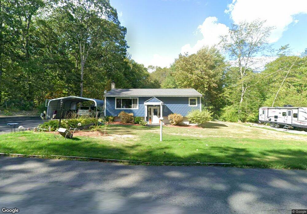
92 Pail Factory Rd Templeton, MA 01468
Estimated Value: $311,000 - $347,000
2
Beds
1
Bath
976
Sq Ft
$343/Sq Ft
Est. Value
About This Home
This home is located at 92 Pail Factory Rd, Templeton, MA 01468 and is currently estimated at $334,939, approximately $343 per square foot. 92 Pail Factory Rd is a home located in Worcester County with nearby schools including Narragansett Regional High School.
Ownership History
Date
Name
Owned For
Owner Type
Purchase Details
Closed on
Dec 30, 2016
Sold by
Sosa Ana E
Bought by
Gould Michael P and Gould Evelyn
Current Estimated Value
Home Financials for this Owner
Home Financials are based on the most recent Mortgage that was taken out on this home.
Original Mortgage
$140,250
Outstanding Balance
$114,980
Interest Rate
3.94%
Mortgage Type
New Conventional
Estimated Equity
$219,959
Purchase Details
Closed on
Oct 28, 2004
Sold by
Caissie Bobby and Caissie Monika
Bought by
Sosa Ana E and Ledoux Richard R
Home Financials for this Owner
Home Financials are based on the most recent Mortgage that was taken out on this home.
Original Mortgage
$94,000
Interest Rate
5.74%
Mortgage Type
Purchase Money Mortgage
Purchase Details
Closed on
Jan 31, 1996
Sold by
Cabral Janet M
Bought by
Caissie Bobby and Legault Monika
Create a Home Valuation Report for This Property
The Home Valuation Report is an in-depth analysis detailing your home's value as well as a comparison with similar homes in the area
Home Values in the Area
Average Home Value in this Area
Purchase History
| Date | Buyer | Sale Price | Title Company |
|---|---|---|---|
| Gould Michael P | $165,000 | -- | |
| Sosa Ana E | $184,900 | -- | |
| Caissie Bobby | $78,000 | -- |
Source: Public Records
Mortgage History
| Date | Status | Borrower | Loan Amount |
|---|---|---|---|
| Open | Gould Michael P | $140,250 | |
| Previous Owner | Caissie Bobby | $125,928 | |
| Previous Owner | Sosa Ana E | $94,000 | |
| Previous Owner | Caissie Bobby | $97,000 | |
| Previous Owner | Caissie Bobby | $26,133 |
Source: Public Records
Tax History Compared to Growth
Tax History
| Year | Tax Paid | Tax Assessment Tax Assessment Total Assessment is a certain percentage of the fair market value that is determined by local assessors to be the total taxable value of land and additions on the property. | Land | Improvement |
|---|---|---|---|---|
| 2025 | $3,282 | $270,800 | $58,900 | $211,900 |
| 2024 | $3,316 | $263,200 | $51,900 | $211,300 |
| 2023 | $3,186 | $246,600 | $51,900 | $194,700 |
| 2022 | $2,990 | $196,200 | $37,100 | $159,100 |
| 2021 | $2,758 | $171,200 | $37,100 | $134,100 |
| 2020 | $2,694 | $160,100 | $37,100 | $123,000 |
| 2018 | $2,433 | $145,500 | $33,600 | $111,900 |
| 2017 | $2,167 | $134,400 | $33,600 | $100,800 |
| 2016 | $2,105 | $127,800 | $33,600 | $94,200 |
| 2015 | $2,155 | $129,500 | $35,300 | $94,200 |
| 2014 | $2,066 | $127,200 | $35,300 | $91,900 |
Source: Public Records
Map
Nearby Homes
- 72 Cottage Ln Unit (B)
- 72 Cottage Ln Unit (A)
- 23 Schoolhouse Rd
- 18 S Main St
- 14 Baker Ln
- 104 Patriots Rd
- 3 Gary Rd
- 0 Gardner Rd Unit Willow
- 0 Gardner Rd Unit Applewood
- 89 Patriots Rd
- 133 Patriots Rd
- 87 Hubbardston Rd
- 171 South Rd
- 283 Mill St
- 747 Timpany Blvd
- 0 Hubbardston Rd Unit 73407169
- 126 Dyer St
- 4 Pitcherville Rd
- 19 Stephanie Dr
- 155 Mill St
- 86 Pail Factory Rd
- 98 Pail Factory Rd
- 80 Pail Factory Rd
- 0 Pail Factory Rd L:f Unit 71484557
- 1 Shady Ln
- 5 Shady Ln
- 13 Shady Ln
- 66 Pail Factory Rd
- 75 Pail Factory Rd
- 19 Shady Ln
- 116 Pail Factory Rd
- 69 Pail Factory Rd
- 25 Shady Ln
- 213 Turner Ln
- 203 Turner Ln
- 125 Pail Factory Rd
- 31 Shady Ln
- 32 Shady Ln
- 52 Pail Factory Rd
- 37 Shady Ln