Estimated Value: $212,000 - $238,000
3
Beds
2
Baths
1,527
Sq Ft
$148/Sq Ft
Est. Value
About This Home
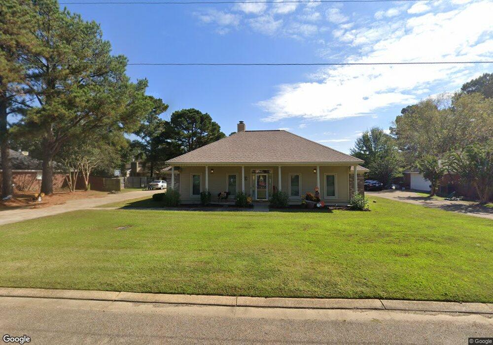
This home is located at 920 Eagles Nest Dr, Byram, MS 39272 and is currently estimated at $225,449, approximately $147 per square foot. 920 Eagles Nest Dr is a home located in Hinds County with nearby schools including Gary Road Elementary School, Gary Road Intermediate School, and Byram Middle School.
Ownership History
Date
Name
Owned For
Owner Type
Purchase Details
Closed on
Oct 26, 2011
Sold by
Wilson William N and Wilson Nancy R
Bought by
Reed Kenyatta M and Reed Jermaine
Current Estimated Value
Home Financials for this Owner
Home Financials are based on the most recent Mortgage that was taken out on this home.
Original Mortgage
$125,729
Outstanding Balance
$92,549
Interest Rate
5.75%
Mortgage Type
FHA
Estimated Equity
$132,900
Create a Home Valuation Report for This Property
The Home Valuation Report is an in-depth analysis detailing your home's value as well as a comparison with similar homes in the area
Home Values in the Area
Average Home Value in this Area
Purchase History
| Date | Buyer | Sale Price | Title Company |
|---|---|---|---|
| Reed Kenyatta M | -- | -- |
Source: Public Records
Mortgage History
| Date | Status | Borrower | Loan Amount |
|---|---|---|---|
| Open | Reed Kenyatta M | $125,729 |
Source: Public Records
Tax History
| Year | Tax Paid | Tax Assessment Tax Assessment Total Assessment is a certain percentage of the fair market value that is determined by local assessors to be the total taxable value of land and additions on the property. | Land | Improvement |
|---|---|---|---|---|
| 2025 | $1,475 | $11,618 | $2,500 | $9,118 |
| 2024 | $1,475 | $11,347 | $2,500 | $8,847 |
| 2023 | $1,475 | $11,347 | $2,500 | $8,847 |
| 2022 | $1,746 | $11,347 | $2,500 | $8,847 |
| 2021 | $1,423 | $11,347 | $2,500 | $8,847 |
| 2020 | $1,377 | $11,193 | $2,500 | $8,693 |
| 2019 | $1,369 | $11,193 | $2,500 | $8,693 |
| 2018 | $1,369 | $11,193 | $2,500 | $8,693 |
| 2017 | $1,338 | $11,193 | $2,500 | $8,693 |
| 2016 | $1,338 | $11,193 | $2,500 | $8,693 |
| 2015 | $1,317 | $11,049 | $2,500 | $8,549 |
| 2014 | $1,294 | $11,049 | $2,500 | $8,549 |
Source: Public Records
Map
Nearby Homes
- 8834 Gary Rd
- 2120 Meagan Dr
- 699 Meadow Ln
- 85 Susan Cove
- 1213 Lake Shore Dr
- 109 Lucas Ct
- 324 Martha Dr
- 0 Terry Rd Unit 24270230
- 0 Terry Rd Unit 4135800
- 0 Terry Rd Unit 4130083
- 224 Brannan Ave
- 344 Brannan Ave
- 213 Longfellow Cove
- 812 Fairway Ave
- 805 Fairway Ave
- 801 Fairway Ave
- 808 Fairway Ave
- 809 Fairway Ave
- 212 Callaway Cir
- 5301 Gardens Way
- 922 Eagles Nest Dr
- 106 Canyon Cove
- 929 Eagles Nest Dr
- 927 Eagles Nest Dr
- 931 Eagles Nest Dr
- 924 Eagles Nest Dr
- 916 Eagles Nest Dr
- 102 Canyon Cove
- 925 Eagles Nest Dr
- 933 Eagles Nest Dr
- 108 Canyon Cove
- 926 Eagles Nest Dr
- 923 Eagles Nest Dr
- 914 Eagles Nest Dr
- 103 Canyon Cove
- 935 Eagles Nest Dr
- 514 Golden Eagle Dr
- 512 Golden Eagle Dr
- 107 Canyon Cove
- 105 Canyon Cove
Your Personal Tour Guide
Ask me questions while you tour the home.