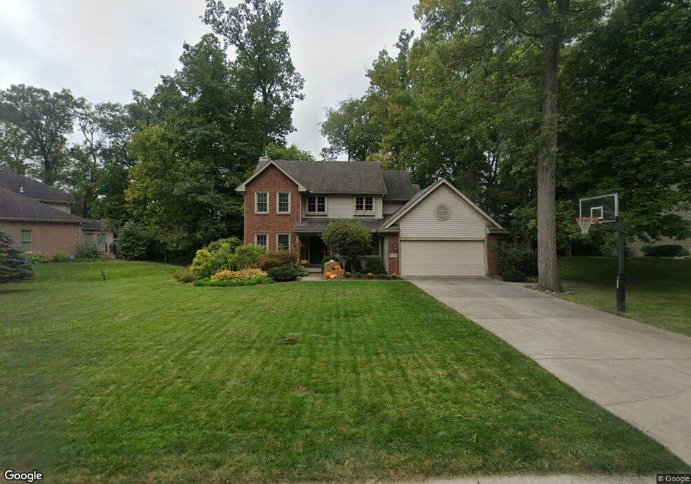
923 Forest Edge Ave Springfield, OH 45503
Estimated Value: $382,095 - $482,000
4
Beds
3
Baths
2,202
Sq Ft
$196/Sq Ft
Est. Value
About This Home
This home is located at 923 Forest Edge Ave, Springfield, OH 45503 and is currently estimated at $431,524, approximately $195 per square foot. 923 Forest Edge Ave is a home located in Clark County with nearby schools including Northridge Elementary School, Kenton Ridge Middle & High School, and Emmanuel Christian Academy.
Ownership History
Date
Name
Owned For
Owner Type
Purchase Details
Closed on
Mar 10, 2022
Sold by
Mayhan Mark J and Mayhan Donna H
Bought by
Mayhan Family Trust
Current Estimated Value
Purchase Details
Closed on
May 23, 2000
Sold by
Hbh Builders Ltd
Bought by
Mayhan Mark J and Hieber Donna G
Home Financials for this Owner
Home Financials are based on the most recent Mortgage that was taken out on this home.
Original Mortgage
$189,600
Interest Rate
8.18%
Mortgage Type
Purchase Money Mortgage
Create a Home Valuation Report for This Property
The Home Valuation Report is an in-depth analysis detailing your home's value as well as a comparison with similar homes in the area
Home Values in the Area
Average Home Value in this Area
Purchase History
| Date | Buyer | Sale Price | Title Company |
|---|---|---|---|
| Mayhan Family Trust | -- | Simpson Nathaniel T | |
| Mayhan Mark J | $237,000 | First Title Agency Inc |
Source: Public Records
Mortgage History
| Date | Status | Borrower | Loan Amount |
|---|---|---|---|
| Previous Owner | Mayhan Mark J | $189,600 |
Source: Public Records
Tax History
| Year | Tax Paid | Tax Assessment Tax Assessment Total Assessment is a certain percentage of the fair market value that is determined by local assessors to be the total taxable value of land and additions on the property. | Land | Improvement |
|---|---|---|---|---|
| 2025 | $4,271 | $126,170 | $22,190 | $103,980 |
| 2024 | $4,131 | $97,680 | $17,380 | $80,300 |
| 2023 | $4,131 | $97,680 | $17,380 | $80,300 |
| 2022 | $4,146 | $97,680 | $17,380 | $80,300 |
| 2021 | $4,291 | $85,680 | $15,240 | $70,440 |
| 2020 | $4,294 | $85,680 | $15,240 | $70,440 |
| 2019 | $4,376 | $85,680 | $15,240 | $70,440 |
| 2018 | $3,868 | $72,680 | $16,010 | $56,670 |
| 2017 | $3,315 | $72,675 | $16,006 | $56,669 |
| 2016 | $3,292 | $72,675 | $16,006 | $56,669 |
| 2015 | $3,251 | $69,133 | $15,243 | $53,890 |
| 2014 | $3,250 | $69,133 | $15,243 | $53,890 |
| 2013 | $3,175 | $69,133 | $15,243 | $53,890 |
Source: Public Records
Map
Nearby Homes
- 862 Brendle Trace Unit 20
- 4343 Burchill St
- 593 Hiser Ave
- 4741 Cullen Ave
- 4802 Willowbrook Dr
- 1341 Student Ave
- 4256 Midfield St Unit 9
- 4446 Ridgewood Rd E Unit 3
- 4577 Reno Ln Unit 2
- 1162 Kingsgate Rd
- 1201 Kingsgate Rd
- 4652 Reno Ln Unit 15
- 5033 Ridgewood Rd E
- 1709 Thomas Dr
- 1521 Erika Dr
- 0 Moorefield Rd
- 1500 Kingsgate Rd
- 1502 Kingsgate Rd
- 1500 Kingsgate Rd Unit 19430
- 1502 Kingsgate Rd Unit 19432
- 927 Forest Edge Ave
- 917 Forest Edge Ave
- 899 Forest Edge Ave
- 4505 Dunnwood Ln
- 920 Forest Edge Ave
- 918 Forest Edge Ave
- 954 Forest Edge Ave
- 891 Forest Edge Ave
- 4504 Dunnwood Ln
- 896 Forest Edge Ave
- 925 Sawmill Ct
- 4514 Dunnwood Ln
- 921 Sawmill Ct
- 909 Sawmill Ct
- 4501 Derr Rd
- 4522 Dunnwood Ln
- 4509 Derr Rd
- 4495 Windwood St
- 4499 Windwood St
- 4503 Windwood St
Your Personal Tour Guide
Ask me questions while you tour the home.